In weekend weather, monitoring severe weather risks for the South
Feb 14, 2026
In my Wednesday newsletter, I discussed the Trump Administration’s plans to announce on Thursday the revocation of the Environmental Protection Agency’s endangerment finding that greenhouse gases (GHG) pose a threat to human health through climate change impacts. The administration followed through with their plans as outlined in this press release from the EPA.
As I alluded to in my Wednesday post, I do not feel qualified to provide insight on the economic and environmental benefits and costs of specific regulations that have been implemented in the years since the endangerment finding was implemented in 2009. However, as an atmospheric scientist I do strongly feel that the scientific evidence in the last 15 years has been in the direction of climate change being a potentially even greater risk to society than we might have realized, and there is little doubt that GHGs are the primary cause.
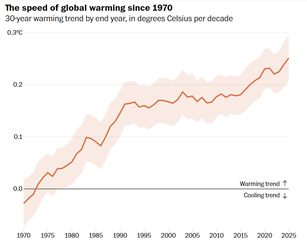
Ironically, as the administration was announcing the end of the endangerment finding, the Washington Post published a detailed analysis of global temperature data that support the likelihood that global warming has shown an accelerating trend in the last few years. The article notes that while some climate scientists are still unsure about the cause and effect of this trend, many are now convinced that the temperature observations of the last few years are indicative of a real phenomenon that should concern humanity. Robert Rohde, chief scientist of the climate non-profit Berkeley Earth, summarized this perspective:
Rohde points out that measures of the Earth’s energy imbalance — how much energy the planet receives from the sun versus emits out into space — has increased dramatically over the past two decades. That, combined with the last few years of dangerous heat, has been enough to convince him that humanity needs to prepare for faster temperature increases — and all the risks they entail. “The past warming rate is no longer a reliable predictor of the future,” Rohde wrote last month.
While the specific action we should be taking as a country in response to the threat of global warming should of course be a source of political debate, denying that increased GHGs are a threat to our country and humanity through climate change is — in my opinion — completely inconsistent with the scientific evidence. Two of the most important atmospheric science professional organizations — the American Geophysical Union (AGU) and American Meteorological Society (AMS) — both issued statements strongly condemning the administration’s action and the lack of science underpinning it.
From the AGU statement:
AGU unequivocally condemns this reckless and senseless decision, which has global implications for human well-being and the environment. It ignores the overwhelming evidence of climate change’s mounting toll, from deadly heatwaves to rising sea levels, and undermines decades of hard-won progress in building a foundation for climate accountability. Worse still, it erodes public trust in the role of science to inform sound policy.
When the EPA first proposed dismantling the Endangerment Finding last July, citing a Department of Energy report that distorted and minimized the scientific consensus on climate change, AGU testified in opposition. Our members—experts in climate and health—rallied to submit public comments and signed our official letter denouncing the move. We stood then, as we do now, for scientific integrity and the primacy of evidence in public decision-making.
Meanwhile, the AMS statement outlined the scientific evidence for climate change and its impacts, and was summarized in its final sentence: “The repeal of the Endangerment Finding does not alter the central unambiguous scientific conclusion: The climate change that people are causing threatens human lives and well-being.”
The repeal action by the administration will face multiple legal challenges from states and non-profit organizations, and many legal experts expect it will take months or even years for the various court cases to work through the system, with the Supreme Court likely to ultimately be the final arbiter. Given this, the actual immediate impacts of the repeal will be dependent upon the court cases filed and potential injunctions obtained as part of the legal process.
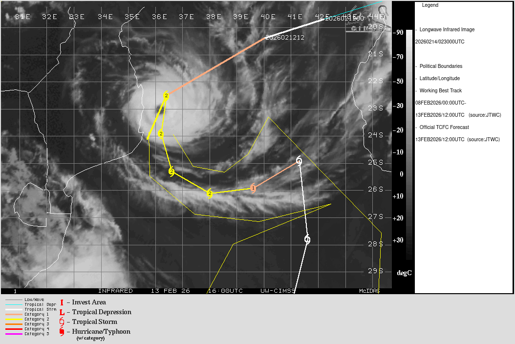
Updating the situation with Cyclone Gezani: as this infrared satellite loop from last night shows, the eye of the cyclone moved along the western edge of the cone of uncertainty from the Joint Typhoon Warning Center forecast. This resulted in the western eyewall passing over the coast of Mozambique near the port city of Inhambane (population ~80,000). While media reports of impacts here remain sketchy, the death toll in Madagascar from the cyclone has now risen to 40.
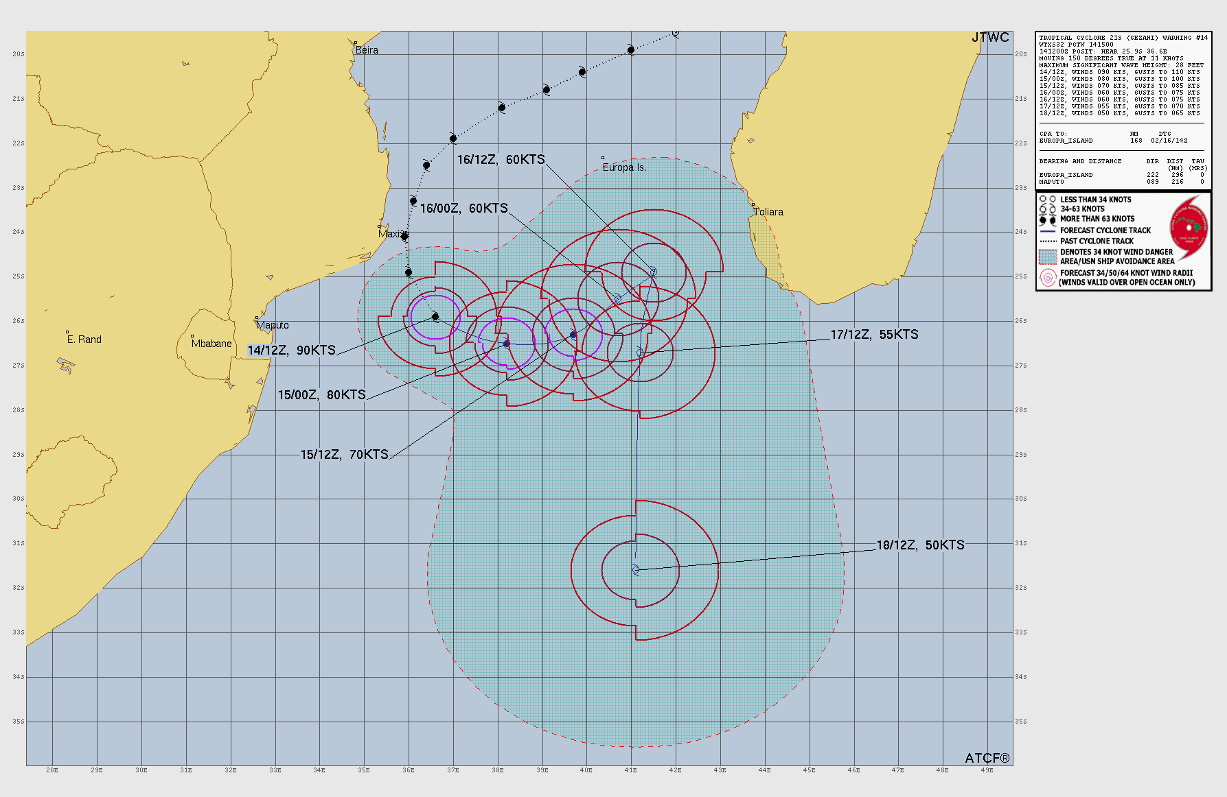
Gezani is now pulling away from the coast and should eventually turn south into the open Indian Ocean. Some of the ensemble forecasts do have it passing close to southern Madagascar as a tropical storm, though, so meteorologists in that region will obviously be monitoring it for potential impacts, primarily heavy rainfall.
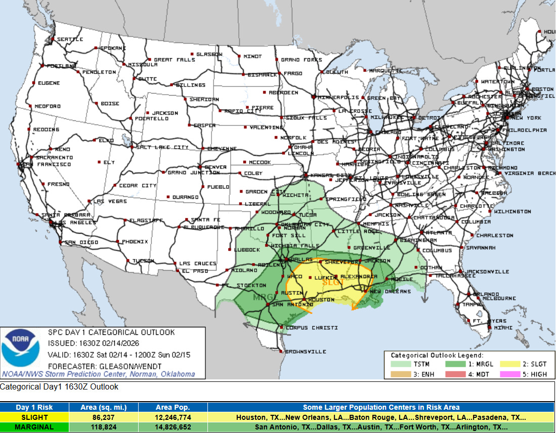
Stateside, in a sign that spring is not too far away, severe thunderstorms will be the primary weather story this weekend associated with the intensifying low pressure system moving east across the southern United States. A band of strong to severe thunderstorms is expected to organize over central and eastern Texas later this afternoon and move east overnight, with damaging winds and tornadoes possible with the most intense storms within the band. The risk should persist well into the night, and a slight (level 2 of 5) risk is in place as far east as southern Mississippi.
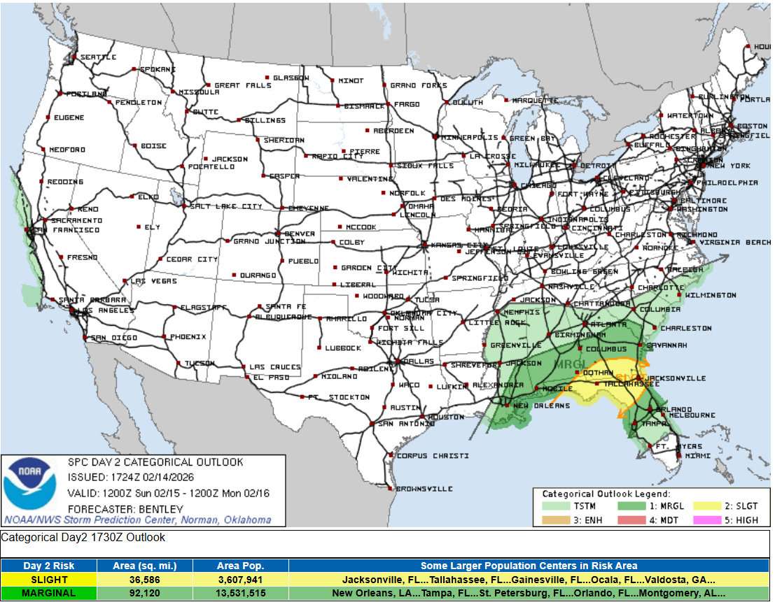
At some point toward sunrise Sunday, the band of storms should outrun the better low level moisture, which should result in the risk decreasing. However, strong wind shear in lower levels of the atmosphere will maintain some risk of damaging winds and a few tornadoes as the storms move across southern Alabama. By Sunday afternoon, it now appears the storms will again encounter better low level moisture coming north from the Gulf as they move east, and a slight risk is now in place from the Storm Prediction Center (SPC) for parts of the Southeast as shown above. Damaging winds and tornadoes will again be the primary threat — and in their forecast discussion, SPC mentioned the potential for a strong tornado given the strong low level winds forecast.

While the rainfall associated with this system will mainly be beneficial given the ongoing drought in many parts of the Southeast, there could be some localized flash flooding issues, particularly in parts of the Mid-South and Tennessee Valley where some training storms are possible.
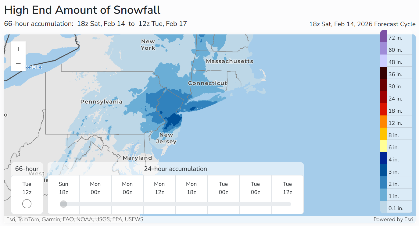
While nearly all of the precipitation associated with this system will be rain, the precipitation shield will encounter enough cold air for at least some light snow across parts of the Mid-Atlantic and Northeast . The reasonable worst case probabilistic snowfall forecast from the NWS Weather Prediction Center suggests that some 2-4” snowfall amounts are not out of the question in the areas shown above later Sunday into Monday.
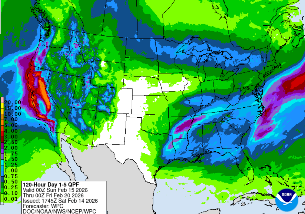
We are still expecting a series of storm systems to impact the West over the next several days, with California particularly under the gun for heavy rainfall and very heavy mountain snowfall.
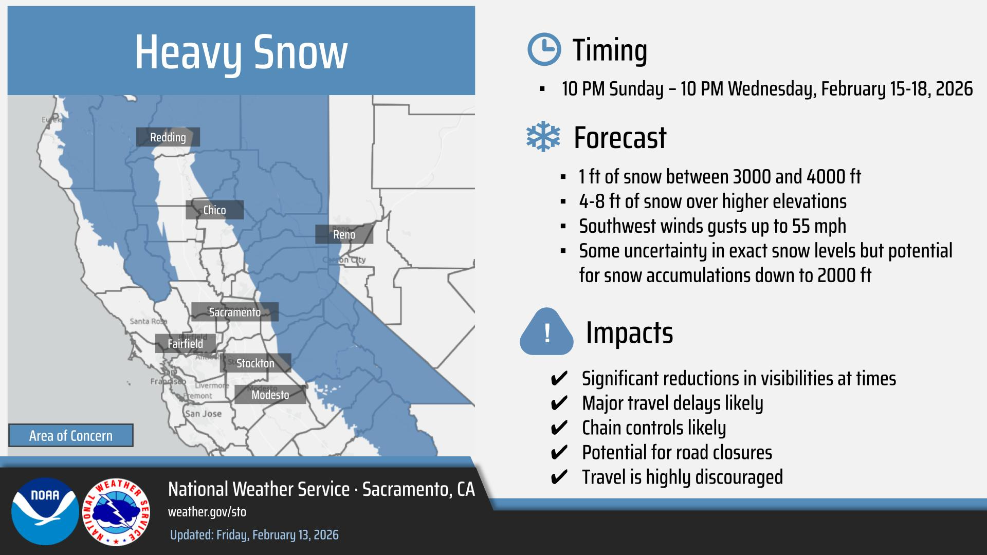
Monday into Tuesday still look like the most impactful period, with travel likely to become difficult to impossible in the Sierra Nevada.

Leave a comment