Thursday may have been the hottest winter day on record in the US, and I try to sort out some of the records
Feb 27, 2026
The weather community has been waiting for months to hear more about anticipated reorganization plans for the National Weather Service. The NWS has been under the same basic operational structure since the 1990s, and plans were already underway prior to the Trump Administration to make significant adjustments to said organization. Unsurprisingly, the staff cuts of the last year and the priorities of the new administration have resulted in agency leadership having to further examine and refine any plans.
However, the new organizational concepts appear to be coming into focus, and yesterday NWS leadership began to share at least some of the high level aspects of the potential changes coming to the agency with staff through an all-hands call. While specifics of the reorganization plan are not yet public, one aspect that was reported by Bloomberg and confirmed by the NWS is the disbanding of the NWS Climate Prediction Center and absorption of its duties into other parts of the agency.

The NWS National Centers for Environmental Prediction (NCEP) is a group of nine operational centers that provide national forecasts and warnings for particular hazard or service areas. The Climate Prediction Center (CPC) is based at the NOAA Center for Weather and Climate Prediction (NCWCP) on the campus of the University of Maryland-College Park, along with the Weather Prediction Center, Environmental Prediction Center, Ocean Prediction Center and NCEP Central Operations. CPC’s primary focus is on subseasonal and seasonal forecasts, producing daily national outlooks of week 2 temperatures, precipitation and hazards as well as monthly and seasonal outlooks.
While specifics of the CPC reorganization are unclear, Bloomberg reported that the bulk of the center will be merged into the Weather Prediction Center (WPC). This makes sense to me as much of what CPC does as far as producing outlooks and forecasts is a natural extension of the primary focus of WPC, the center responsible for national temperature, precipitation, winter weather and flash flood forecasts and outlooks for the week 1 period. It is important to recognize that (per Bloomberg) the CPC merger with WPC was something that was initially proposed as part of the initial NWS reorganization discussion back in 2023, so while this move may align with other administration priorities to reduce NOAA climate focus (e.g., the elimination of climate.gov) it was already under consideration before the new administration.
As I mentioned as the start of this post, this is just the first publicly known aspect of what is expected to be a significant reorganization of the nation’s primary weather forecast and warning agency. Obviously, as more details on these changes become public, I will be sharing that information along with my perspectives.

Turning to weather, record heat in the Southwest was a major story on Thursday. Falcon Lake, an NWS Cooperative Observation site along the Rio Grande in south Texas, reported a high temperature of 106F. While I cannot find an officialweb site or database to confirm this, multiple media sources are reporting that this would be the hottest temperature ever recorded in the United States so early in the year or at any time during the winter months (December through February).
From what I can see in the official climate records, it is the hottest February temperature on record for south Texas (and hence, likely all of Texas), breaking a 104F reading at Rio Grande City on February 26, 1902. However, my colleague Victor Murphy who used to lead climate services for NWS Southern Region before retiring, pointed out to me that there was a 107F maximum reported at a RAWS (fire weather) observing site near Rio Grande City on February 23, 2017. RAWS sites are typically not part of the official climate database and state monthly temperature records are not as rigorously kept as annual records, so it is tough to say if the 106F is “officially” the state or national record maximum for February or the winter. Regardless — it was hot, and especially for February!! Numerous other record warm maximum and minimum temperatures were reached in the Southwest Thursday, including a high of 103F at Laredo that tied their February record.
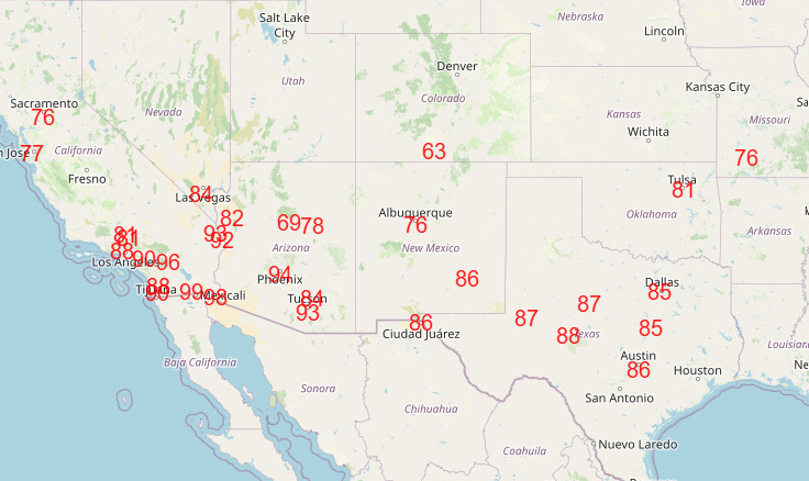
While the extreme heat that impacted south Texas on Thursday will retreat back into Mexico, record warmth is expected to continue to be widespread across the Southwest and parts of the Southern Plains through the early part of next week (forecast record high temperatures for Saturday shown above).
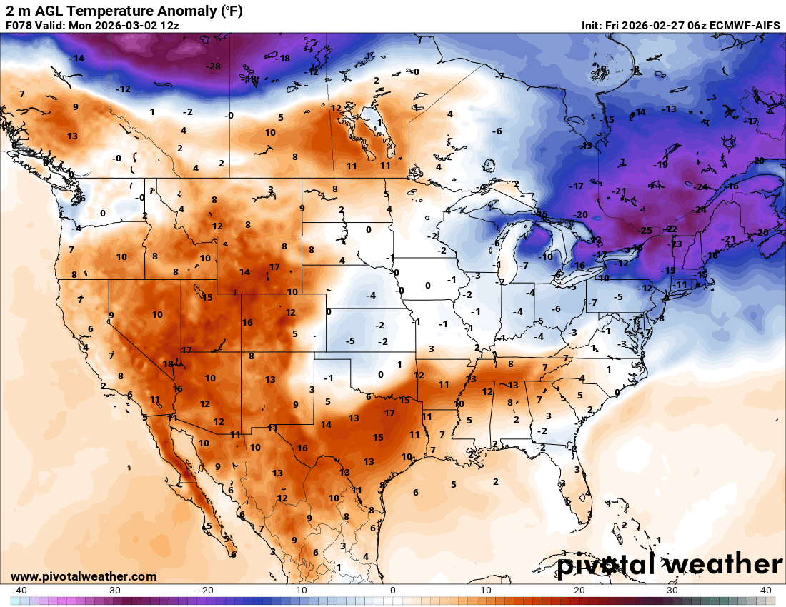
Meanwhile, one last shot of Arctic air will move into the Northeast late this weekend and into early next week before a definitive pattern change begins to evolve. Temperatures will be as much as 25F below normal in parts of New England Monday morning.

As part of the pattern change I mentioned, a system moving east across the Midwest and Mid-Atlantic should bring at least some minor impacts from snow and freezing rain, with the most likely areas to see some impacts in the Tuesday-Wednesday time period shown in the probabilistic outlook from the Weather Prediction Center above. Obviously that is still several days away and there is definitely some spread in the ensemble forecasts, so we will be keeping an eye on trends toward anything more significant.

The major upper level pattern change looks to become established by late next week, with a trough of low pressure developing over the Southwest while an unusually strong area of high pressure aloft builds over the East. This will result in a rather dramatic swing in temperatures for the East toward much above normal temperatures by next weekend. This should also bring some cooler weather along with rain and snow showers late next week to the Intermountain West and Southwest, although unfortunately this pattern does not look particularly wet for the region.
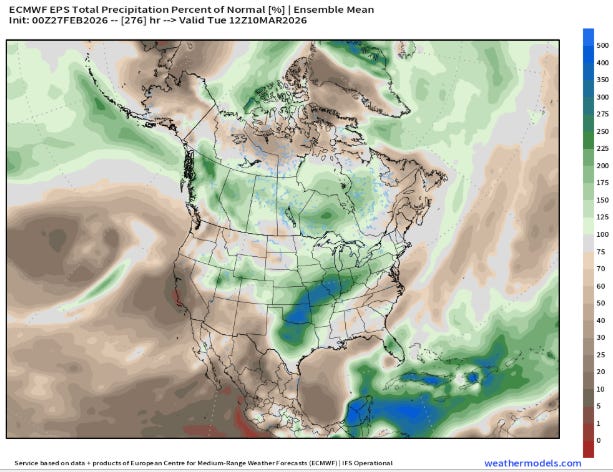
Where this pattern shift should bring a more definitive trend toward much wetter than normal conditions will be from the Southern Plains through the Midwest, where a series of disturbances should bring waves of rain and thunderstorms to the region starting during the middle to latter part of next week. Much of this region has been suffering from an unusually dry winter, so this will be welcome rainfall as we start to move into Spring.
However, this is also a classic pattern to bring increased severe thunderstorm risks to this same region — and indeed, the NSSL AI long range experimental severe weather probabilities suggest multiple days of severe weather risks for parts of the Southern Plains, Southeast and Midwest starting the middle of next week. As a reminder, I will be posting a video interview later today with Dr. Sean Ernst of the University of Oklahoma about the Storm Prediction Center’s new probabilistic severe weather outlooks that start next week.

Leave a comment