Cold winter in the East completely offset by warmest winter on record for many in the West
Mar 01, 2026
Happy March 1st! With the arrival of March, winter has ended as far as climatological statistics. As a reminder, while the first “official” day of spring does not come until the Vernal Equinox late in the month, for climate statistical purposes winter is tracked using the three months that are typically coldest, i.e., December through February.
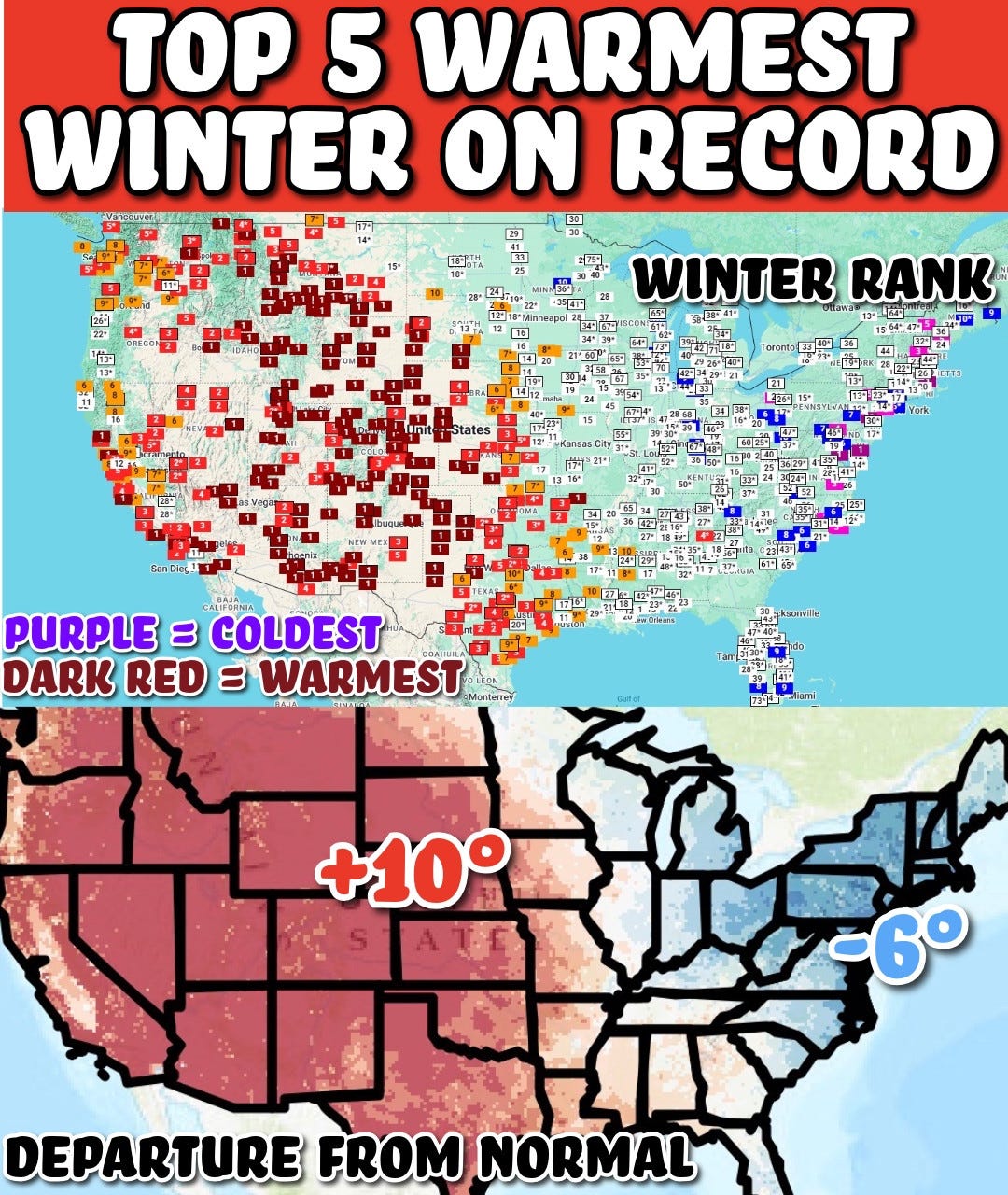
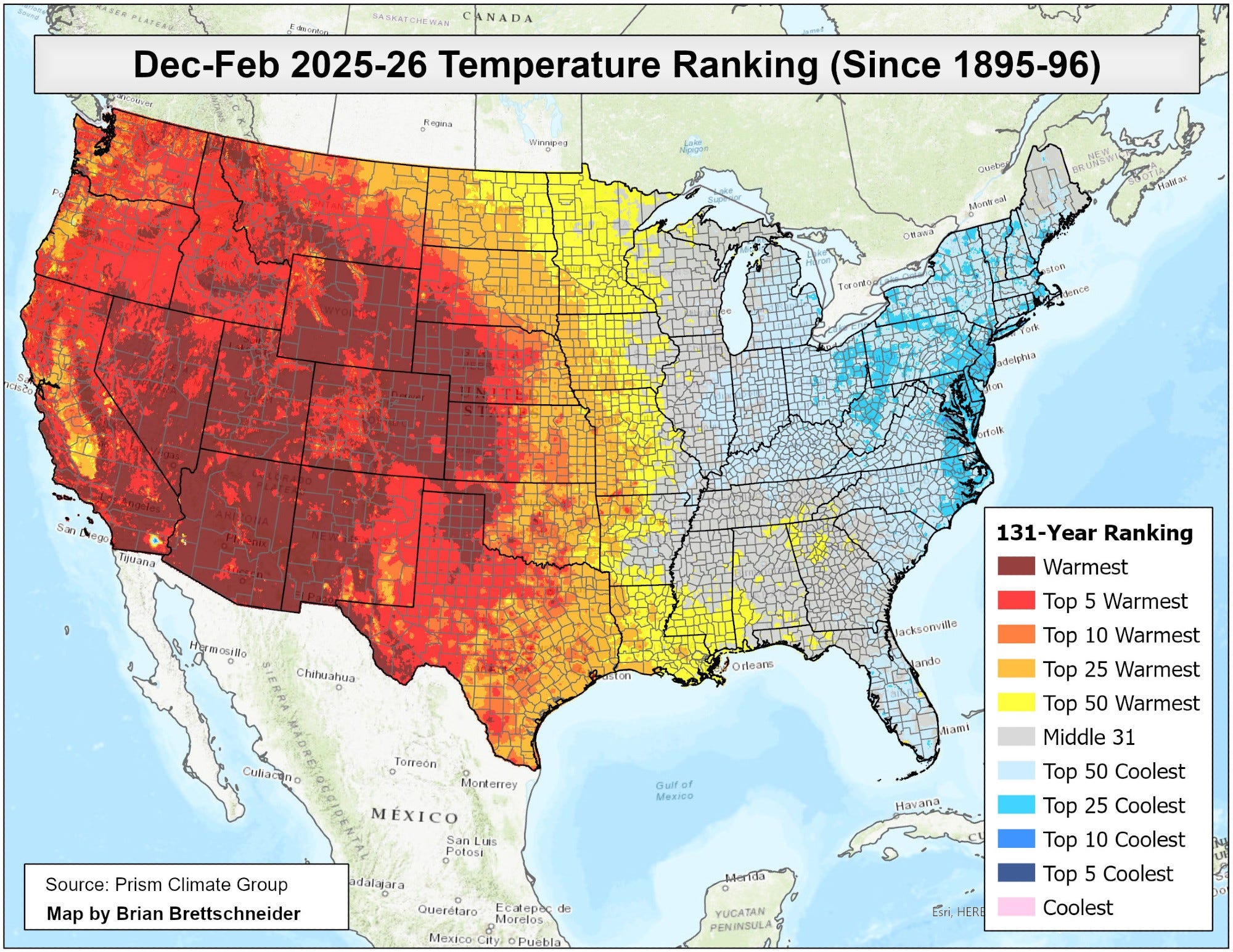
As this graphic posted on BlueSky by my colleague Jeff Berardelli shows, while most of the northeastern quarter of the country experienced a winter with well below normal temperatures, that was completely dwarfed by the western half of the country having well above normal temperatures. The magnitude of warmth was much greater than the magnitude of the cold as well. As you can see in the top map above, numerous locations in the western half of the nation had their warmest winter on record. Meanwhile, while the East was cold, for locations with long term climate records like NYC, Washington DC, Philadelphia and Boston, winter 2025-26 only ranked somewhere in the range of a top 25 to 50 coldest winters on record — it just seemed particularly brutal because of global warming and the trend toward milder winters in recent decades.
While it will be a day or two before we get final official statistics for winter rankings for the US and globe, climatologist Brian Brettschneider calculates that this winter will end up the 2nd warmest on record in spite of the cold in the East. We know that numerous long term climate sites in the western half of the country set new marks for warmest winter on record, including: Phoenix, Salt Lake City, Albuquerque, El Paso, Oklahoma City, Las Vegas, Tucson, and Lubbock.
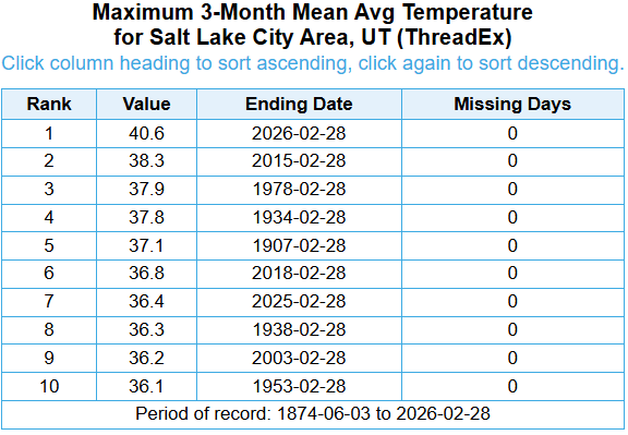
What is particularly impressive is the margin by which many of these records were established. A good example is Salt Lake City as shown above, which broke its winter record temperature by 2.3F. To give you perspective on just how unusual that is, you can see in the table that the entire difference between the second and tenth warmest average temperature is only 2.2F – so this winter exceeded the previous warmest winter by more than the margin of the difference between #2 and #10. Salt Lake City also set a new record for the least snowiest winter on record with only 2.5” of snow, breaking the previous record of 6” set in 2015.

Speaking of snow, as we head into spring, the snow water equivalent (i.e., the amount of water that would be realized from melting all the snow on the ground at a given location) is not surprisingly well below normal over much of the West. The northern Rockies and parts of the Sierra are the primary locations running near normal — but as my colleague Anthony Edwards pointed out yesterday, the Sierra are seeing rapid snowmelt due to the record warmth ongoing in California. He noted that the UC Berkeley Central Sierra Snow Lab reported their largest snow loss on record this week, with snow depth going from around 8’ on February 20 to less than 4’ on February 28. Luckily, some rainfall has helped offset the snowmelt so far.
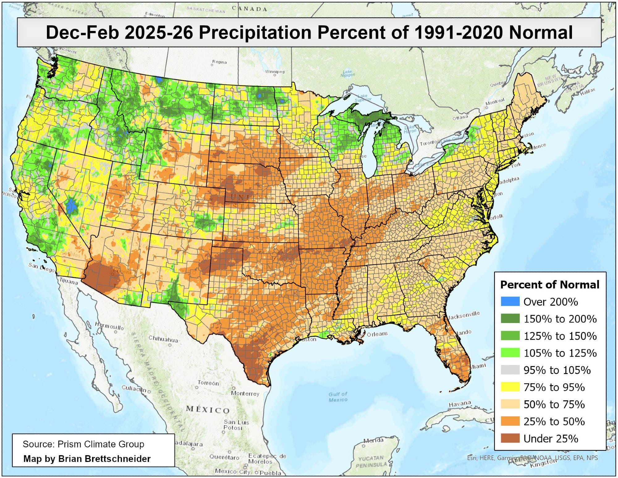
Overall, this winter has been very dry for most of the country, although not quite as dry as last winter’s driest on record as noted by Brian Brettschneider (who I again thank for his wonderful and important work performing these climate analyses and producing these excellent graphics).
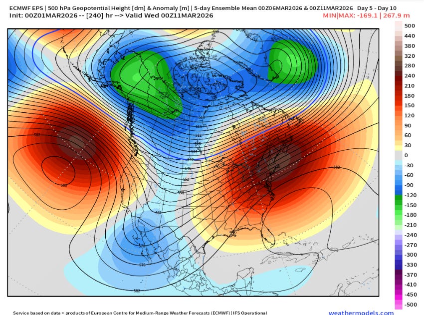
As we look ahead to the first half of March, a major pattern shift is looming as we have been discussing in recent days. This 500 millibar 5-day mean forecast for March 5-10 shows how the dominant middle and upper level atmospheric weather pattern will be shifting toward a trough of low pressure centered along the Rockies with an unusually strong downstream area of high pressure across the East.

Temperature wise, this is going to result in a trend toward of prolonged unseasonable and potentially record warmth across the East once the Northeast gets past the last shot of Arctic air expected the next couple of days.
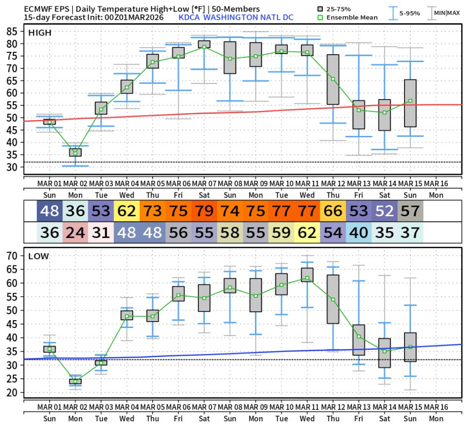
This can be seen in this forecast temperature graphic from the European ensemble model for Washington, D.C. which shows a 10 day period of well above normal temperatures, including a week with temperatures well into the 70s and approaching 80F at times. It does look like in the very long range some trend toward colder air spilling back into the East — and given the magnitude of cold air still locked up over Alaska and parts of Canada, winter may not be over for parts of the US quite yet.

This pattern will also result in a flip toward wetter and stormier than normal conditions along the Interstate 35 corridor from Texas to Missouri and east through the Ohio Valley. Overall this is a very welcome development as this area has had an extremely dry winter as can be seen in the winter precipitation map above. However, we will need to keep an eye out for an enhanced risk for severe thunderstorms and eventually flash flooding as this is a classic pattern to see those hazards.
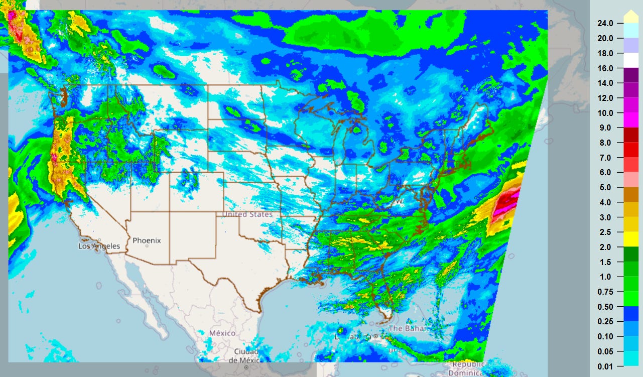
Unfortunately, this weather pattern is not particularly wet for the Southwest or the Southeast, both areas that could use more precipitation. Luckily, parts of the Southeast including Florida did pick up some helpful precipitation over the last week but plenty more is needed. Obviously, the Southwest was bone dry again the last week and not much is on tap west of Texas for the foreseeable future.

Leave a comment