Active weather expected across the central US this week
Mar 02, 2026
Happy Monday! With climatological winter coming to a close with the end of February, there will continue to be news and stories over the next several days about the final statistics for Winter 2025-6. Along those lines, today I want to highlight the work of Dr. Jonathan Martin, a professor in the Atmospheric and Oceanic Sciences Department at the University of Wisconsin.
Jon has done groundbreaking work over the years on the structure of winter extratropical cyclones, and one of his ongoing projects as part of his research has been tracking the size of the winter “cold pool.” Meteorologists have long used the 850 millibar (mb) level (about 5,000 ft AGL) as the level in upper level balloon data to analyze the thermal qualities of low level air masses. What Jon does with his tracking is to use the 850 mb temperature analysis from the US Global Forecast System (GFS) model to compute at 6 hour intervals the area of the Northern Hemisphere where the 850 mb temperature is at least -5C or colder, which he defines as the hemispheric “cold pool.” By monitoring this feature, we are not tracking temperatures at given localized points on the surface but rather are able to examine, for lack of a better phrase, the total volume of cold air that exists across the hemisphere.

Jon has retrospectively calculated the cold pool size using the same methodology for each winter all the way back to 1948-9, enabling him to track how this winter’s cold pool compares to previous years. In the graphic above, the size of this year’s cold pool is the red line, while the thick blue line is the mean cold pool size with gray shading surrounding the line signifying 1 standard deviation from the mean. The thin blue lines for each day represent the range in the size of the cold pool for each day in the database back to 1948.
You can see very quickly in this visualization how unusually small the hemispheric cold pool was this winter. Most days it was below the 1 standard deviation line, and it only even reached the (nearly) 80 year average on one day of the winter. Seven days set a daily record for smallest cold pool. Indeed, Jon states that if you look at the integrated departure from normal over the entire 90-day period, that winter 2025-6 is the warmest winter back to 1948-9 based on the cold pool size parameter.
Work such as this enables scientists to monitor climate change at a more global level, and what is alarming about Jon’s work is that the winter of 2025-6 is not a particular anomaly as far as recent winters. In fact, he notes that of the last 12 winters, three set all-time records for smallest hemispheric cold pool size, and a fourth year barely missed setting a record.
I wanted to share Jon’s important work because I think it is a great illustration of how climate is very different from what a particular individual observes as far as the weather at their location. Research such as this enables scientists to look at the planetary atmosphere as a whole — and like so much other scientific work in recent decades, it tells the undeniable story that our planet continues to warm unabated.

Speaking of warmth, Sunday was yet another day of record warmth across the southwest quarter of the country, with numerous daily records set.

This week will see this record warmth expand and gradually shift east as the advertised change in the pattern to an upper level trough along the longitude of the Rockies with an anomalously strong ridge of high pressure downstream over the East.

By late in the week, record high temperatures are forecast to be widespread across the southeastern quarter of the nation (forecast record highs for Friday shown above).
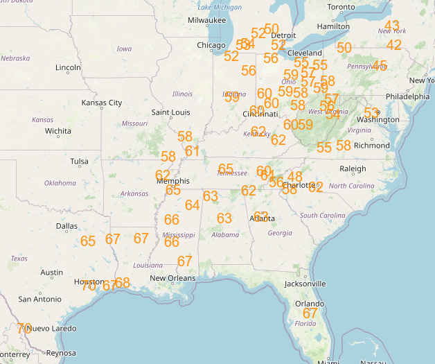
Record warm minimum temperatures look to be even more expansive as unusually moist air flows north from the unusually warm western Gulf of Mexico and combines with the unseasonably warm air. As shown above, by Saturday dozens of record warm minimums are expected from the Gulf Coast to the Great Lakes.

All signs are that this will be a prolonged warm spell, with warmth only expected to build across the Mid-Atlantic and Northeast into the middle of next week.

However, as I mentioned yesterday, by mid-March there continues to be signs in the models of an unusually cold airmass building over Canada that starts to seep south and southeast — so we may not quite be done with winter yet. Obviously, though, as we get later into March, normal temperatures are on the rise and truly bitterly cold air becomes much more difficult to get south into the US.

As far as precipitation and storminess, an active pattern still looks to be setting up from eastern Texas northeast into the Ohio Valley this week, as multiple upper level disturbances move northeast and interact with that Gulf moisture, resulting in waves of showers and thunderstorms that will produce heavy rainfall. Again, with ongoing drought conditions over most of this region, this rainfall will overall be beneficial, but there could be some localized flash flooding issues where the most intense short-term rainfall occurs.
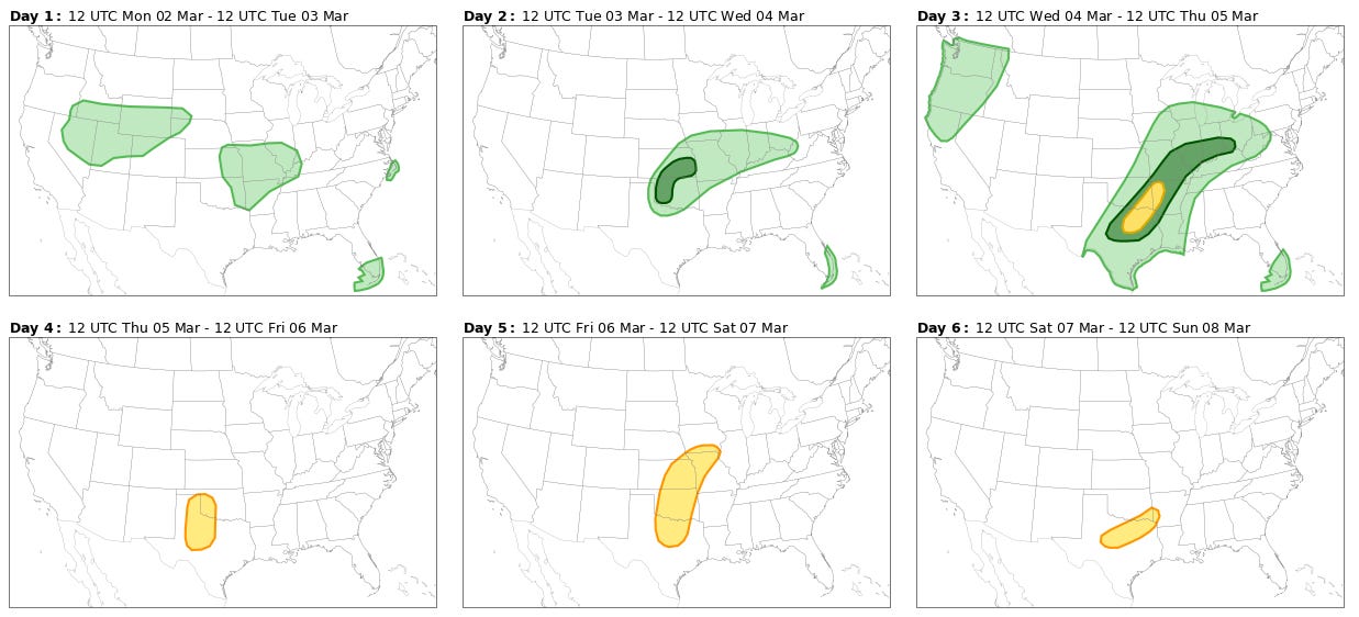
This pattern is also generally favorable for severe thunderstorms, and the Storm Prediction Center has risks outlined the next several days as the various atmospheric disturbances move through the south-central US (green=marginal 1/5 risk; yellow=slight 2/5 risk). As of now, though, there does not seem to be much support for any day with a particularly higher end severe weather threat.
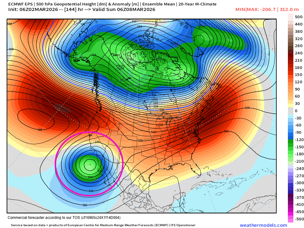
Part of the reason for the lack of a higher end severe threat is that there has been some evolution to the expected pattern in the longer range. Instead of a persistent upper level trough over the Rockies, it now looks like the southern portion of the upper level trough will break off and form an upper level low that will drift west to off of Baja California by this weekend. This means instead of any particularly intense storm system coming out of this pattern, it is more likely that we will just see the passage of weaker disturbances this week followed by a period of drier and less active conditions the first part of next week.

Leave a comment