In weather, significant outbreak of severe storms and potential intense tornadoes expected today, focused on lower Great Lakes region
Mar 10, 2026
Lots of weather to talk about today, but need to start off by highlighting some news that broke last night related to the National Center for Atmospheric Research (NCAR) and the Trump Administration’s announced plans to dismantle the NSF supported research center.
As part of the process of its planned “reorganization” of NCAR, NSF issued a “Dear Colleague” letter asking for input from the scientific community about the future organization of NCAR. Late yesterday, Rep. Joe Neguse (D-CO), who represents the Boulder area where the main NCAR research facilities are located, released a letter that he sent to the NSF Office of the Inspector General regarding NCAR. In the latter, he reports being contacted by a whistleblower who alleges…
that one or more OMB officials allegedly proposed and/or negotiated — before the NSF DCL (ed. note, dear colleague letter) process had concluded — an arrangement whereby components of NCAR’s space weather program would be transferred to a specific private, for-profit company. According to the report, the allegation was purportedly confirmed by an individual employed by the same for-profit company during a recent meeting of the American Meteorological Society in Houston in January of this year.
Obviously, there are many potentially serious legal and ethical issues raised by this accusation — not the least being (as Rep. Neguse notes) that current laws require space weather research to be conducted by NCAR, not private companies. Furthermore, I think it is far to say that many in the atmospheric sciences community were already very skeptical about how serious NSF actually is about obtaining and/or using community input about NCAR, and this report will obviously only amplify these concerns.
Neguse is asking the OIG to conduct a formal investigation:
The federal DCL process is not a mechanism for reaching pre-determined outcomes nor for selling or awarding federal programs to private companies, and it cannot be used to bypass the law and hand federal programs to preferred private companies without undergoing competitive merit-review processes. In this instance, if allegations of a predetermined transfer or selloff were proven to be true, it would clearly violate the spirit and letter of the “Dear Colleague” process and likely violate Federal law. Therefore, it is vitally important that your office investigate the same. I remain deeply concerned about any attempts to improperly transfer public assets to private companies. As the independent oversight office for the National Science Foundation, I believe it is your duty to investigate the allegations detailed herein and to put an immediate end to any such activity. Thank you for your full and fair consideration of this matter, consistent with applicable statute and agency guidelines.
Axios notes in their story on this new development that the reached out to administration officials for comment but had not received anything. Obviously, more to come on this continually evolving situation surrounding NCAR.
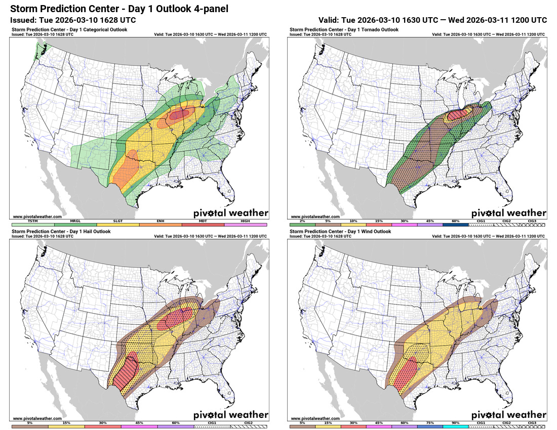
Turning our attention to the weather, unfortunately the severe weather risk has continued to trend more ominous for today, particularly in the northern of our two areas of concerns where the NWS Storm Prediction Center (SPC) now has a moderate (level 4 of 5) risk in place.
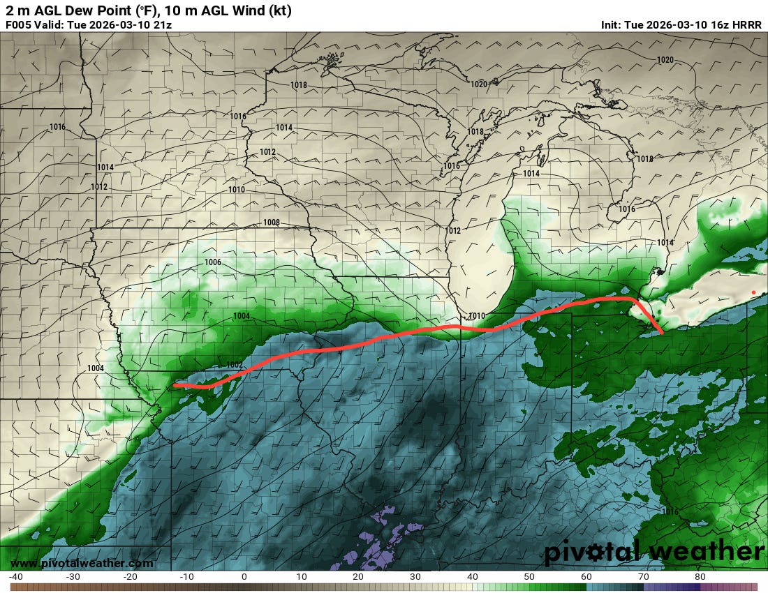
As has been the case several times in this recent spate of severe weather, a warm front looks to be the primary focus for severe weather in this region today. As an upper level weather disturbance ejects northeast and interacts with the unusually warm, moist and unstable air south of the front waves of strong thunderstorms will develop and move east-northeast in the vicinity of the front. Conditions will be favorable for supercell severe storms with all modes of significant severe weather, and as we get into later in the afternoon and this evening, low level wind shear will further increase yielding conditions very favorable for tornadoes, particularly along the warm front.
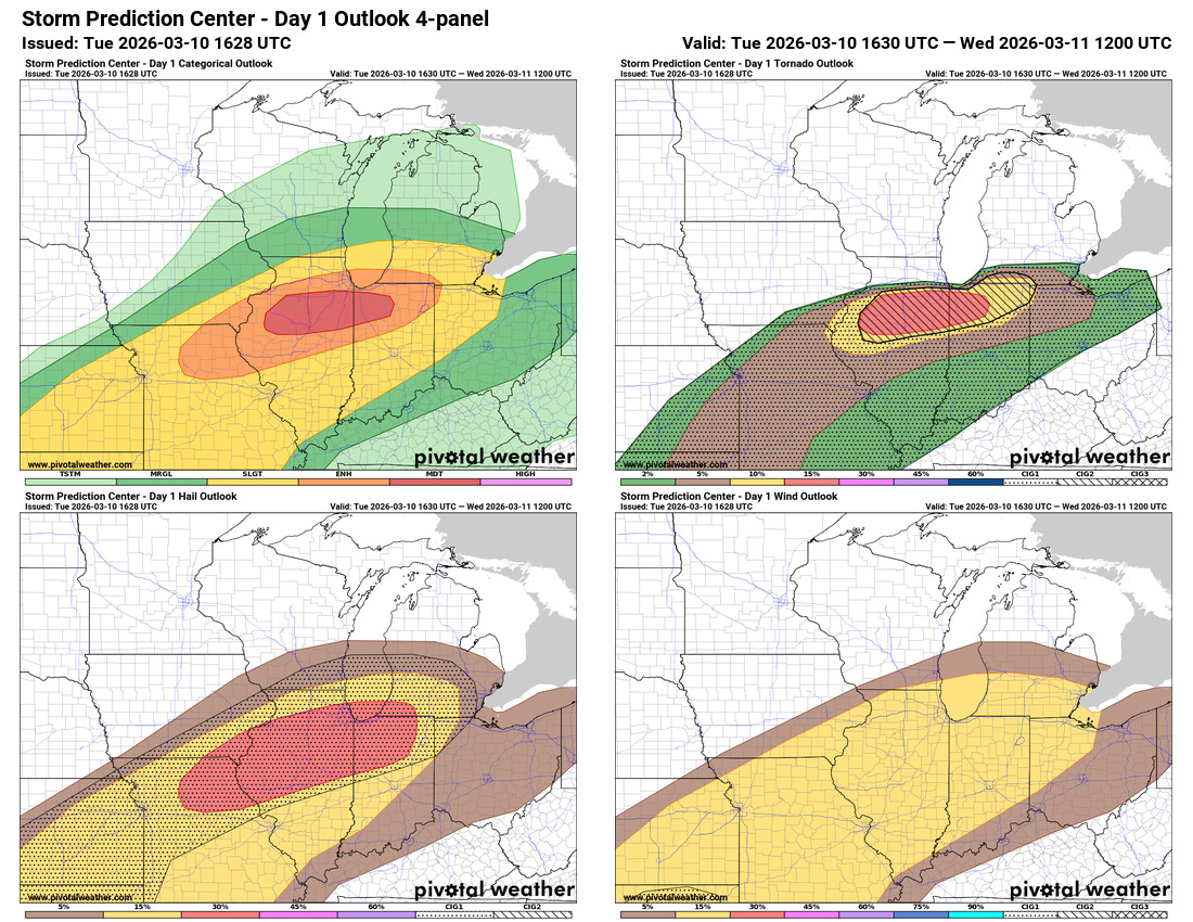
This overall weather situation is a classic setup that has historically produced significant tornadoes in this region, and SPC for the first time used their “CIG2” conditional intensity area across northern Illinois and Indiana as well as extreme southwest Lower Michigan. The means there is a potential for long tracked, intense (EF3+) tornadoes in this region.
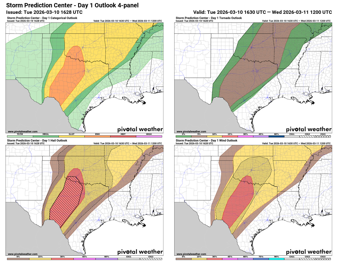
Farther to the southwest, additional bands of supercell severe thunderstorms are expected across Texas and Oklahoma as the upper level low that has been spinning off of Baja California moves east and interacts with the very unstable air in place. Very large hail and significant wind damage could occur with the most intense storms in this region, and while the tornado risk is not as focused or high end as the region over the Midwest, there is still the potential for a few strong tornadoes in this area as well.

Intense rainfall rates with these storms could also cause some localized flash flooding, with more focused risks of flash flooding along the warm front in the Lower Great Lakes and over parts of eastern Texas.
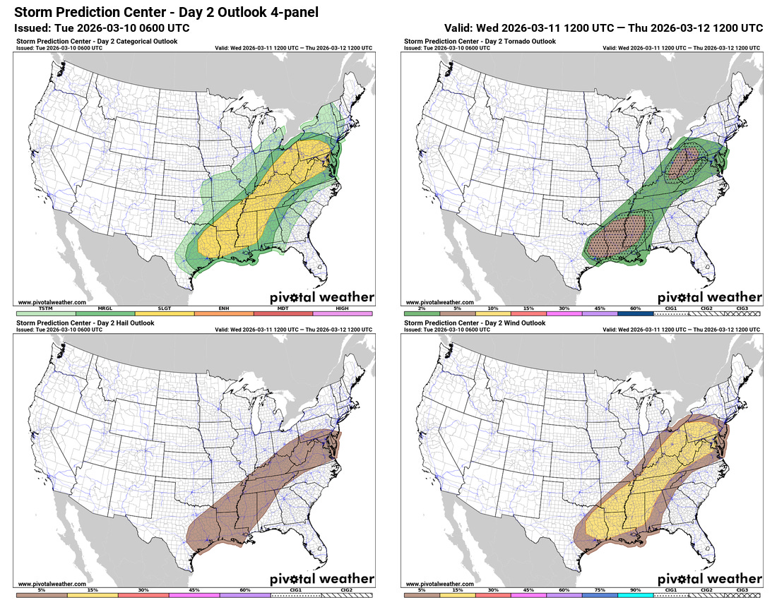
Additional severe weather is expected Wednesday and Wednesday night as the front slides east. As of now, SPC has a large slight (level 2 of 5) risk along the front. Some of the AI guidance is more aggressive with the severe weather risk tomorrow — but as I have mentioned in earlier posts, this severe weather threat actually looks more like a risk later in the season that will be modulated by how the atmosphere evolves at smaller scales due to thunderstorm evolution. This means that the areas most at risk for higher end and focused areas of severe weather will be rather dependent upon what happens with thunderstorm activity today. Hence, identifying those areas will be more challenging and will be waiting for later updates as the day 1 SPC outlooks come out.
I will be providing social media updates later today about the evolve severe weather risks, and depending on how things develop may start a live video and/or Substack chat session to give “play by play” on the severe weather threat. Additionally, I am planning to use the Substack Chat feature more going forward to just share quick thoughts and updates about what I am seeing in recent data. As a reminder, live videos and chats are benefits for paid Balanced Weather subscribers.

Leave a comment