Universities and private entities vie to take on various NCAR programs
Mar 12, 2026
Strap in, long post today as there is a boatload of weather to talk about today, including a number of major impending events that I have had to push to the back burner given the imminent significant severe weather risks the last few days. Before I jump into all of that, though, I wanted to highlight an article published by Science yesterday that provides behind the scenes details on the ongoing effort by the Trump Administration through the Office of Management and Budget (OMB) and National Science Foundation (NSF) to dismantle the world renowned National Center for Atmospheric Research (NCAR).
The article goes into the details of the responses that NSF has received from its “dear colleague” letter call for community input on their plan to dismantle the lab, as well as specific proposals from any entities interested in potentially taking over various aspects of NCAR.
The National Science Foundation (NSF), which funds NCAR, quickly followed OMB’s directive, soliciting bids to take over management of NCAR’s various components from the University Corporation for Atmospheric Research, a nonprofit consortium of more than 100 universities. NSF has received a flood of responses, many of them simple protests from scientists. But serious ideas are on the table.
The University of Wyoming (UW), at NSF’s request, will propose taking over an NCAR supercomputing center in Cheyenne. NSF is expected to move two NCAR-operated research aircraft to either NASA or NOAA. And this week, proposals are due to NSF for reconfiguring or dispersing the heart of NCAR—Boulder’s Mesa Lab, the striking building that is home to most of its 800 scientists and engineers. For decades they have researched how storms form, how seasonal weather can be predicted, and how the world will change with the warmer temperatures to come. Science has learned that one proposal is expected to come from the University of Oklahoma, an academic powerhouse in severe weather research. Another will likely come from Lynker, a NOAA contractor that wants to take over NCAR’s space weather research. The details of the bids are sparse, but atmospheric scientists hope any new scheme will preserve NCAR’s functions and expertise.
One of my main concerns about all of this that an entity like NCAR is more than just the sum of its parts. The Mesa Lab is truly a world-renowned facility that is home to some of the field’s most important research projects and talented scientists. There is a synergy that exists by having science efforts from across the spectrum of weather and climate science in a single location. Even if the individual parts of NCAR’s work are fully maintained, once that synergy is lost it can never be recreated in my opinion, and that would be a tremendous loss for atmospheric science and truly for science in general.
The article notes that plenty of potential obstacles to the administration’s plans for NCAR exist, including that the Mesa Lab land was donated by the city of Boulder specifically to NCAR and NSF and that could limit any effort by OMB to sell the building. And as I have discussed many times in prior articles on this subject, Science notes that political issues that have little to do with science may be at play:
NCAR’s climate research may not be the only thing driving the White House attack. It is widely believed to also be part of a campaign of political retribution waged against Colorado for its conviction and imprisonment of Tina Peters, a former county clerk who breached election security systems in a scheme to find proof of fraud in the 2020 presidential election. The state has included the attack on NCAR in a lawsuit against the Trump administration. But last week, Colorado’s Democratic governor, Jared Polis, floated the possibility of commuting Peters’s sentence in a social media post. Given Trump’s transactional views on politics, such a move could soften the administration’s views of NCAR. The proposal from Polis drew widespread outrage from state Democratic leaders. But Polis, who is from Boulder and has close ties to NCAR, has been known to buck his party in the past. The fate of one of the world’s most famous climate labs may hinge on backroom bargaining far removed from atmospheric science.
Learn about other BalancedWx Services
Much more to come on all of this, of course, but I want to turn my attention to the incredibly busy (and in some cases, downright insane) ongoing and expected weather happenings. I will undoubtedly be doing some deeper dives on some of these events in coming days, but for now will just try to hit the various highlights to raise awareness.
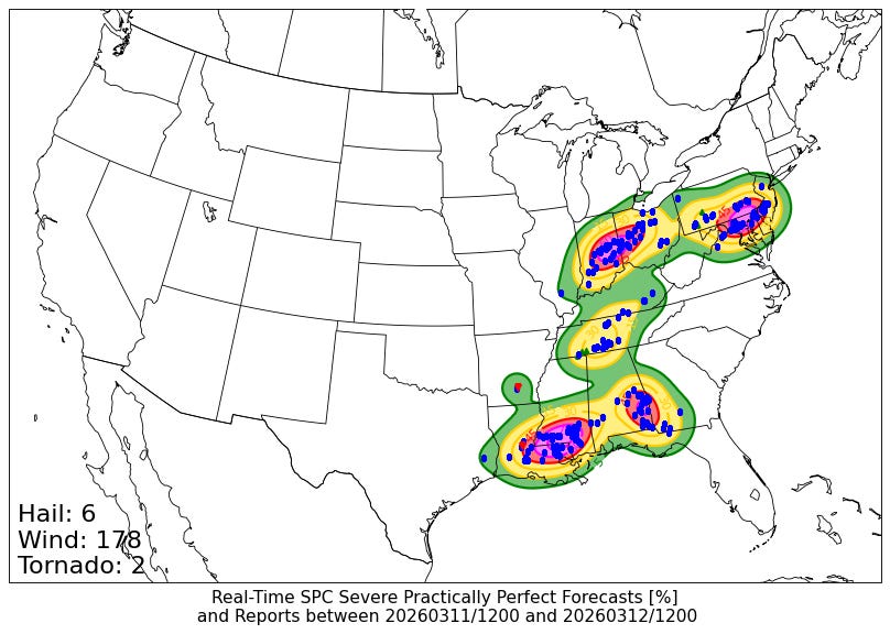
First, a quick recap on yesterday’s severe weather. Several bands of severe storms move east ahead of the cold front that continued to sag its way southeast. Nearly 200 reports of severe weather were received by the Storm Prediction Center, mostly (as expected) damaging straight line winds – though some of these wind damage reports will likely end up being confirmed as the result of tornadoes once NWS damage surveys are conducted.
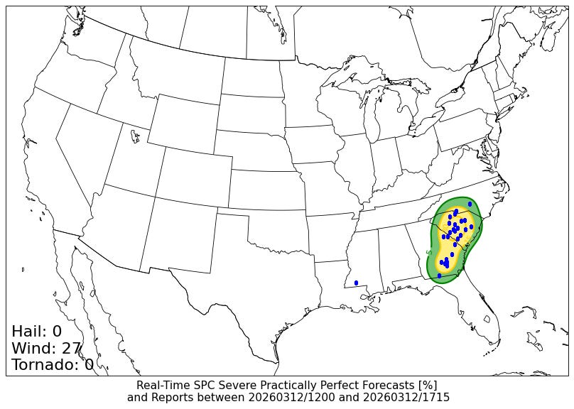
As I talked about in yesterday’s post, the line of severe storms got its act together along the central Gulf Coast region late yesterday afternoon, and worked its way east overnight into Alabama and Georgia, and has been producing additional incidences of wind damage this morning as it moved toward the coast.
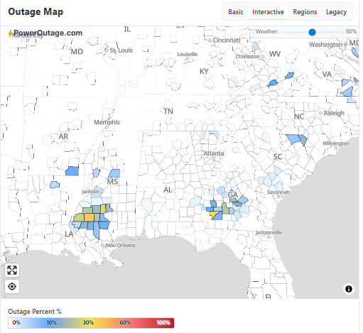
Significant power outages resulted from strong wind gusts (and likely a few tornadoes) as the line moved across southern Mississippi and the Florida Parishes of Louisiana last evening, with nearly 90,000 customers without power at the peak (~45,000 remain without power currently). More than 25,000 customers have lost power in Georgia due to the storms.
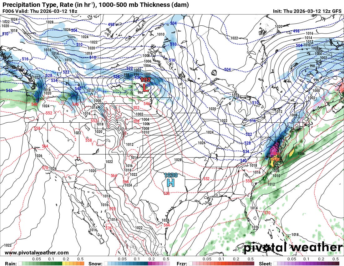
As the cold front that has been the focus for so much severe weather the last few days finally slides off the East Coast after a few more hours of severe weather risk in the eastern Carolinas, colder air is filtering in behind resulting a brief changeover to snow in some areas. Meanwhile, a new intense storm system is moving across the Northern Plains, bringing wintry weather to many areas as well as widespread issues with high winds over a large swath of the northern half of the country.
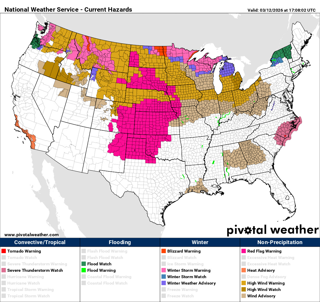
High wind warnings and wind advisories are in effect for most locations from the Pacific Northwest through the Great Lakes region. Additionally, dry air and ongoing drought conditions will combined with the strong winds to produce dangerous wildfire conditions across much of the Plains, and Red Flag Warnings are in effect. Heavy snow combined with the strong winds is resulting in winter storm and blizzard warnings for many locations in the US/Canada border region from the Pacific to the Great Lakes.
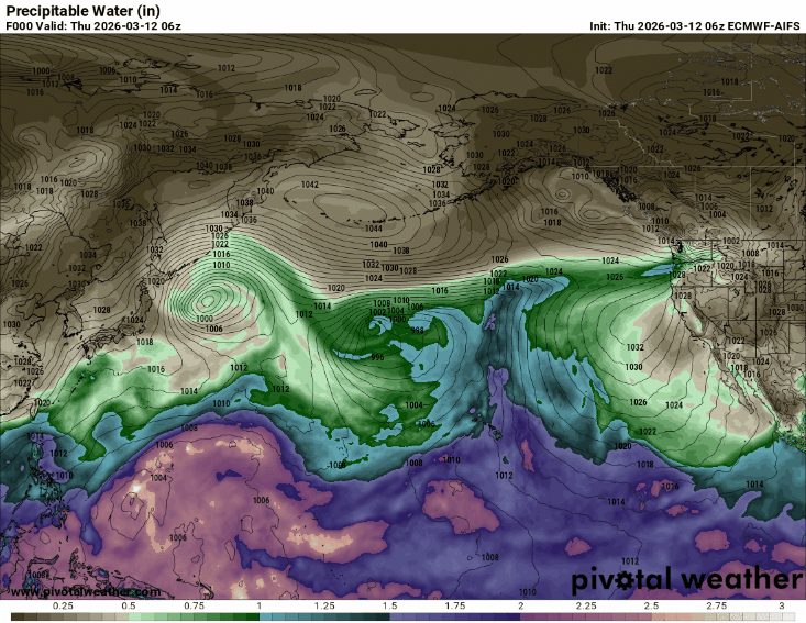
The storm system over the north central US today is part of a series of storm systems and associated atmospheric rivers of moisture that will be impacting the Pacific Northwest in a pattern somewhat reminiscent of the atmospheric setup that brought historic flooding to western Washington in December. Luckily, as of now this pattern does not look nearly as wet, although some at least minor river flooding is expected on some river basins here.
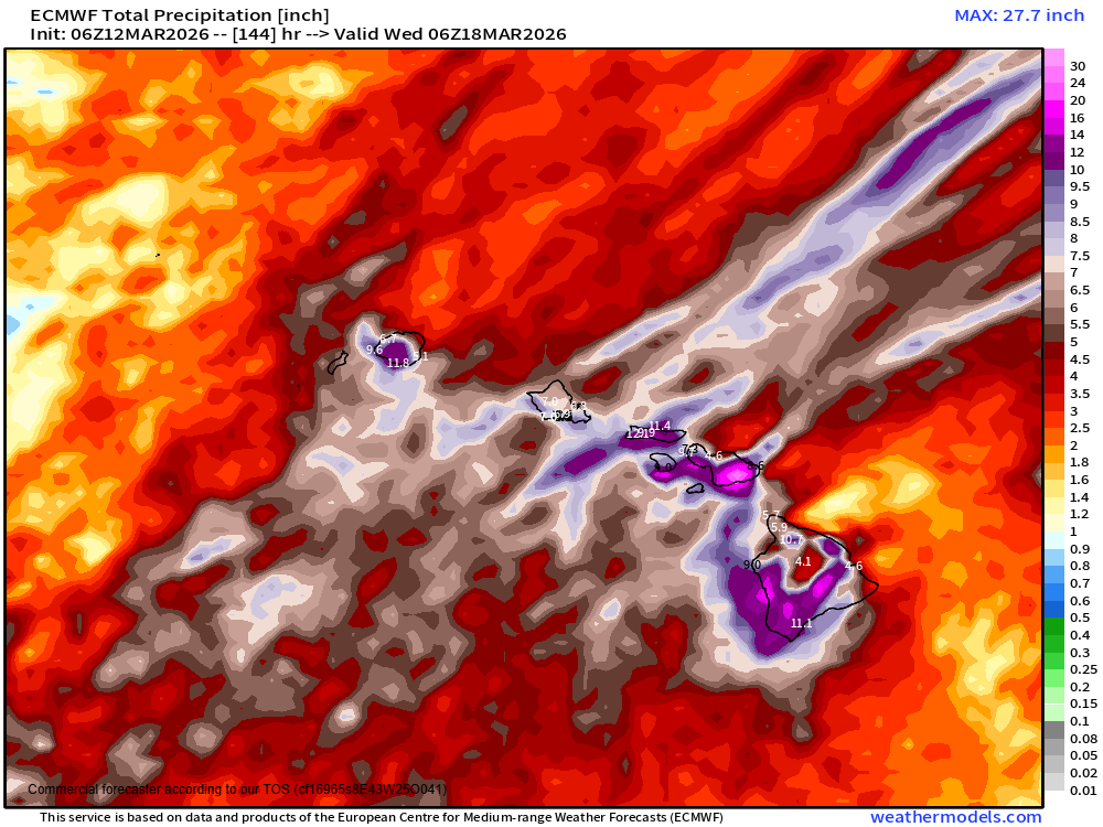
If you look closely at the animation of precipitable water above, along with the parade of moisture into northwest North America, you can also see a plume of precipitable water values greater than 2” flowing continuously across Hawaii from the southwest through early next week. This prolonged “Kona low” pattern is expected to bring significant — and potentially life-threatening — heavy rainfall and flash flooding to the state, including to the normally “dry” leeward sides of the islands as shown in this rainfall forecast from the European model. Damaging high winds and an unusual risk of severe thunderstorms and waterspouts are also expected to impact the state the next several days.
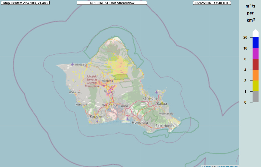
In fact, heavy rainfall has been occurring the last several hours across O’ahu, and a flash flood warning is in effect for the island. The MRMS FLASH unit streamflow hydrologic product shows inundation values as high as 10 — indicative of potentially significant flash flooding — in parts of central O’ahu currently. Much more rainfall is anticipated in the coming days.
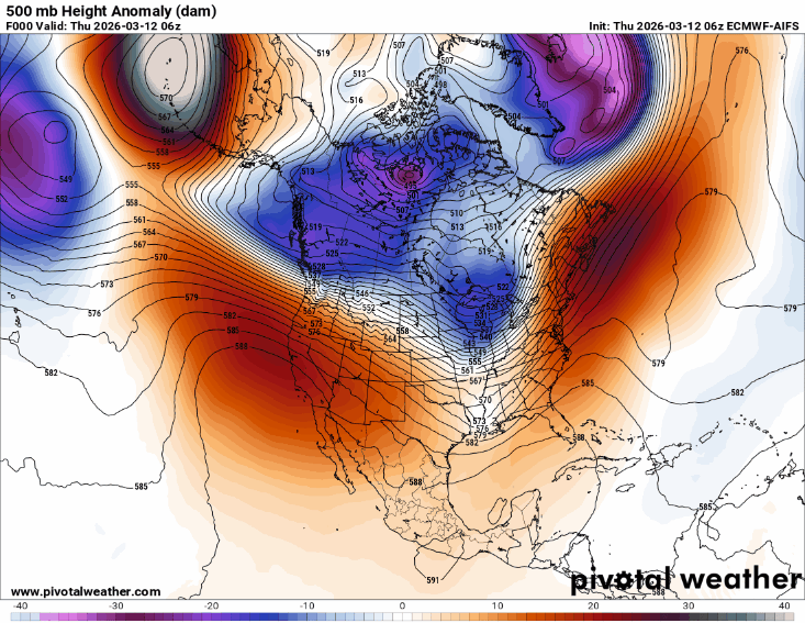
All of this wet weather is occurring on the west and northwest side of an incredibly strong middle and upper atmospheric area of high pressure over the eastern Pacific that is expected to build and peak in intensity near record levels for the time of year across the western United State next week.
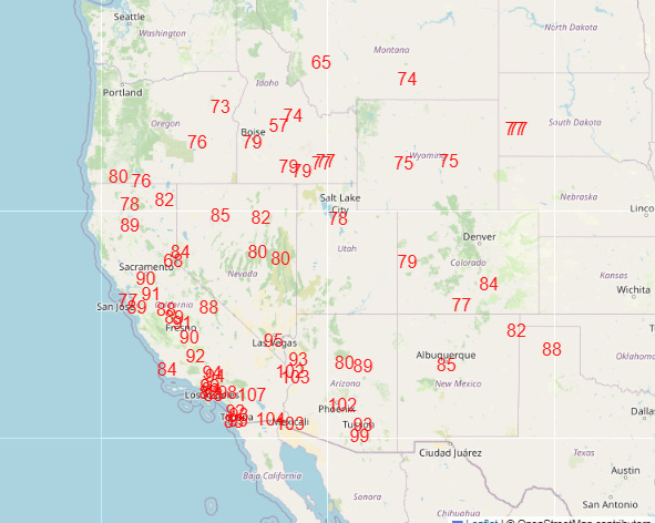
This pattern will bring days of record warmth to the western half of the country, which is expected to peak with unprecedented March warmth the middle and later part of next week (Wednesday forecast record high shown above). Many locations in the Southwest look likely to break all-time monthly record highs for March by several degrees and potentially on multiple days.
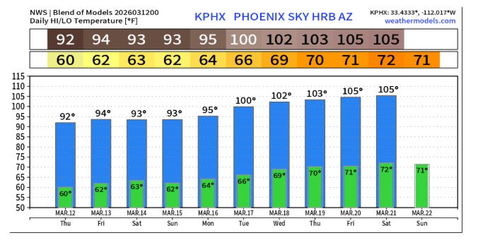
An illustrative example is Phoenix, where the all-time record high for March is 100F set on March 26, 1988. The current NWS model blend forecast shows at least five consecutive days at or above this reading next week.
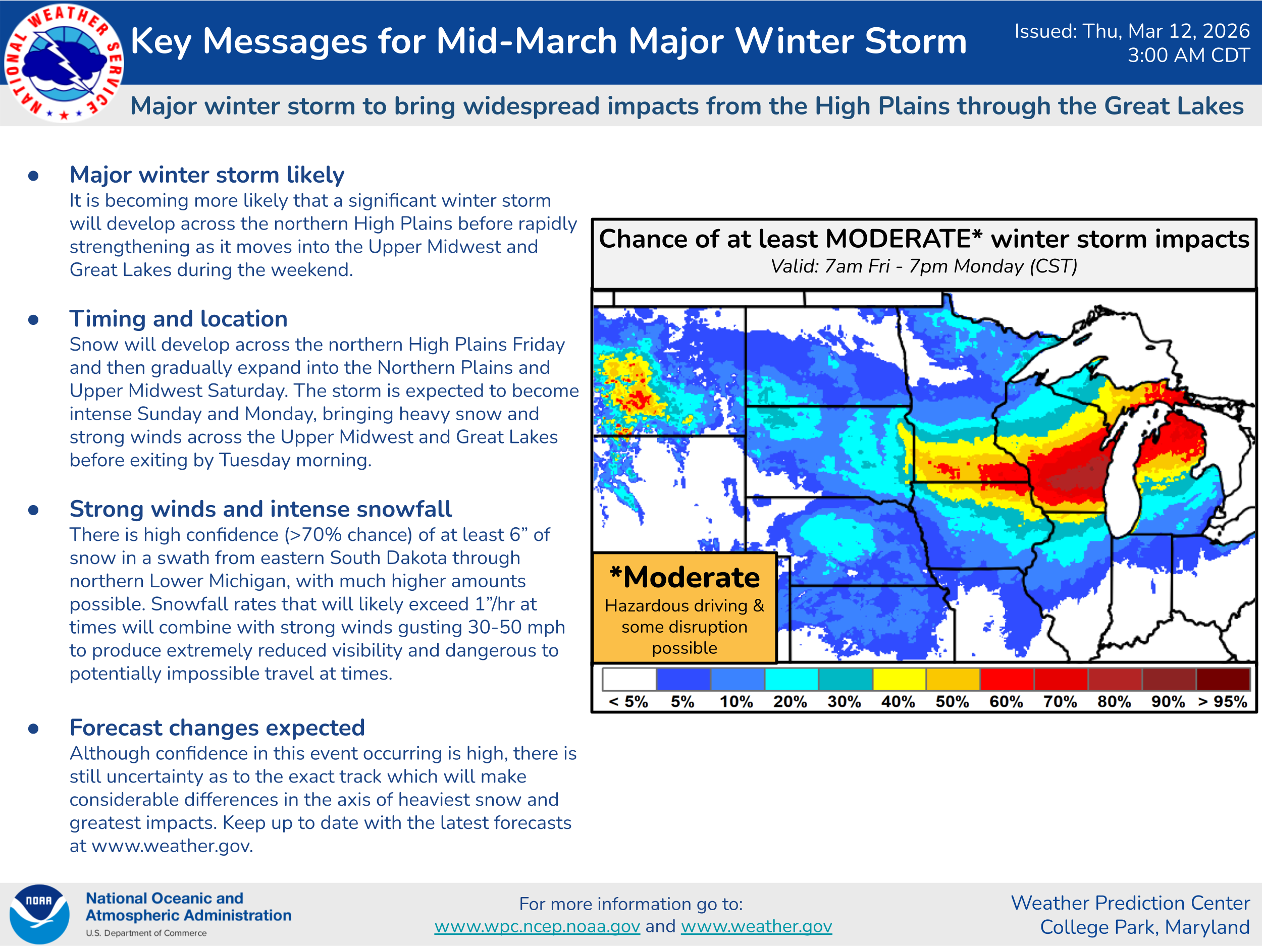
As if all of this were not enough, downstream of this record strong upper level high pressure system, an intense upper level storm system is expected to drop southeast across the central and eastern United States this weekend. There is still some uncertainty in model forecasts, but as shown above in the probabilistic winter storm severity index graphic from the Weather Prediction Center a high likelihood of heavy, wind driven snow exists across the upper Midwest and Great Lakes. Very heavy snowfall totals well in excess of a foot and blizzard conditions with near impossible travel will be possible in some areas.
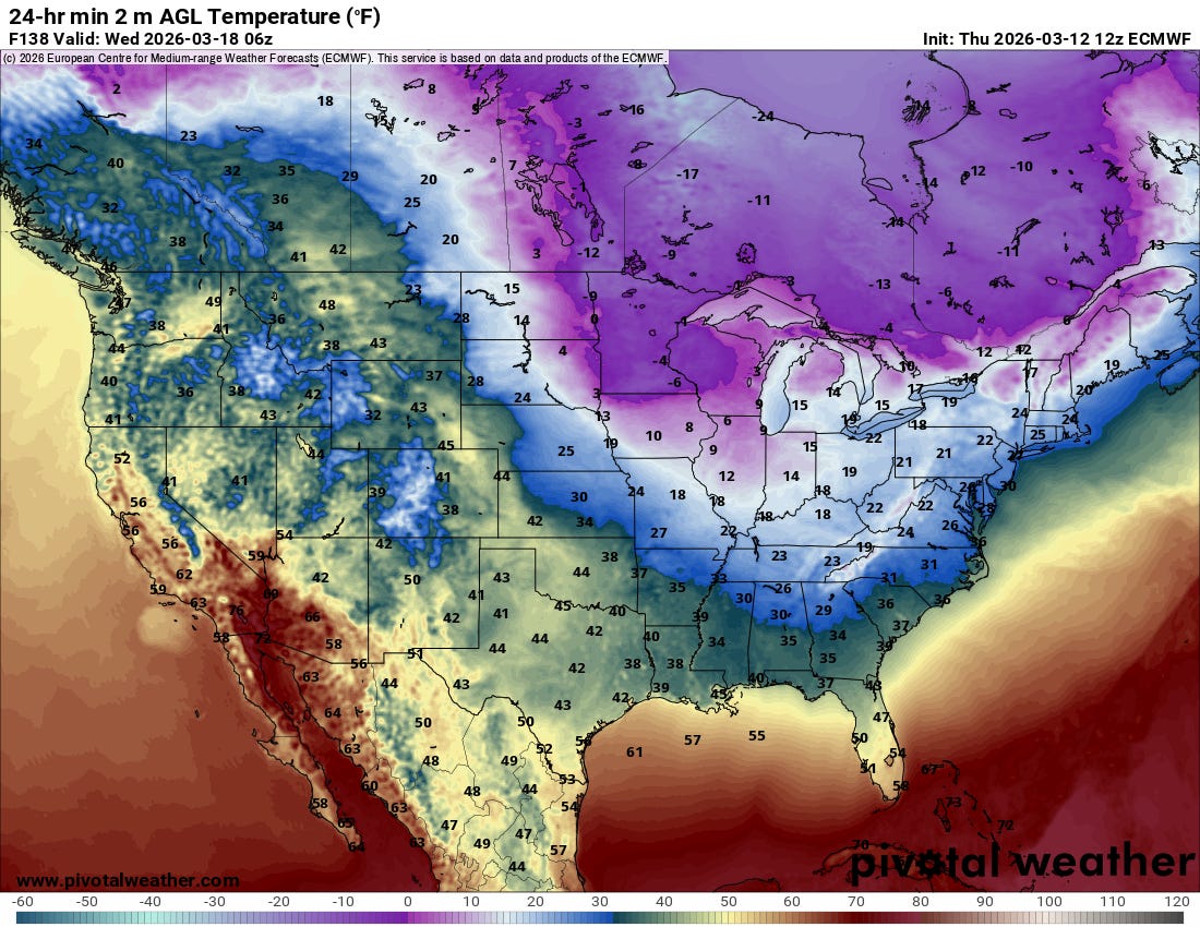
Behind this storm system, another brief shot of Arctic air is expected to overspread the Midwest and East, with a freeze possible well into the Southeast. Not only will this be a rude change from the abnormal warmth of recent days, it could be an issue for some plants given the premature budding brought on by the warm temperatures.

Leave a comment