Also new information about the southern Michigan tornadoes of a week ago
Mar 13, 2026
Happy Friday! Lots of impactful weather to talk about today. However, I will be discussing that in a video later today because I want to focus my newsletter on the tornado events of the last week as there have been some new developments, starting with the Kankakee, IL area tornado Tuesday evening. Teams doing debris removal in Aroma Park, just southeast of Kankakee, on Thursday sadly found the body of a man who had been killed in the tornado but apparently not reported missing. Damage in the Aroma Park area was intense, and while the preliminary rating for the tornado was at least EF3, my understanding from multiple sources is that a NWS Quick Response Team (QRT) is examining the damage in that area with the potential for a higher rating.
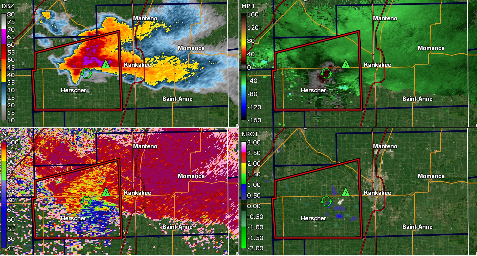
The supercell that produced this intense tornado was as classic of a supercell as you will ever see. It rapidly developed back to the southwest near Pontiac, IL where it produced an initial brief tornado. The supercell “cycled” after that, meaning it went through a period where the low level rotation weakened. After issuing an initial tornado warning for that tornado, the NWS had switched to a severe thunderstorm warning as the supercell went through this cycle. At the time of the radar image above, the storm was completing its cycle and starting to show better low level rotation again.
The severe thunderstorm warning polygon that you can see in the first image was set to expire at 6 pm CDT, and inexplicably no downstream warning was issued ahead of time and the warning was allowed to expire. So for a couple of minutes, there was literally no warning of any type for this clearly high end severe thunderstorm producing — at a minimum — very large hail.
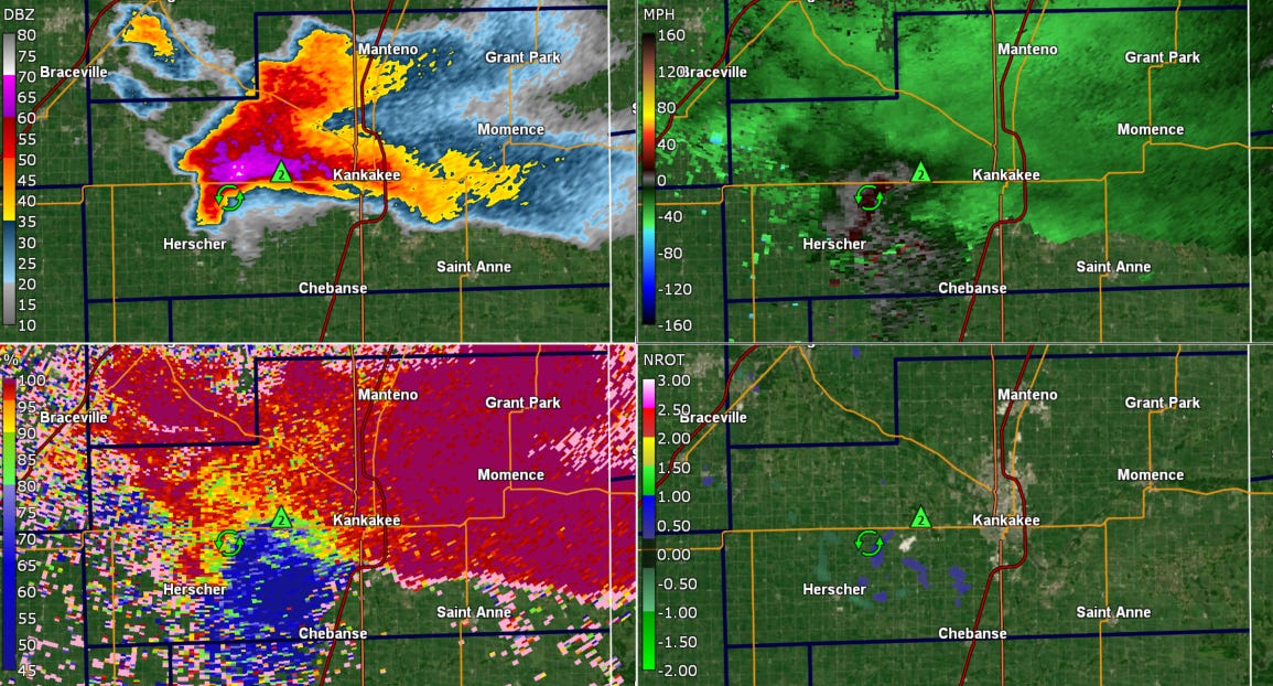
Finally, at 6:02 pm CDT a new severe thunderstorm warning was issued. While this severe was issued with a “destructive” impact tag for 3” diameter hail, I have to be honest that other aspects of this warning confuse me. First, the warning is oriented toward the north and northeast while the storm itself was generally moving east-northeast and had been showing signs of potentially showing what meteorologists call “deviant motion” to the right, a very common occurrence with well developed supercells. The placement of the warning polygon meant that only part of the city of Kankakee was included, and indeed the headline for the destructive impact tag highlighted “NORTHWEST KANKAKEE COUNTY,” not the city of Kankakee which unfortunately was about to get impacted by giant hail.
Also, the warning did not have a “tornado possible” tag which (per NWS directives) indicates to the public and partners that a “severe thunderstorm is suspected to have the potential to produce a tornado but forecaster confidence does not warrant a Tornado Warning at the issuance time of the SVR.” Given the environment — this storm was in the heart of the moderate risk that SPC had issued for significant tornado potential — and the increasing signs of low level rotation, I do not understand how one could not say this storm had tornado potential
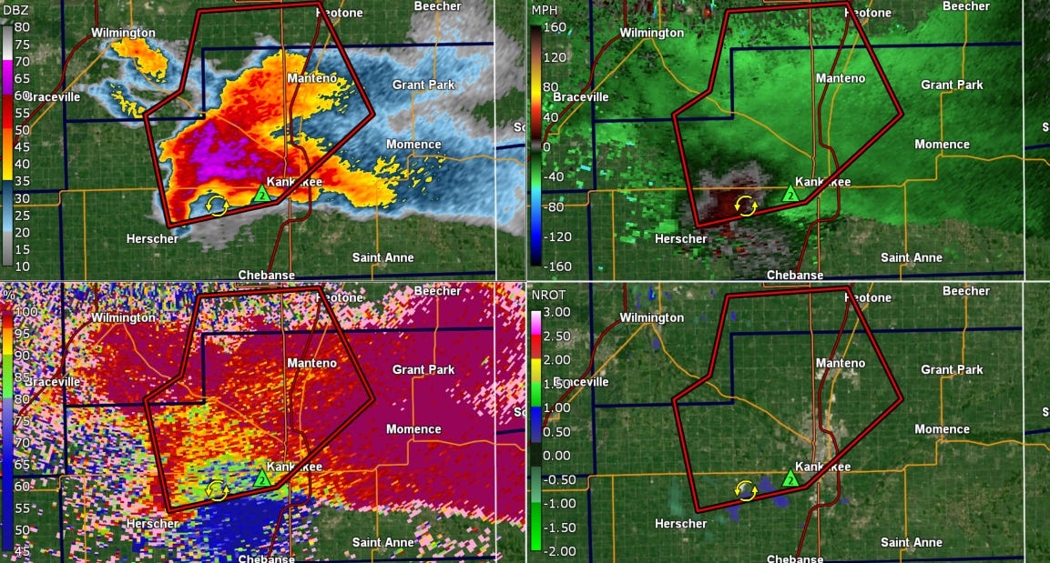
By 6:09 pm CDT, it became apparent that the storm was deviating more to the right, and a new destructive severe thunderstorm warning was issued farther south, including all of the city of Kankakee. However, there was still not a “tornado possible” tag in spite of the continually increasing low level rotation.
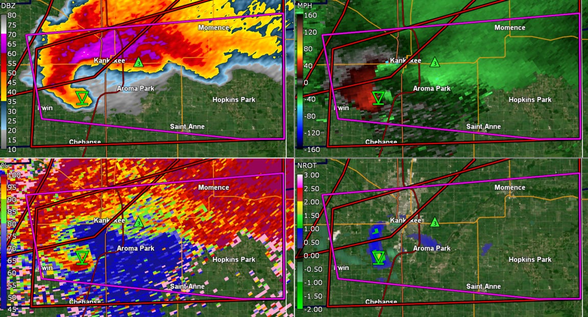
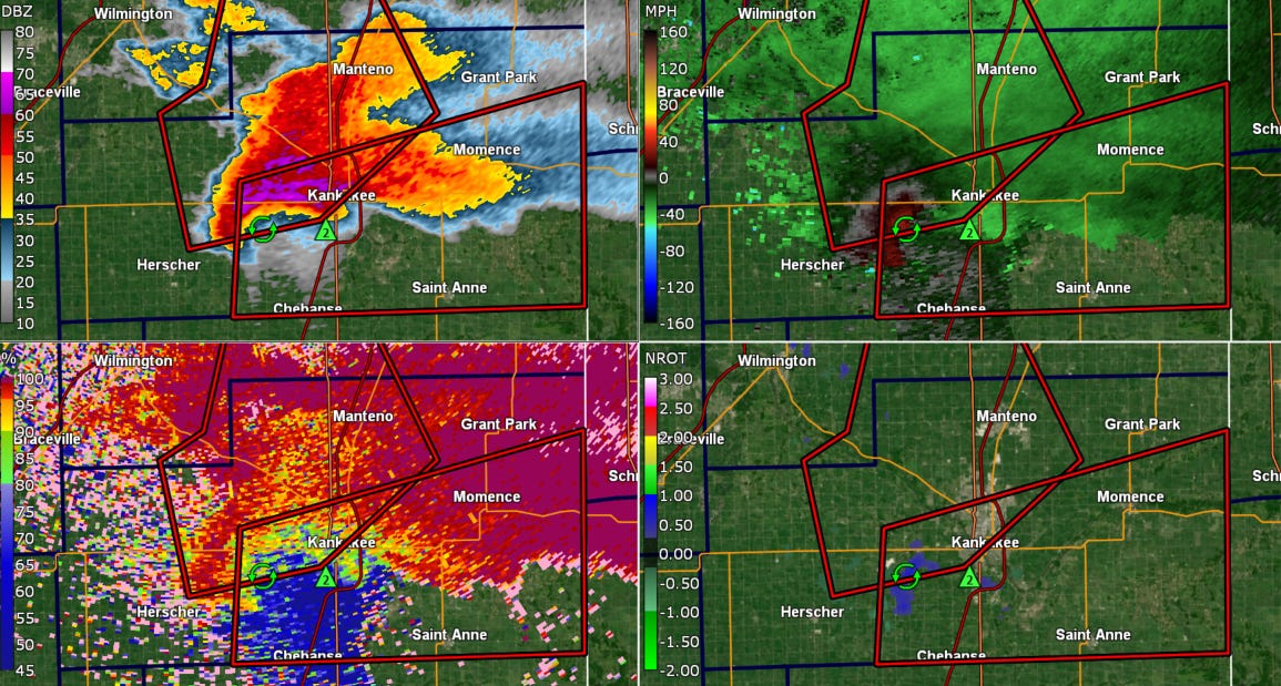
The tornado warning would not be issued until 6:16 pm CDT, by which time there were pretty clear indications on radar that a tornado had either begun or was in the process of developing. Normalized rotation from GR2Analyst at the lowest elevation (lower right in image above) had increased to greater than 1.5, indicative of the potential for a strong tornado — and correlation coefficient data had hints of potential tornadic debris (not the blue area to the northwest of the tornado symbol in the lower left, but rather a smaller, more subtle area under the symbol).
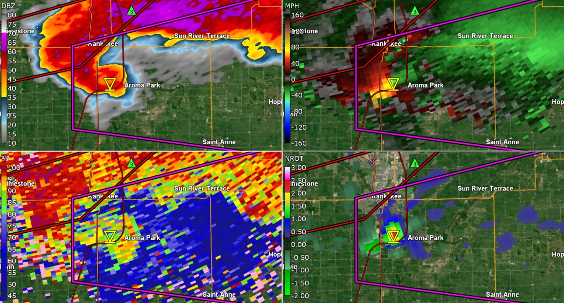
The current NWS preliminary survey for this tornado has the tornado starting at 6:18 pm CT, which may very well be dead-on as I obviously do not have access to the actual damage evidence and detailed spotter reports. Even if that time is correct, though, that means that only 2 minutes of lead time was provided for this tornado which about 10 minutes later would be moving into Aroma Park as a potentially violent wedge tornado.
I have to admit that it makes me somewhat uncomfortable to be publicly talking about what I perceive as shortcomings in NWS warnings — I did the job of both overseeing warning services and actually sitting in the chair and issuing warnings for many years, and I know how difficult the job is and how the “fog of war” can complicate things. However, I also know how vital these warnings services are to our society — they are truly a matter of life and death — and I feel compelled in my current role with Balanced Weather to be forthright in what I am seeing.
A major reason I am going through this event in detail is because I think it reinforces a number of the issues that I brought up in my discussion of the Commerce Inspector General’s investigation of NWS tornado warnings. To summarize again, the report found that the NWS has been meeting their performance goals for false alarm rate (i.e., minimizing the number of tornado warnings where nothing happens) but not meeting their goals for detecting tornadoes or lead time.
As I alluded to in that post, about 15 to 20 years ago the NWS did need to make somewhat of a course correction to try to reduce false alarms, but that effort should have been focused on eliminating “bad” warnings (i.e, tornado warnings that truly were not warranted) or trying to reduce warnings in environments that are only marginally supportive of tornadoes. The environment Tuesday evening in east central Illinois was the exact opposite of a “marginal” tornado environment — it had correctly been identified by the Storm Prediction Center as an environment supportive of potentially long tracked, violent tornadoes.
The NWS goal for lead time for all tornadoes, including weak EF0s and EF1s, is 13 minutes. So in theory, the average lead time goal for strong to violent tornadoes should be even higher. As I said in that earlier post, in spite of what some of my colleagues appear to think, I do not believe that the data supports the idea that the decreasing trends in detection and lead time for NWS tornado warnings over the last 15 years is due to our ability to detect more of the weaker tornadoes. To me, this Kankakee case is an empirical example that shows that we are not being as effective as we could be with even the stronger tornadoes. Only having 2 minutes of lead time for a tornado where the meteorological community was focused in on that particular region for maximum tornado potential — and this exact scenario of an intense supercell moving along the warm front in a high end tornado environment — is very discouraging to me. Those feelings are only exacerbated by the problems with the preceding severe thunderstorm warnings that I discussed, e.g., wrong orientation of polygon, not having tornado possible tags.
The focus of Congressional appropriations the last several years with regard to NOAA and tornadoes has been on the Tornado Warning Improvement and Extension Program (TWIEP), whose stated goal is to provide actionable tornado warnings and guidance to society at increased lead times. Research-to-operations projects like Warn-on-Forecast are working to push lead times out dramatically, which is the goal that NOAA is being directed to pursue by Congress. However, events like this one in Kankakee and last week’s in southern Michigan indicate to me that we not properly leveraging all of the data and science we have right now to provide the public with more actionable lead times, even in clearly high end environments.
Speaking of the southern Michigan tornadoes last Friday, MLive published an article this morning examining again the issue of why there were no watches or warnings issued ahead of the tornado that killed a 12-year old boy near Edwardsburg, MI. The article implies that a main factor in the lack of a tornado warning was that low level radar data was only being received every 5 minutes, and that the tornado developed during that “gap” with no data.
While it is true that the lowest level data was only being gathered every by the Northern Indiana radar every 4 to 5 minutes, that is because the meteorologists at the office were operating the radar in a mode that only gathers data that frequently. The NEXRAD radar has a number of “volume coverage patterns” (VCPs) that it can be operated in to optimize data collection for a number of different meteorological situations. In recent years a number of research-to-operations projects resulting from partnerships between the National Severe Storms Laboratory and the NWS Radar Operations Center have resulted in the implementation of new scanning strategies specifically to help improve monitoring of severe storms for tornado warnings.
These new VCPs and available optional strategies can provide a meteorologist with data from the lowest elevation angle as frequently as every 1.2 minutes. However, the Northern Indiana radar was operating in what is known as “VCP215 with AVSET,” a kind of default scanning strategy for general precipitation, until switching at 2:46 pm to “VCP212 with AVSET,” a more thunderstorm focused strategy. Being in these VCPs is why they were only receiving low level radar data every 4 to 5 minutes in the lead up to the tornado. By 3:19 pm — after the tornado warning was issued — they switched to “VCP212 with SAILS2,” a severe thunderstorm focused scanning strategy that provides more frequent low level data.
Any meteorologist with severe thunderstorm experience will tell you that more — and more frequent — low level radar data is extremely beneficial in issuing timely tornado warnings. This is why these new VCPs were developed — and why they need to be utilized aggressively in severe weather situations. This is also why there is a push among the entire meteorological community to develop new gap-filling radars that would obtain low level data in areas that the current NEXRAD network does not.
Again, I want to emphasize that I am not bringing all of these issues up just to be critical. And of course NOAA and the NWS specifically have had to deal with major staffing cuts and administrative constraints that have made it more difficult to do their jobs and drastically messed with staff morale – we cannot or should not forget that. However, I feel that given the crucial nature of tornado related weather services we also have to be clear-eyed about our work and recognize that some of what we are seeing today are more systemic issues. I feel compelled to continue to share my experience based observations to hopefully bring more awareness to these issues and help the entire weather enterprise continue to improve our critical services.
I will have a video up later this afternoon providing an update on the various potential high impact weather events in the coming week.

Leave a comment