Major and potentially historic blizzard anticipated in upper Midwest and Great Lakes Sunday into Monday, with unprecedented March heat wave building for the West
Mar 14, 2026
I promise to focus today’s newsletter on the very high impact weather that occurred yesterday and is forecast through the next 7 to 10 days — but I have to first share a few thoughts about an article that several people sent to me yesterday. CNN reported that response teams doing search and rescue after recent tornadoes were “flying blind” because FEMA had let a $200K contract for rapid, high resolution mapping of tornado damage paths lapse.
NWS can and does provide emergency management with potential tornado tracks using radar data and tools such as the MRMS rotation tracks product. I am not familiar with the FEMA supported tool in question, but I am assuming based on the description in the article that it is a private sector developed algorithm that uses radar data to quickly and automatically provide high resolution data to emergency officials for immediate use in search and rescue, something obviously NWS cannot typically provide. While the tool is paid for by FEMA, CNN reports that it is freely available to emergency management and response agencies at all levels of government.
From the CNN article:
Over the past week, dozens of tornadoes have been reported from Texas to Michigan, part of a wave of severe storms that have killed at least 11 people. As the storms spread, officials from several states started contacting FEMA, asking why they couldn’t access the tornado tracking data. By early this week, they were reaching out to FEMA’s acting chief, Karen Evans – appointed by Noem and the Trump administration – urging her to get the contract approved, especially with more tornadoes in the forecast. Inside FEMA, leaders pressed Evans and DHS to let them restore the mapping tool, which search-and-rescue teams across the country can access when they need it most.
This wasn’t the first time they had made the request. FEMA staff wrote to DHS back in January, asking officials to renew the contract and ensure the potentially life-saving technology would be readily available, especially heading into the spring, when tornadoes are most common, according to two sources with knowledge of the request. Thousands of FEMA spending requests have made their way to the desks of Evans and Noem, sources and documents show. Many have been slashed; others have sat for months. As of earlier this week, the tornado mapping contract still had not been renewed, the two sources said. “We’ve been told to get out of the way and empower the states, but the reality of what that looks like is not even providing these basic enabling technologies to our state and local partners,” one of the sources said.
This last observation by the FEMA source is to me at the heart of the issues here. The administration continues to say they want to “empower the states” and get the feds out of the way in the emergency management world — but even if that is a desirable outcome (which is debatable), it does not happen by magic. There needs to be a comprehensive plan – and just stopping FEMA from supporting critical activities is not a plan, it is a recipe for disaster.
Furthermore, as I have mentioned multiple times, part of the reason why FEMA plays a critical role in emergency management operations in this country is because many tools and resources do not make sense for individual states or localities to try to maintain. Just about every state may at some point have need for the tornado tracking tool in question — but each state does not have the level of tornado risk or budget for it to be practical for them to develop or pay for such a tool. FEMA contracting for this tool at a national level and providing access to all emergency management and response agencies is much more efficient and cost effective. Stopping FEMA from these sorts of coordinated emergency management activities is in my mind completely nonsensical and counterproductive.
And of course, allowing access to a critical tool such as this to lapse as we are approaching the peak of tornado season without notifying the state and local emergency managers and search/response teams that rely on it is totally unacceptable. As I mentioned yesterday, a body was unexpectedly discovered in the Aroma Park, IL tornado damage on Thursday, nearly 48 hours after the tornado. Whether the delay in discovering this individual had anything to do with teams not having access to this tool is of course speculation — but it is speculation that would not have been needed if the tool were actually available. This situation to me is just another example of the deterioration of our national emergency management infrastructure as FEMA continues to flail without leadership or a strategic plan. It seems to me only a matter of time before more serious issues come to light.
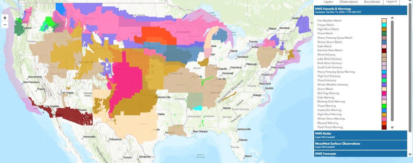
Now, let’s talk about the weather. This is the current continental United States map of NWS warnings, watches and advisories — and it is one of the busiest of these maps that I have seen in a long time. Most parts of the US are under some sort of watch, warning or advisory — and most of those areas of the South and East that look “clear” are under a risk of severe thunderstorms Sunday into Monday that is not shown on this map. This map also does not show Hawai’i, which is dealing with major impacts from a “kona low” weather pattern and a variety of flood, high wind and winter weather watches and warnings are in effect for the state.
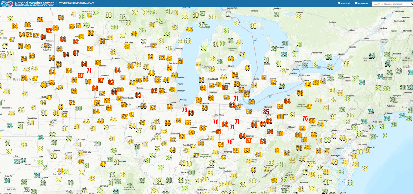
Major wind damage events can be caused by a number of meteorological situations, hurricane and severe thunderstorms perhaps the most damaging. Yesterday much of the Midwest and Great Lakes was impacted by what meteorologists call a “synoptic” or “gradient” wind event, where the winds from an intense extratropical low pressure system produced widespread damaging wind gusts. This was one of the most impressive synoptic wind events I have ever seen in this region, with numerous locations reporting wind gusts over 70 mph as seen above and an incredible peak wind gust of 85 mph at Cleveland-Hopkins Airport.
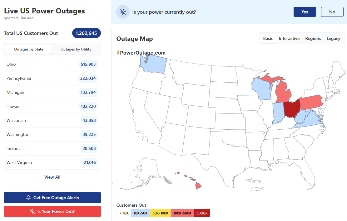
Not surprisingly, this had a huge impact on the power grid, with about 1M customers without power in the region last night — and an additional 100K customers dark in Hawai’i. While some power has been restored, more than 750,000 customers are still without power nationally including 100+K in Hawai’i. American Electric Power Ohio reported that this was the most damaging weather event for their power grid since the June 2012 Derecho.
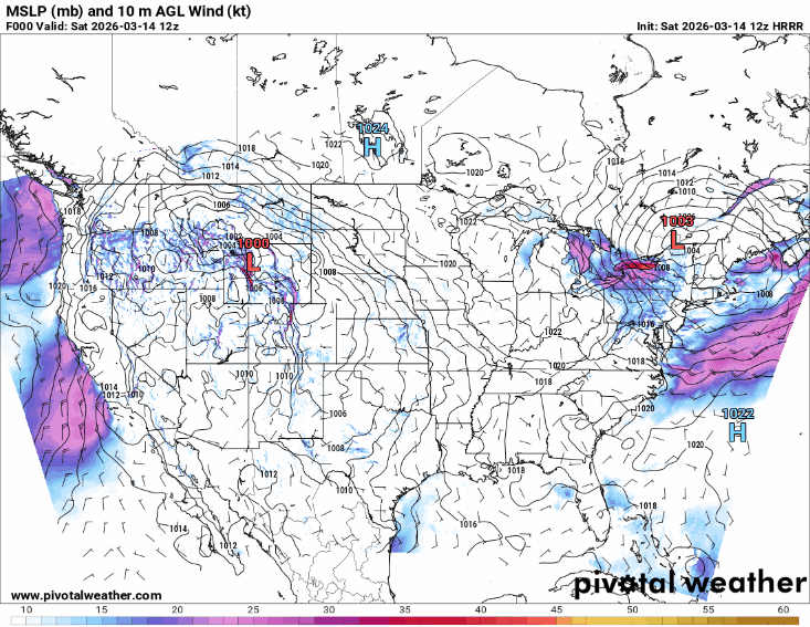
Unfortunately, the active weather is not slowing down anytime soon. An intense upper level weather disturbance diving southeast across the upper Midwest over the next 24 hours will result in the development of a strong area of low pressure over the Central Plains tonight that will further intensify at is moves northeast toward the Lower Great Lakes on Sunday.
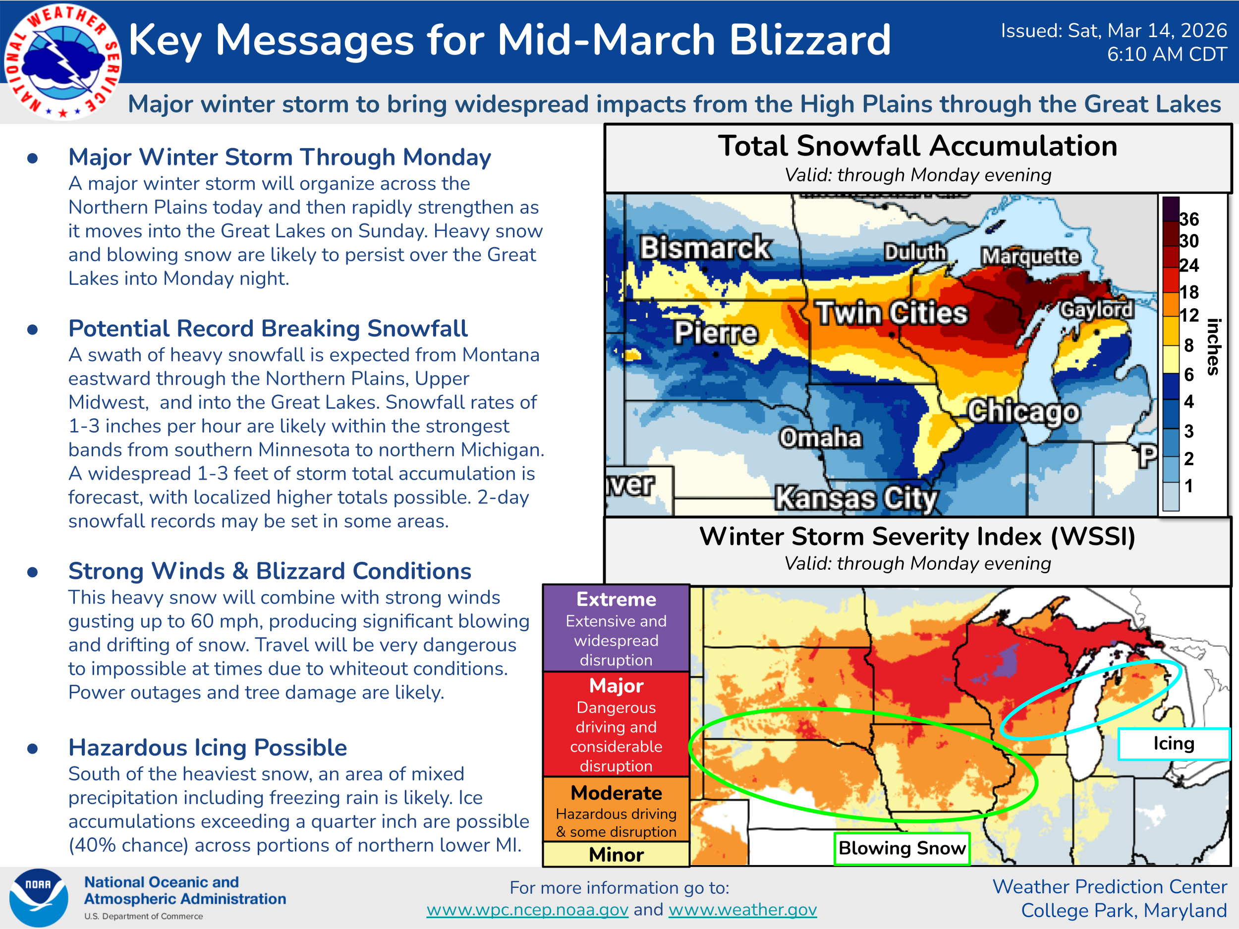
A potentially historic blizzard will result across the upper Midwest, with snowfall totals in excess of a foot expected to be widespread from northeast South Dakota across the Upper Peninsula of Michigan along with widespread wind gusts greater than 50 mph.
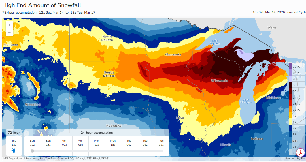
The “reasonable worst case” (1 in 10 chance) snowfall from the NWS Weather Prediction Center shows at least the potential for amounts of 2 to more than 3 feet in these areas, which would set 2-day snowfall records in some locations if they occur.
Significant and widespread impacts from wind are also expected from this storm system. From a “gradient” wind perspective, you can see in the surface map animation above, the highly packed isobars surrounding the intensifying low pressure system, i.e., lots and lots of pressure lines. This shows an intense pressure gradient that will support widespread wind gusts greater than 50 mph across the Midwest and Great Lakes, and high wind warnings and watches are in effect for many areas.
Additionally, it now looks like sufficient low level moisture will come north from the record warm Gulf of Mexico to result in a line of severe thunderstorms along the strong cold front with this low pressure system.
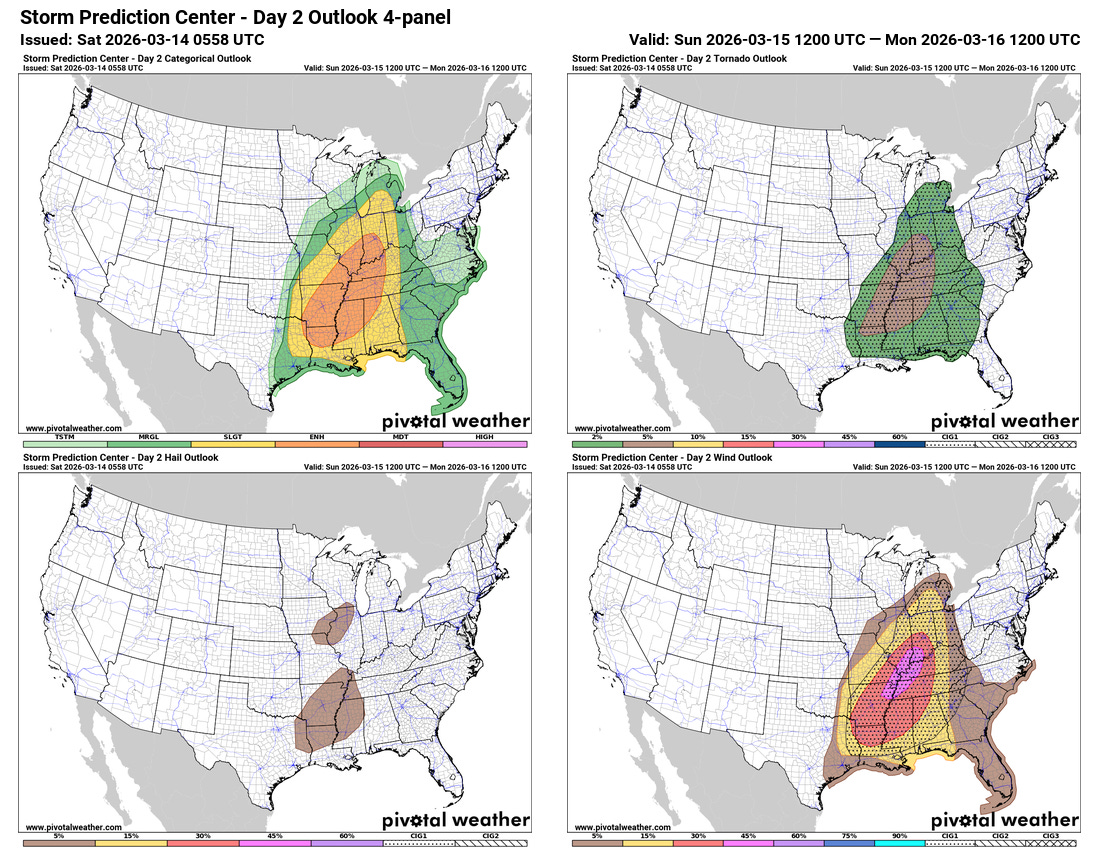
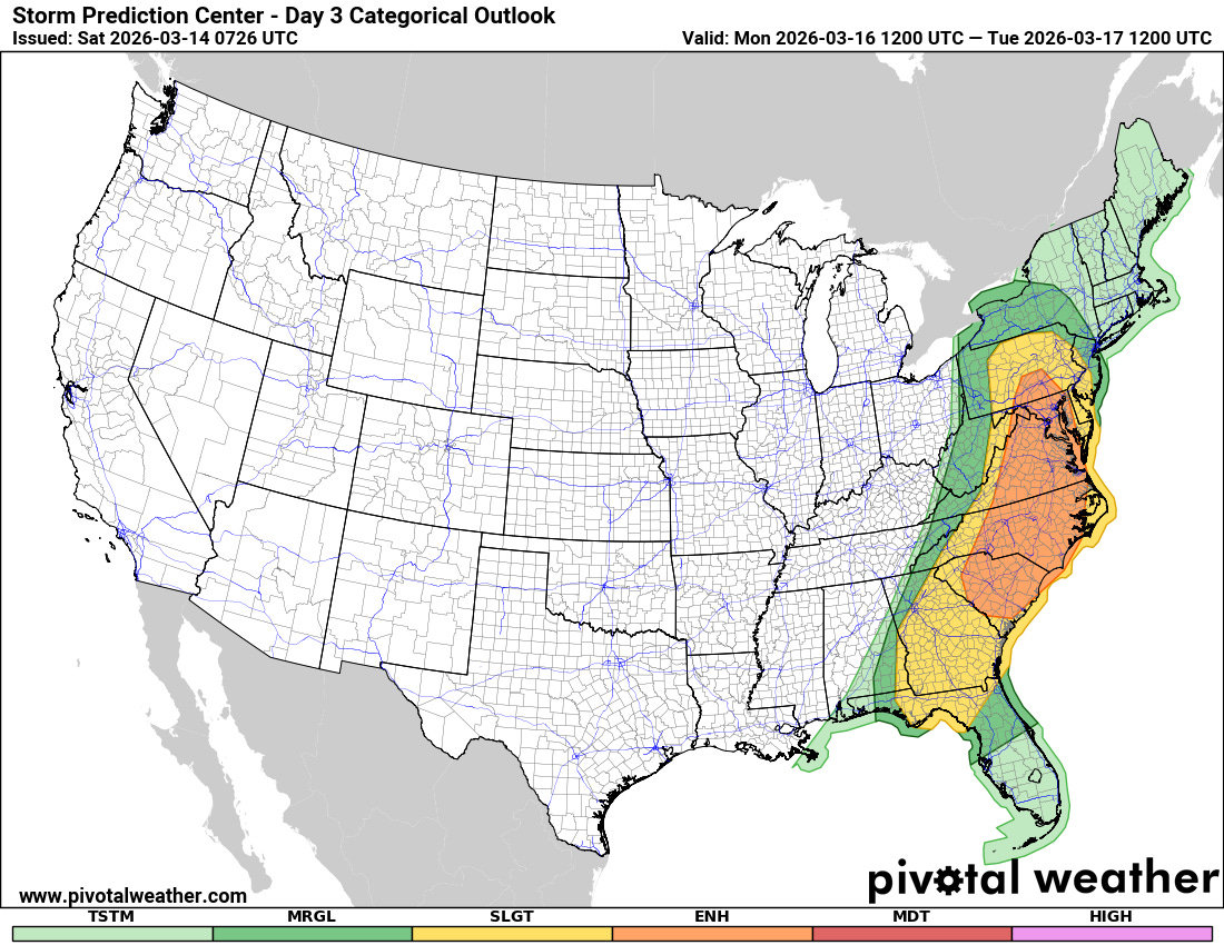
Widespread, and potentially significant, damaging wind gusts along with potentially a few strong tornadoes are expected with this line as it sweeps east Sunday into Monday. The tornado risk would be increased with any discrete supercell storms that can form ahead of the line, which does seem possible particularly over portions of the Gulf Coast and Mid-Atlantic regions where slightly more moist and unstable air will be present.
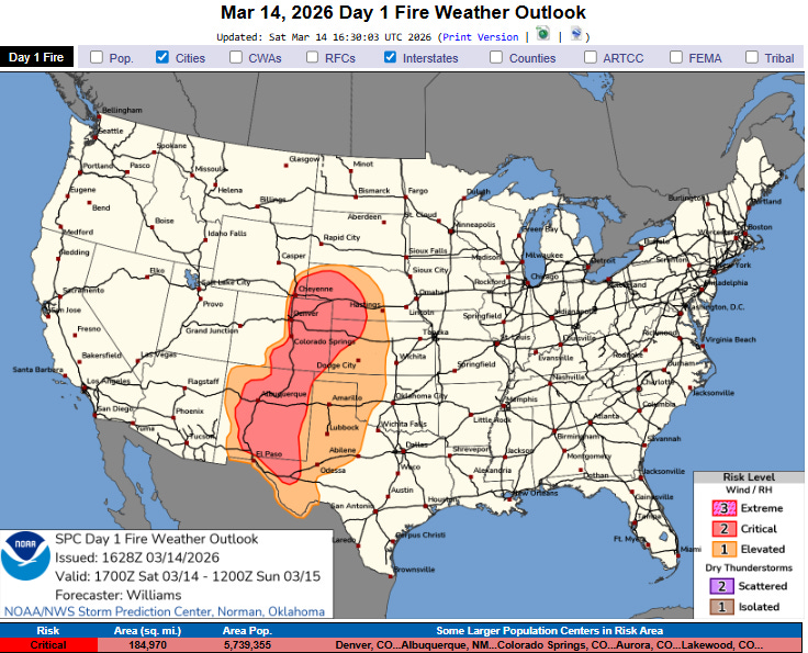
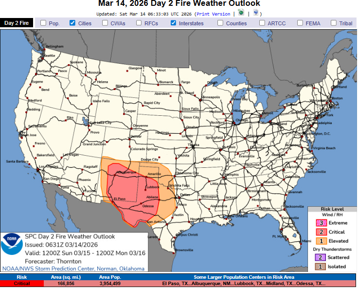
Critical wildfire danger will also be a serious concern the next couple of days across portions of the Plains and Southern Rockies with strong winds, dry air and ongoing drought conditions.
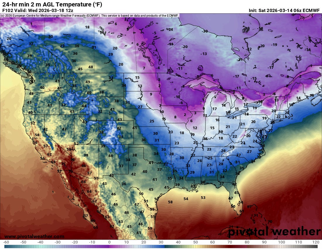
Sharply colder Arctic air will surge south in the wake of the strong cold front, with a freeze expected well south toward the central and eastern Gulf Coast for Tuesday and Wednesday mornings.
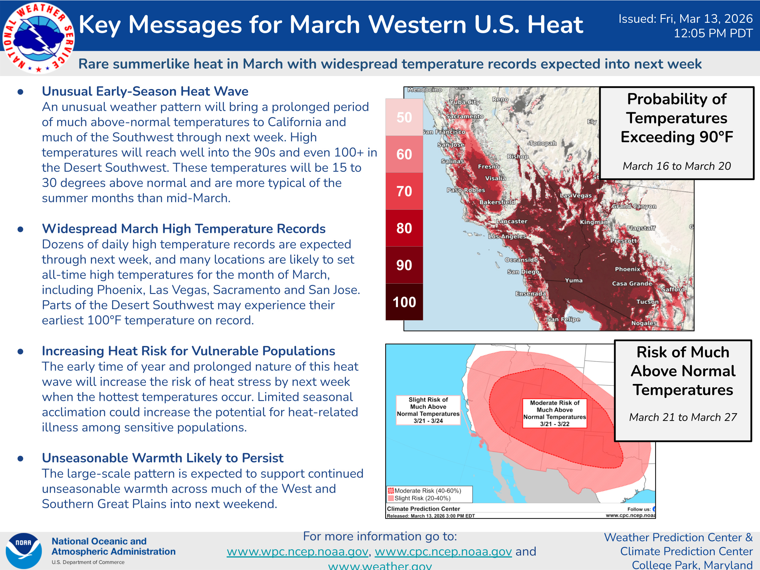
This will be in stark contrast to what is a developing historic March heat wave for much of the western United States. Numerous locations by the middle to latter part of next week will be experiencing record high temperatures for the month of March by several degrees and on multiple days — and some locations will likely reach temperatures not seen historically before well into April. The heat will be extreme enough to result in highly unusual heat risk for so early in the season for areas from the desert Southwest into southern California. I will have a lot more to say about this incredible weather event in the coming days.

Leave a comment