Not sure what else to say: record shattering rainfall in HI, historic blizzard in Great Lakes, significant severe weather outbreak for eastern half of country, and unprecedented March heat in the West
Mar 15, 2026
My good friend Barry sent me a text message this morning asking if I was going to write about Hawai’i today: “the storms there are crazy.” I replied: “Insane storms in HI, insane blizzard in MI/WI, insane severe weather in the East, insane heat wave in the West,” and he said “it’s like a disaster movie.” After thinking on that a minute, I decided that he is right — and that today really deserved just headlining things with the insanity that our weather currently is. Because even as someone who has been an atmospheric scientist watching the weather every day for almost 40 years, this busyness — and the extremes that are accompanying the busyness — is truly rather insane. March Madness indeed.
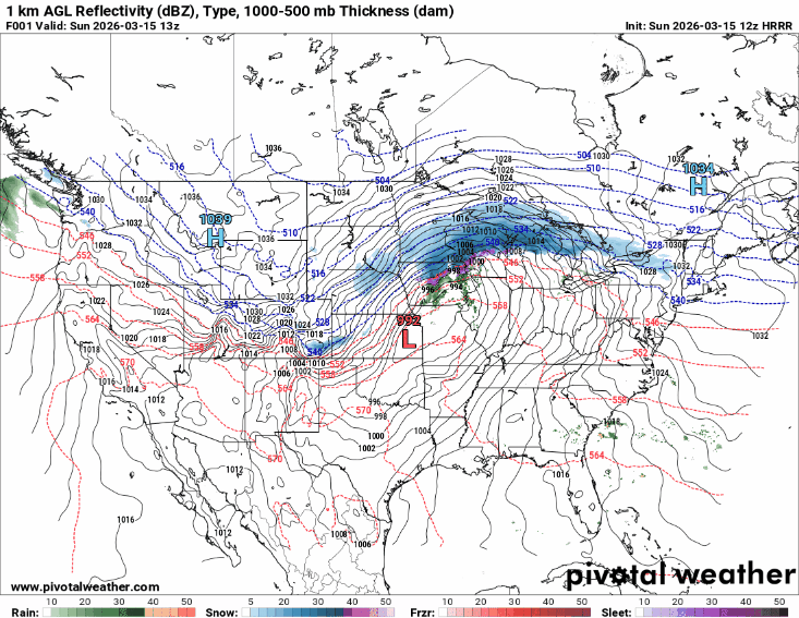
Let’s start off with looking at the big picture over the country the next couple of days with an animation of the surface weather map, i.e., surface pressure with forecast radar/precipitation. The situation is of course dominated by the strong low pressure system over the center of the country this morning, which is forecast to further significant intensify it moves toward and across the Great Lakes the next 24 to 36 hours. A potent late season cold front extending south from the low will sweep east toward and off the East Coast, accompanied by a band of strong to severe thunderstorms.
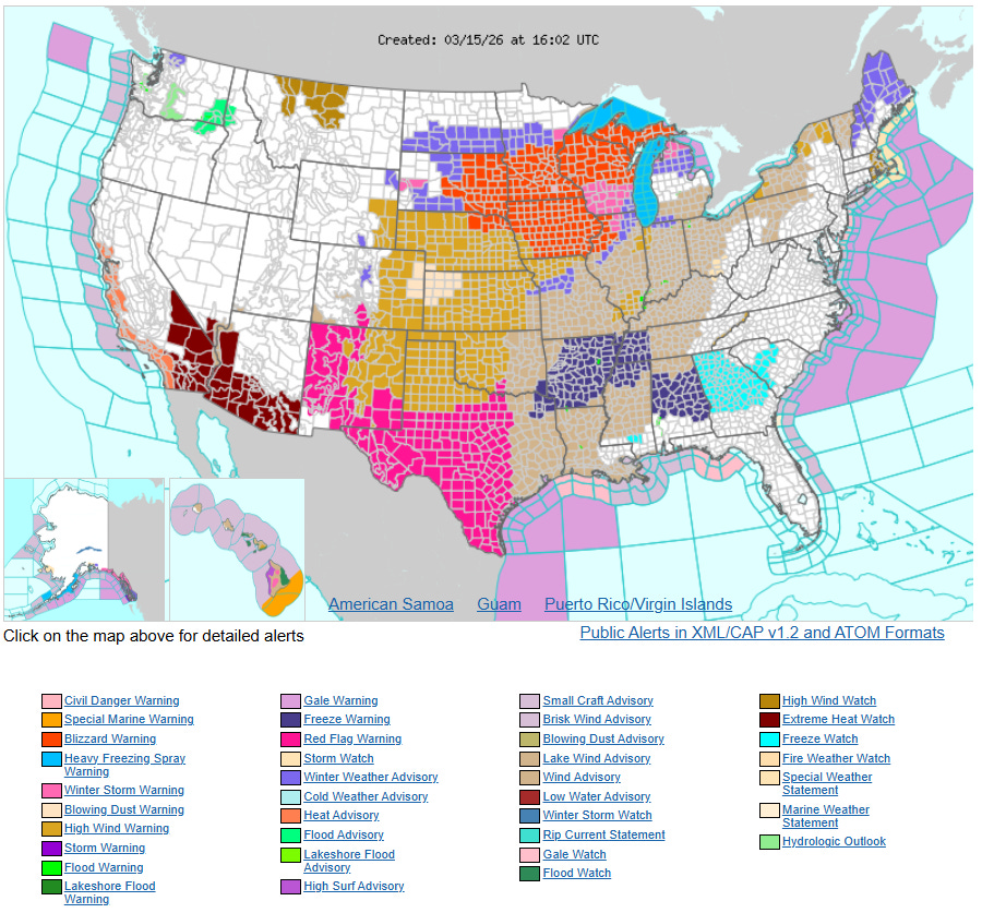
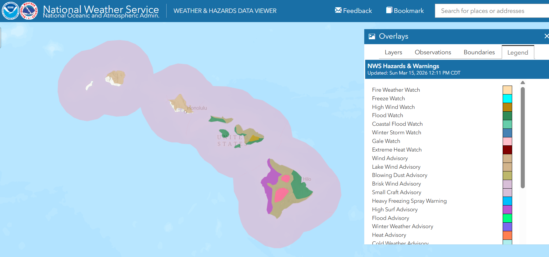
The colorful midday NWS watch/warning/advisory map gives a good high level overview of the anticipated major impacts from this storm system. Blizzard warnings are in effect for much of the upper Midwest and northern Great Lakes, where wind gusts greater than 50 mph and heavy snowfall will result in difficult to impossible travel today into tonight. High wind warnings and advisories are in effect for much of the country east of the Rockies as the strong and intensifying pressure gradient around the low and a polar high pressure system building in behind the system will result in widespread gusty winds greater than 50 mph, causing travel and power issues. These strong winds will combine with dry low level air and ongoing drought conditions to bring dangerous fire weather conditions to the Southern Plains where Red Flag Warnings are in effect. Freeze watches and warnings are in effect for much of the Southeast as cold air surging south in the wake of the cold front will bring freezing conditions to areas that have seen well above normal temperatures much of March.
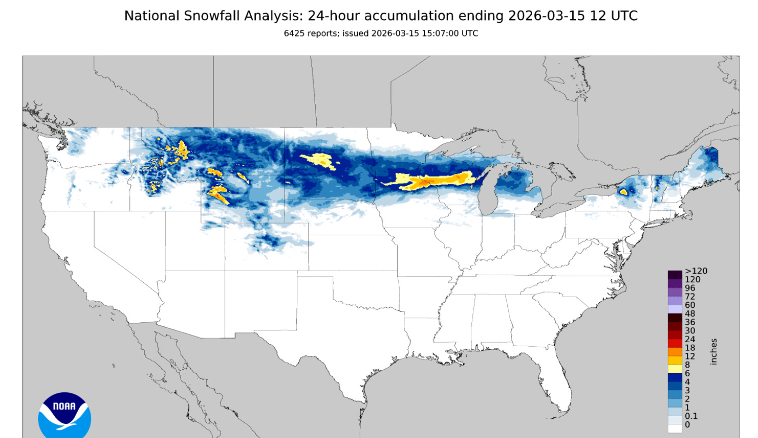
The blizzard is in full swing across the upper Midwest and Great Lakes, as a band of 6 to 12” of snow had already fallen as of 7 am CT this morning. Winds have been increasing across areas of the Dakotas, Minnesota and Iowa — and will be increasing dramatically farther east as the low pressure system continues to intensify and move east.
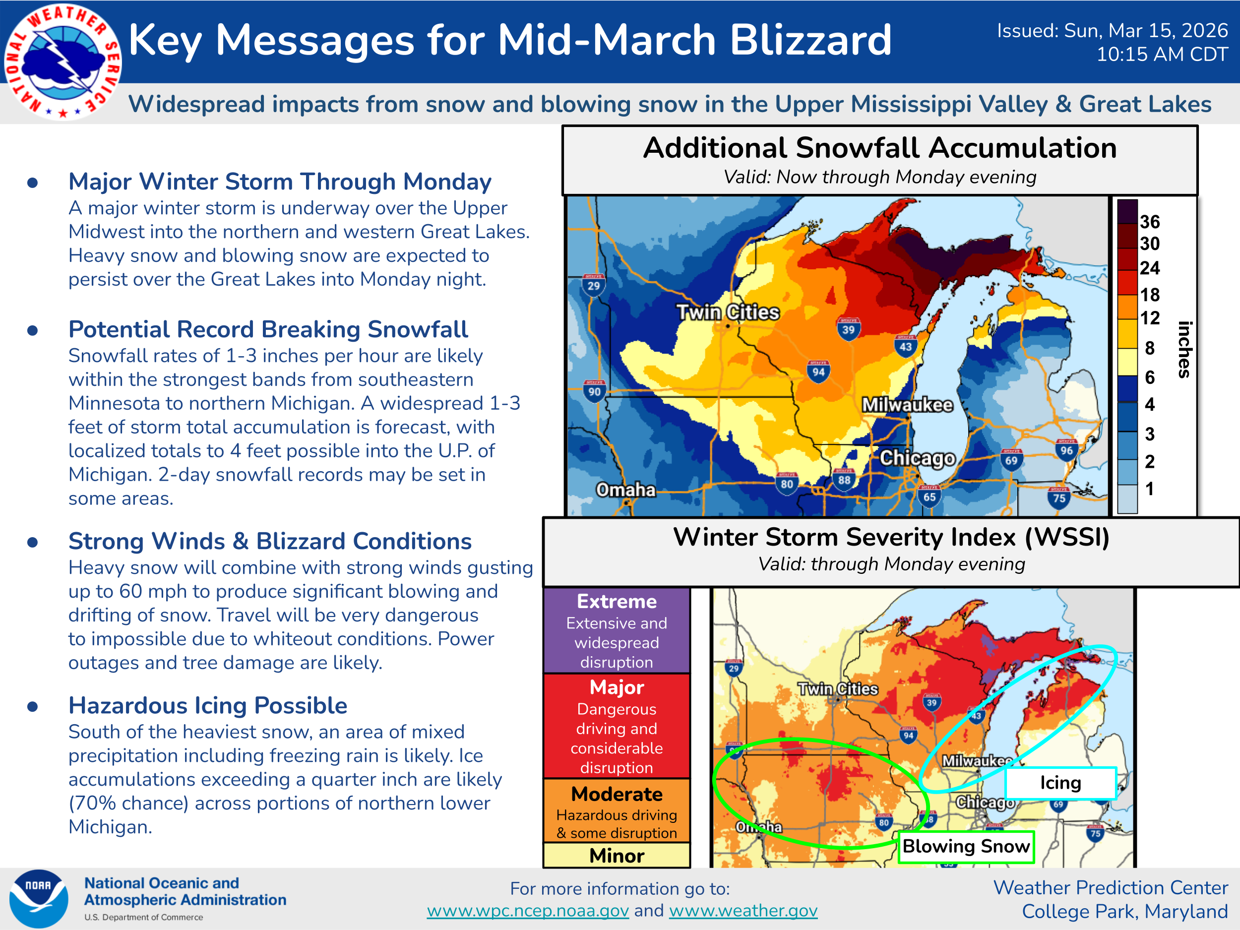
Additional snowfall beyond 7 am CT of more than a foot will be widespread across much of Wisconsin and the upper Peninsula of Michigan. Moisture off Lake Superior will help substantially enhance snowfall totals for the U.P., with snowfall totals of up 4 feet anticipated. As noted in the Weather Prediction Center key messages above, 2-day snowfall records may be set in some areas impacted by this blizzard. Mixed precipitation could cause issues with icing including southeast Wisconsin and the northern Lower Peninsula.
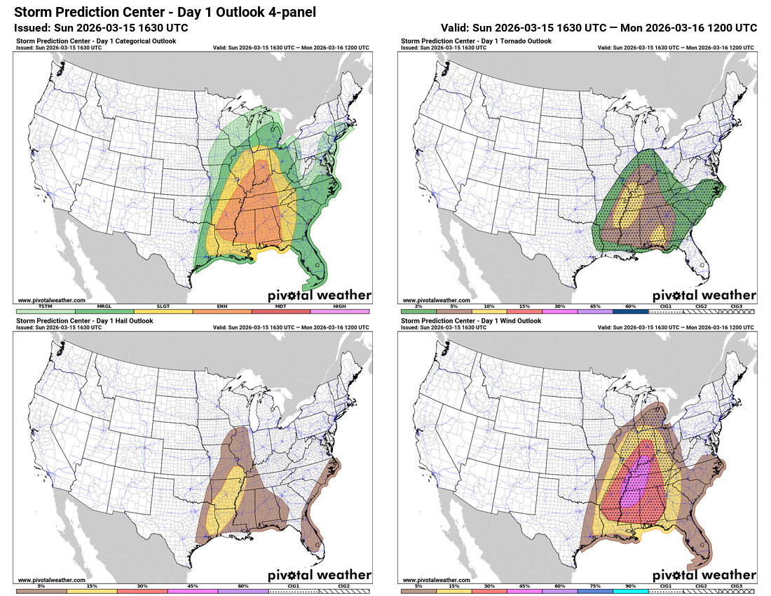
Meanwhile, strong atmospheric dynamics and upper level winds will combine with sufficient moisture streaming north off the record warm Gulf of Mexico to result in a an intensifying line (quasi-linear convective system or QLCS) of severe thunderstorms along the cold front this afternoon and into tonight. This severe storms is expected to cause widespread damaging winds with numerous winds gusts of 60 to 80 mph expected as the line moves east.
Tornadoes will also be possible within the QLCS as it sweeps east with a few strong tornadoes anticipated. A few supercells could develop ahead of the line, particularly from the Ohio River south, and the tornado risk would be enhanced with any of these storms. After midnight tonight, a surge of moisture and unstable air coming north off the Gulf could also lead to an increased risk of tornadic supercell storms across parts of central and eastern Gulf Coast region, where the Storm Prediction Center has an area of greater tornado probabilities outlooked.
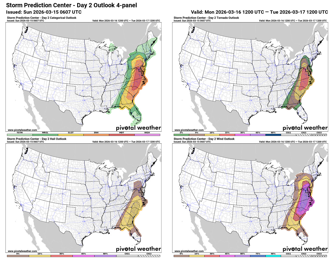
As the cold front shifts east on Monday, the severe weather outbreak will do the same. An unusual moderate (level 4 of 5) risk of severe weather is in effect for portions of the Mid-Atlantic states as the squall line along the front is expected to continue to produce widespread significant damaging winds. Low level moisture will actually be more extensive across this region Monday, which is expected to enhance the tornado risk as well, both with the QLCS and potentially discrete supercell storms developing ahead of the front, particularly across parts of North Carolina and Virginia.
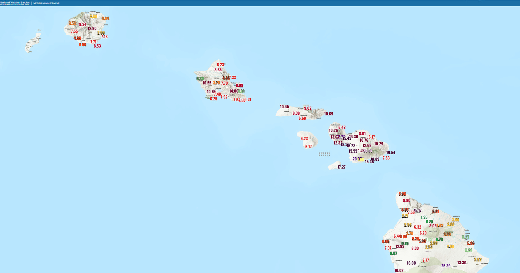
With everything going on the continental US, we cannot forget what has been happening with incredibly active weather in Hawai’i. The above map shows rainfall totals across the islands the last 72 hours as waves of strong thunderstorms have moved across the region as a strong low pressure system continues to slow pass north of the state. This “kona low” pattern is causing widespread heavy rainfall and flooding across the entire state, even in leeward portions of the islands that are typically much drier during normal trade wind patterns. Flash flooding has been a major issue across the island chain, and high winds have resulted in extensive power outages. Currently about 50,000 customers are without power, and totals have exceeded 100K customers at times during the last few days.
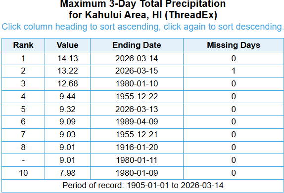
Kahului, the main long term climate site on Maui, had a 3-day rainfall total through midnight this morning of 14.13”, easily setting the record 3-day total. In fact, the two day total of 13.22” broke the record, and given anticipated heavy rainfall today into tonight, it seems very likely the record will be set again.
The focus for precipitation impacts over the next 48 hours should shift toward the eastern part of Hawai’i.
The historic March heat wave for the West is still anticipated as forecast this week as discussed in the WPC key messages above. More to come on this as the week goes on. I will be traveling this afternoon so updates may be infrequent — but should have more this evening and into Monday.

Leave a comment