And marking one year of Balanced Weather
Mar 16, 2026
Good Monday morning! Before I get into an update on where things stand as far as the ongoing blizzard and severe weather impacting the nation, I wanted to note that yesterday marked the one year anniversary of this Balanced Weather Substack — which I started right after taking (slightly) early retirement from a 35 year career in NOAA — and thank all of you who have subscribed to and/or followed me.
I had been kind of hoping for a while to start some sort of a weather related blog as a retirement gig — but did not in my wildest dreams expect that I would spend so much time writing about government science and emergency management agencies trying to stay functional under the duress of attacks on their staffing, budget and administration. Hopefully, I have managed to provide useful insight into what is happening, and helped people understand the often arcane and confusing federal science bureaucracy.
Of course, our actual weather and climate and how we can build a more resilient society is what I would love to most focus on, and hopefully the next year will provide more opportunity for that. Regardless, I intend to continue to provide “balanced” coverage and insight on all of it going forward.
While I of course thank all of the Balanced Weather subscribers, I particularly want to thank those of you who have financially supported this work through becoming founding or paid subscribers. This Substack and everything that has gone with it (lots of media interviews, my own research for articles, etc.) is a passion project for me as someone who deeply believes in the importance of atmospheric science and emergency management. However, it does take a lot of effort and it has tangible costs associated with it (data and news site subscriptions, software and web server costs) so the financial support is deeply appreciated.
As a reminder, a main benefit that paid subscribers receive as thanks for their support is real-time access to Balanced Weather chat and video. Substack has made some improvements over the last several months to these live video and chat functions. My intent is to make more and (hopefully) better use of these capabilities going forward to provide real-time thoughts and coverage regarding ongoing weather, particularly during severe weather and tropical cyclones. So if you have considered becoming a paid subscriber, now is a great time as we get into the busy spring severe weather season and 2026 hurricane season is (amazingly) only weeks away. The link to subscribe is always at the bottom of my articles and posts.
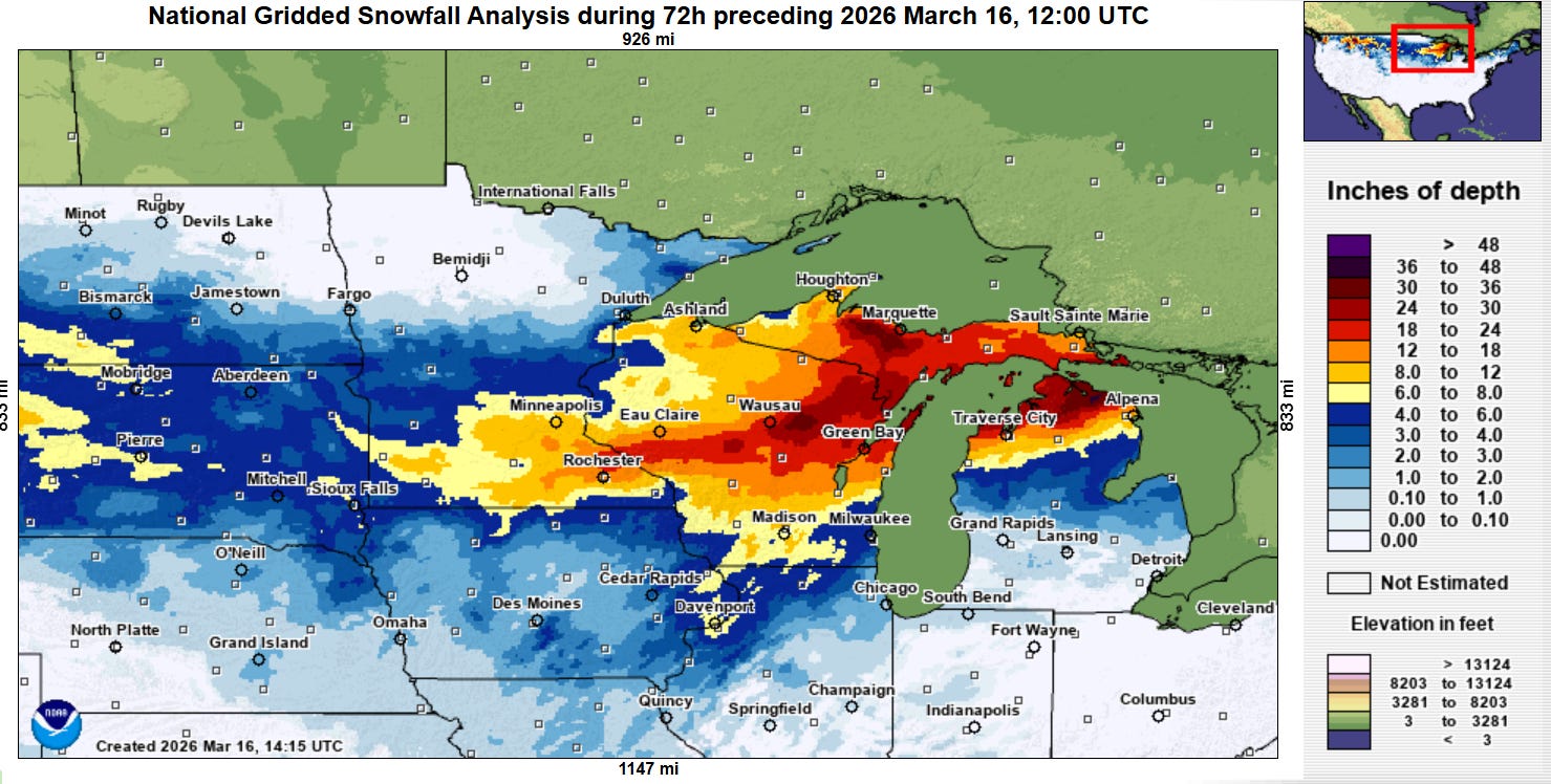
So now let’s turn to the reason why everyone (myself included) is here – the weather. Heavy snow continued overnight across parts of the upper Midwest with the intense low pressure system over the lower Great Lakes. Snowfall totals have now reached 30” at several locations across northeast Wisconsin and parts of northern Michigan.
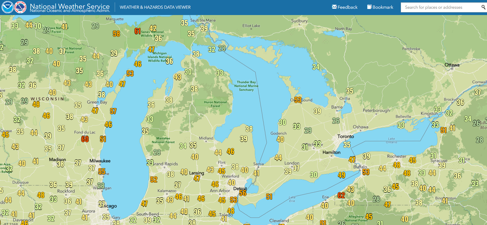
Blizzard conditions with strong winds (max wind gusts since midnight shown above) and poor visibilities also continued.
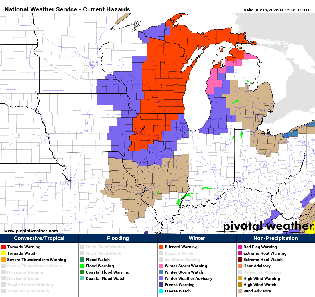
Moderate to heavy snow will continue across the region today, and blizzard warnings remain in effect from northwest Illinois and extreme eastern Iowa across northern Michigan. Strong winds will also continue in surrounding areas due to the intense low pressure center slowly moving east-northeast into Ontario.
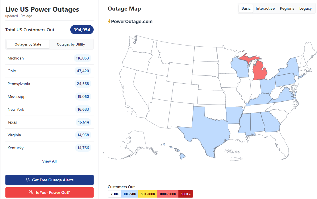
About 200,000 customers are without power in the Great Lakes region per PowerOutage.us, with more than 100K in Michigan.

Meanwhile, many parts of the Ohio Valley and South also have significant power outages due to the severe squall line that passed across this region yesterday afternoon into this morning. More than 600 reports of severe weather have been received by the Storm Prediction Center, including more than 500 wind damage reports. While only a couple of tornadoes are shown on this map, there were a number of tornado warned circulations and supercells embedded in this line of severe storms, and undoubtedly a number of tornadoes will be confirmed once damage surveys take place.
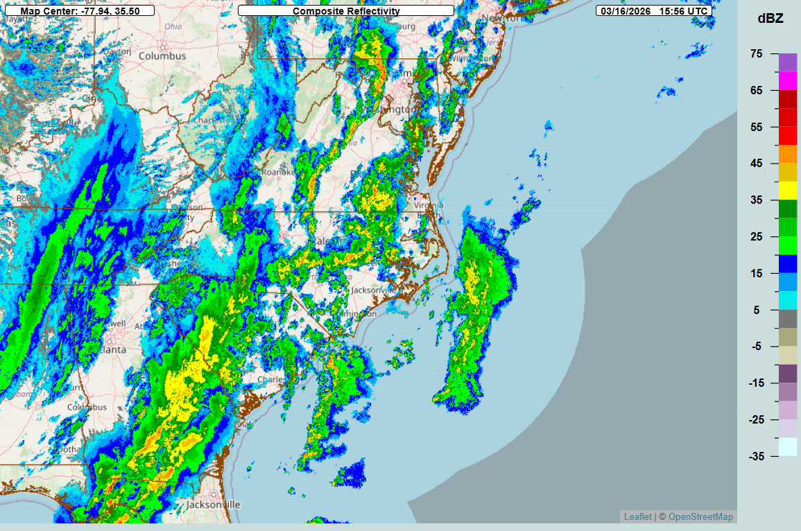
Today’s severe weather forecast for the eastern US is rather complicated and messy. While there are a lot of favorable atmospheric parameters for higher end severe storms in this region today, there are also complicating factors including numerous bands of showers and storms that will reduce daytime heating (which helps make the atmosphere more unstable) and could keep any one particular band of storms become more intense.

All of this means that while the risk for higher end severe storms definitely exists today across the region and tornado watches are in effect from New Jersey and Pennsylvania to the eastern Gulf Coast, pinning down the details of when and where the greatest risks for severe weather will be this afternoon and evening is very challenging. Everyone in the tornado watch areas needs to be paying close attention to the weather today and be ready to take shelter if warnings are issued.
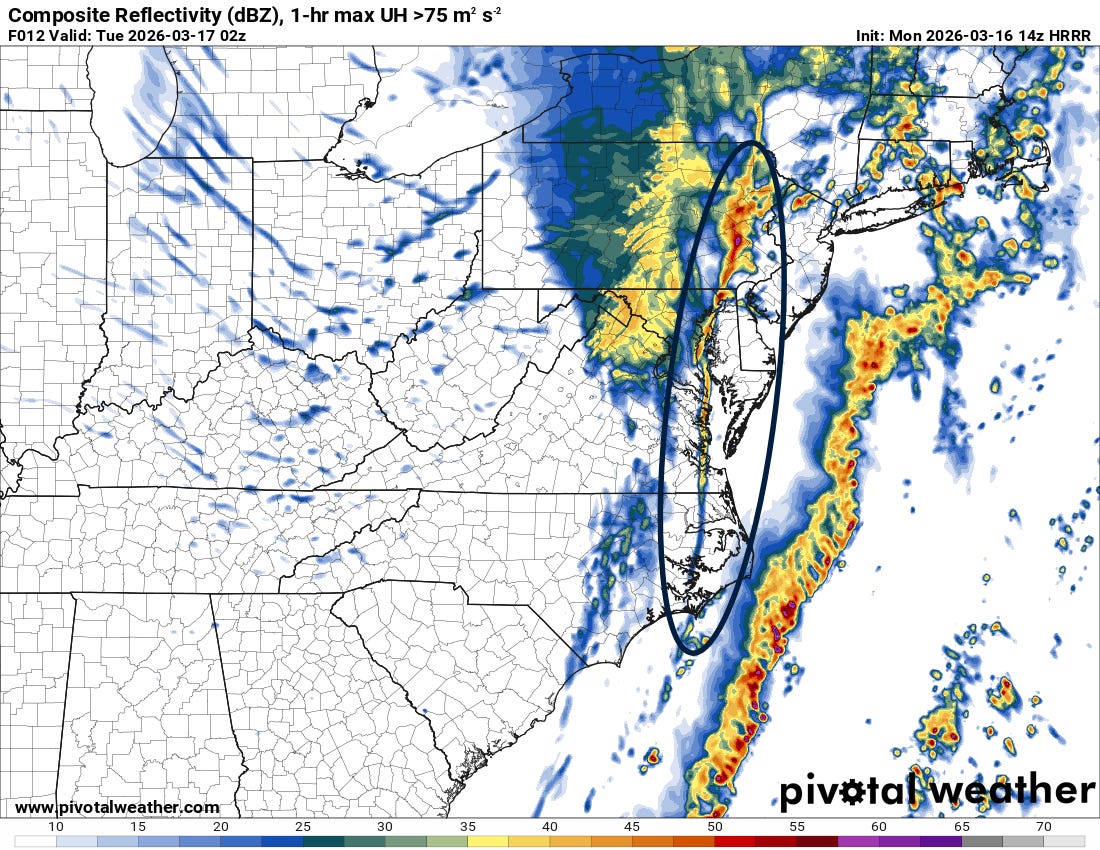
Eventually, a strong forced line of showers and storms should evolve right along the cold front this evening (forecast position for 9 pm ET tonight from latest High Resolution Rapid Refresh model above). This line seems likely to produce strong winds and possibly a few tornadoes as it sweeps across the Mid-Atlantic
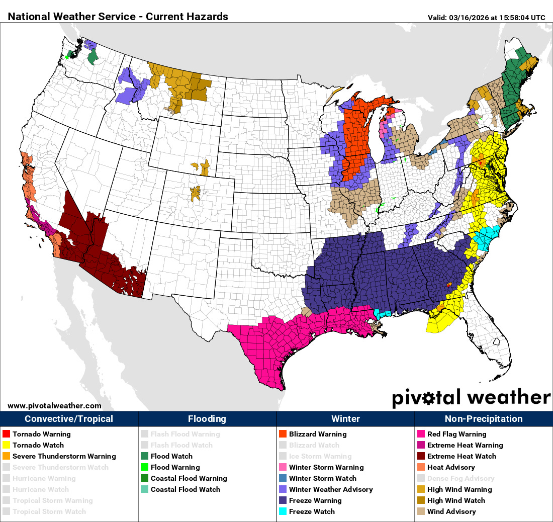
Much colder air will continue to surge in behind the cold front as it presses east, resulting in at least some snow for many areas in the East in the wake of this system. A significant freeze is anticipated the next couple of mornings all the way to parts of the Gulf Coast. Strong northerly winds and very dry air will also result in critical fire danger for parts of the Gulf Coast, and red flag warnings are in effect today.
You can see in the NWS advisory map above that numerous extreme heat watches and warnings are in effect for the Southwest. This is part of an ongoing heatwave that will become a historic and unprecedented March heat event as this week goes on. I will have much more to say about this event in coming days, but in the meantime I want to encourage you to read this excellent article (gift link) by San Francisco Chronicle meteorologist Anthony Edwards which provides tremendous background and context on this incredible event we will witness this week.
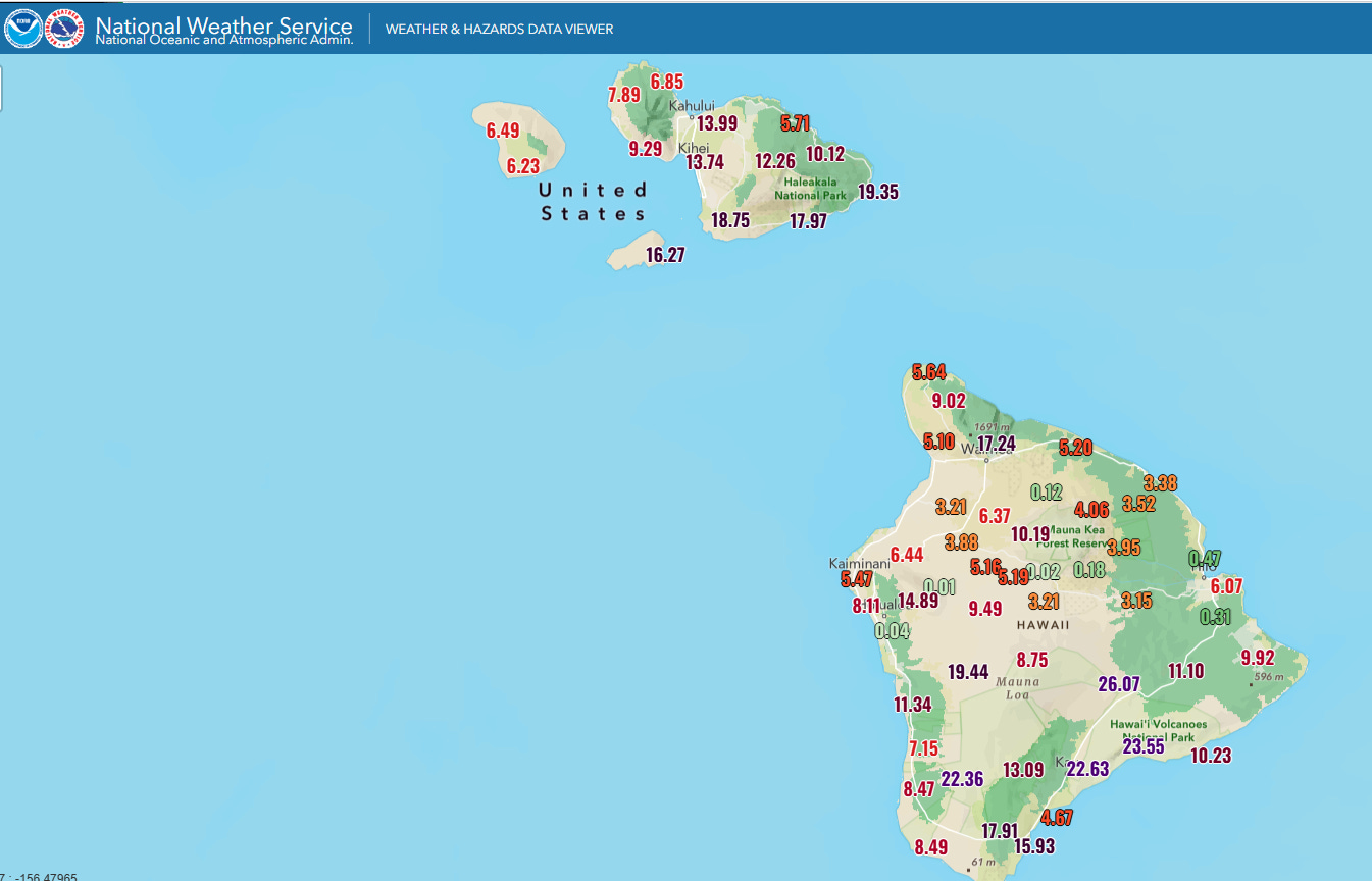
Hawai’i is finally starting to see conditions improve after days of high winds, severe storms, massive rainfall and flash flooding. Maui and Hawai’i had the most impactful rainfall the last few days, and these 3-day rainfall totals shown above do not encompass the entire event, as heavy rain fell on the prior couple of days during which the western islands including Oahu had significant impacts. This story from Hawaii News Now summarizes the 5-day rainfall totals, including the max of 44.37” on Maui.

Leave a comment