In Hawai’i, another kona low is causing “catastrophic” flooding in northern O’ahu
Mar 20, 2026
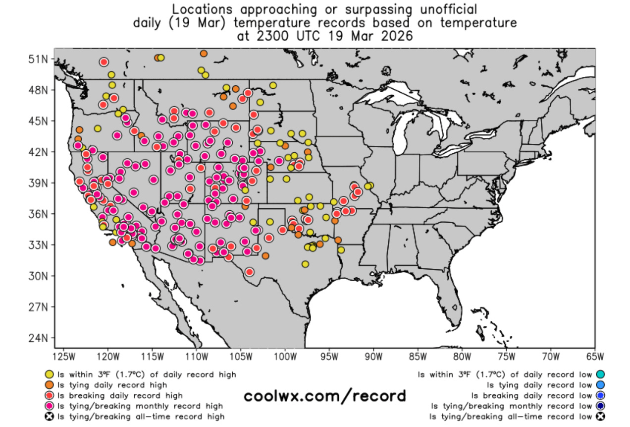
Thursday saw the unprecedented March heatwave over the western United States reach yet another level, as dozens of sites reached all-time monthly record highs (purple dots above) from California northeast to Montana and south to the southern Rockies and High Plains. The NWS Weather Prediction Center reported that the highest temperature recorded Thursday was 110F near Martinez Lake, AZ, which if verified would be the all-time record hottest temperature for the month of March in the United States.
A selection of some of the more impressive records reached yesterday:
- Flagstaff hit 84F, breaking their March record (set Wednesday) by 8 degrees, and reaching that temperature 6 weeks earlier than ever on record. It was the third day in a row with a record monthly high, and before this streak began, the high temperature on Thursday would have broken the monthly record by an astounding 11 degrees. The high of 84F broke the April record high by an incredible 4 degrees. Records at Flagstaff go back to 1898.
- Phoenix hit 105F, not only breaking the record March high (set Wednesday) by 3 degrees, it broke the record for earliest 105F by more than a month (prior record April 20).
- With a high of 95F, Las Vegas set a monthly record for the second consecutive day, and had its first 95 degree day about two weeks earlier than ever before (prior record April 2).
- Albuquerque set a new record monthly high by 3 degrees when it reached 88F on Thursday, reaching that reading nearly a month earlier than ever before (April 10).
- Salt Lake City set a new monthly record with 81F, and had its earliest 80 degree day by nearly two weeks (prior record March 31).
The record map above is truly insane to me for the number and coverage of monthly record highs — and not to sound like a broken record, to be seeing this more than 10 days before the end of the month when most March record maximum temperatures are set is absolutely ridiculous.
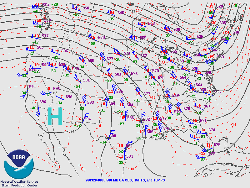
As I have discussed in earlier posts, the primary weather feature driving this historic heat wave is a historically strong high pressure center in middle and upper levels of the atmosphere encompassing the Southwest. This 500 millibar weather chart above shows the weather pattern at about 18,000 ft AGL. The solid lines are contours of height, similar to isobars (pressure lines) on a surface weather map. I have marked the location of the center of the high over southern Arizona.
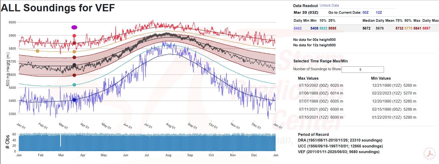
At a very basic level, the stronger the high pressure center aloft, the hotter the temperatures typically are at the surface. The strength of the current high pressure center as shown by the heights observed at 500 millibars is truly off the chart. The Storm Prediction Center maintains a database that show how each day’s upper air observations compare to the historic record — and you can see that last night’s 500 millibar height observation at Las Vegas (purple ellipse I have added on the chart above) is not only a record for the day and month, it is the highest observed value for any day before the end of May.
While today is forecast to be the absolute peak of this record heat as far as the number of records and expanse of abnormal heat, the general weather pattern of an unusually strong upper level high pressure center anchored over the Southwest is not expected to change for at least the next 10 days. The strength of the high will ebb and flow, allowing some cooler air to infiltrate around the edges of the heat dome, and bringing “less hot” temperatures to the core of the unusual warmth over the desert Southwest. However, numerous record warm temperatures — both daytime highs and nighttime lows — will continue for many days across much of the West. The earliest a true break in the pattern looks to come would be around the end of the month when long range models suggest an upper level trough of low pressure should begin to develop across the West.
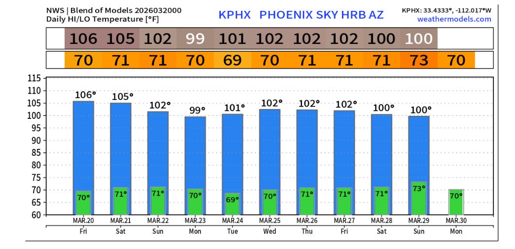
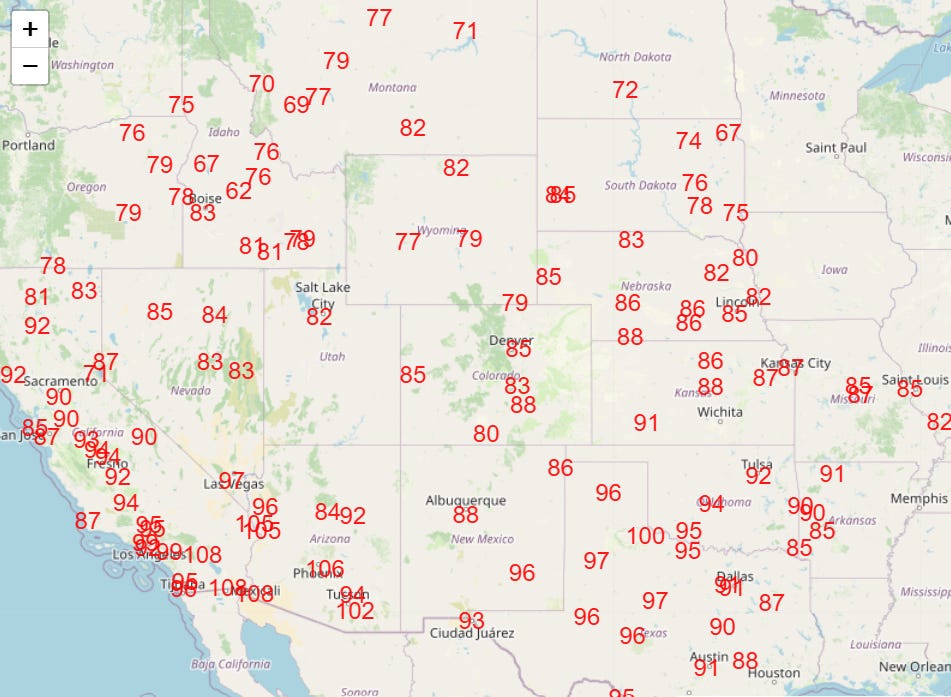
As an example of how this heat is expected to continue, Phoenix is forecast to be near or above 100F every day for the next 10 days. 100F was the monthly record for Phoenix prior to this heat wave — needless to say, having nearly two weeks of monthly record warm temperatures is truly astounding.
The other major weather story today is unfolding in Hawaii. After extremely heavy rainfall with a “kona low” weather pattern last weekend and early this week, the island chain is facing a repeat performance currently and into this weekend. An important aspect of a kona low pattern is that heavy rainfall occurs across the entire island chain, including western, leeward sides that are ordinarily much drier. These areas are particularly prone to flash flooding when this unusual heavy rainfall occurs.
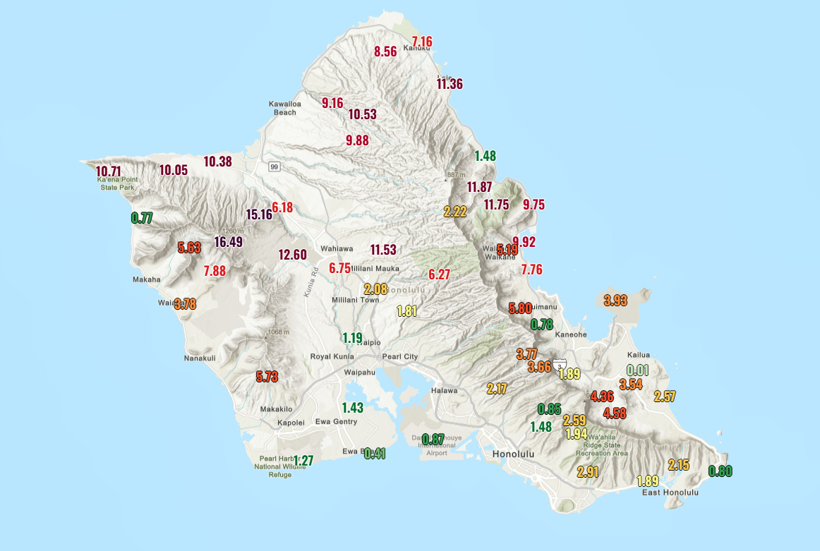
O’ahu is the island bearing the brunt of the issues currently, as tremendous rainfall of more than 10” fell overnight across the northern half of the island as seen in the 12-hour rainfall map above. With conditions already saturated from the rain of several days ago, this new rainfall is causing catastrophic flash flooding in some areas, and a flash flood emergency is in effect for this area.
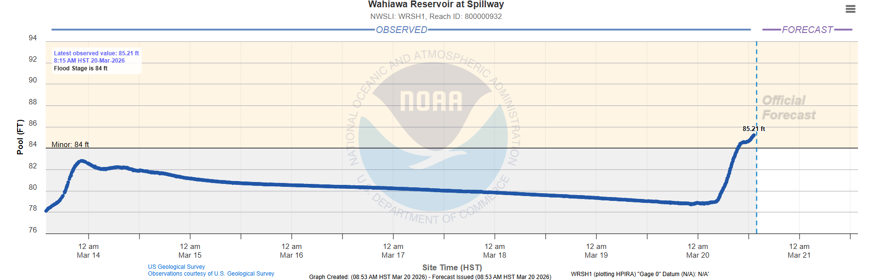
The water level on the Wahaiwa Reservoir in north central O’ahu has risen well above its critical level of 80’, and state and local officials are warning that the dam for the reservoir is at imminent risk of failure.
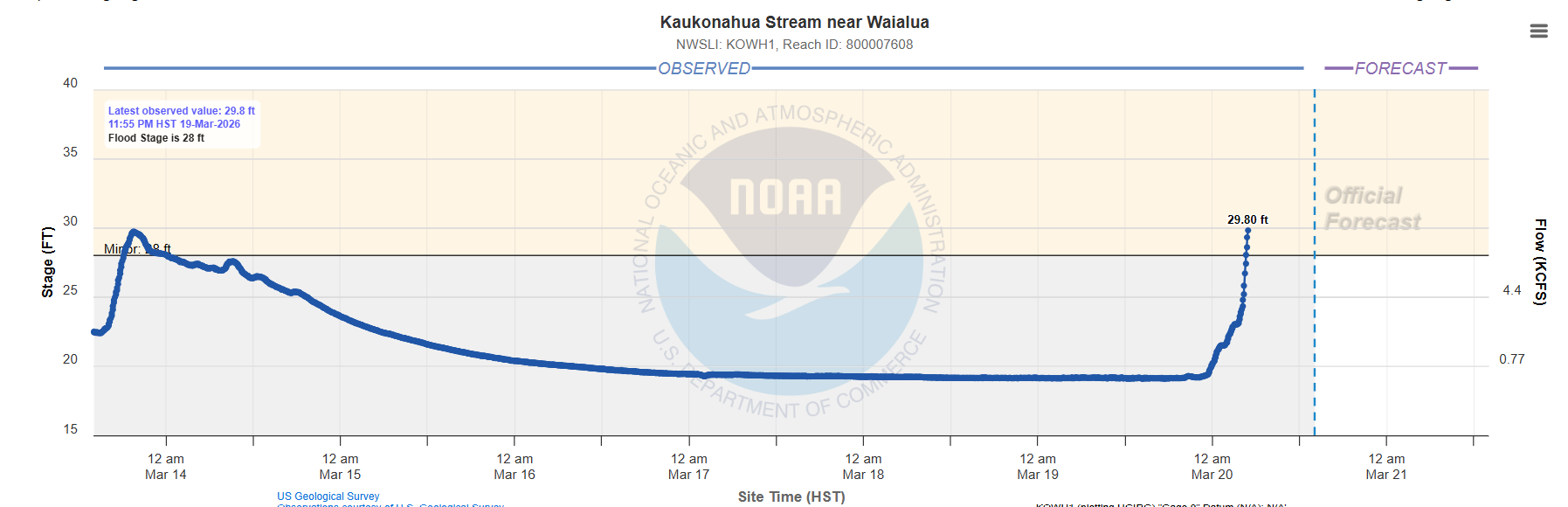
Flooding is already occurring along the Kaukonahua Stream below the dam with the gauge showing rapidly water rising levels. Obviously, this flooding will become catastrophic should the dam fail. Officials have ordered the evacuation of areas along the stream below the dam, including Waialua and Haleiwa.
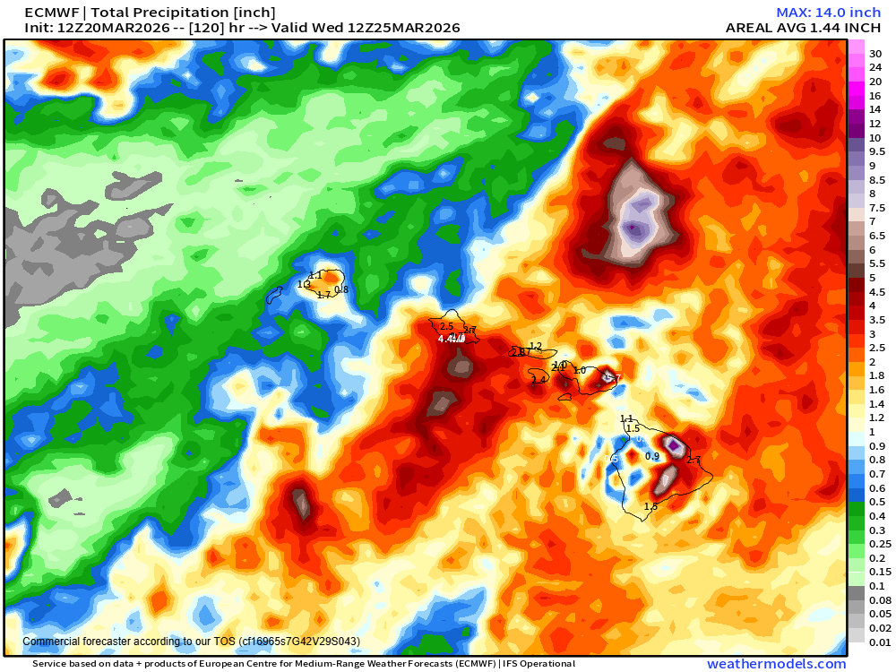
While rainfall has temporarily diminished across northern O’ahu, additional waves of heavy rainfall are anticipated across the western part of the Hawaiian Islands through the weekend, with heavier rainfall expected to shift east toward the Big Island with time. A flood watch is in effect for the entire state through Sunday.
More to come on both of these major weather stories through the weekend.

Leave a comment