Another national heat record for March likely set on Friday, as historic warmth expands east
Mar 21, 2026
")
With two massive weather stories ongoing today, it was hard to know where to start this newsletter — but decided I had to go with the catastrophic flooding impacting Hawai’i.
Hawai’i has been inundated with torrential rainfall over the last two weeks by a series of storm systems in a prolonged “kona low” pattern. For most of the year, the weather pattern in tropical Hawai’i is dominated by the easterly trade winds, in which weather disturbances move east to west and most of the rainfall tends to fall on the windward, eastern sides of each island. During winter, though, the jet stream can dip far enough south to cause west to east moving weather systems to impact the islands. With the prevailing winds coming from the opposite direction from the normal trade winds, heavy rainfall is prevalent on the leeward — or “kona” — western side of the islands, which is why the weather pattern is called a “kona low.” Because the leeward sides of the islands are usually much drier, they are particularly prone to flash flooding when heavy rainfall does impact them.
NOAA satellites can track the total moisture (precipitable water), and in this 12-hourly loop dating back to March 10th (courtesy NOAA NESDIS), we can see that a plume of deep moisture from near the equator has been transported northeast and stuck across the Hawaiian Islands. As low pressure systems and upper level disturbances pass northwest of the islands, waves of thunderstorms producing heavy rainfall have moved northeast through this moisture plume across the islands.
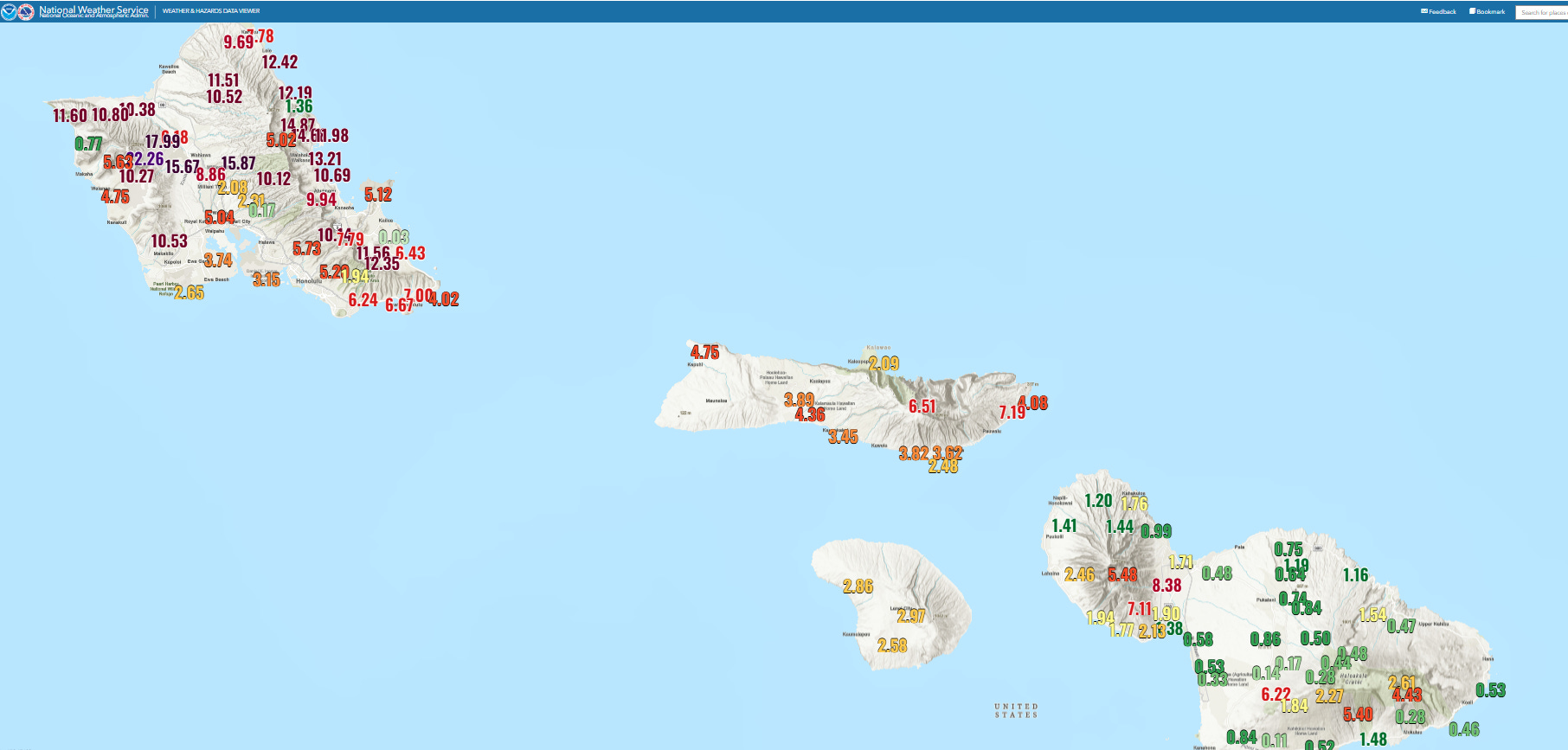
The initial multi-day wave of storms produced heavy rainfall and flooding (along with high winds that caused extensive power outages) across all of the islands, with Mau’i and Hawai’i bearing the heaviest rain and most significant flooding. This most recent wave of storms has been most focused on O’ahu, and particularly northern O’ahu with 48-hour rainfall totals of up to nearly 2 feet.
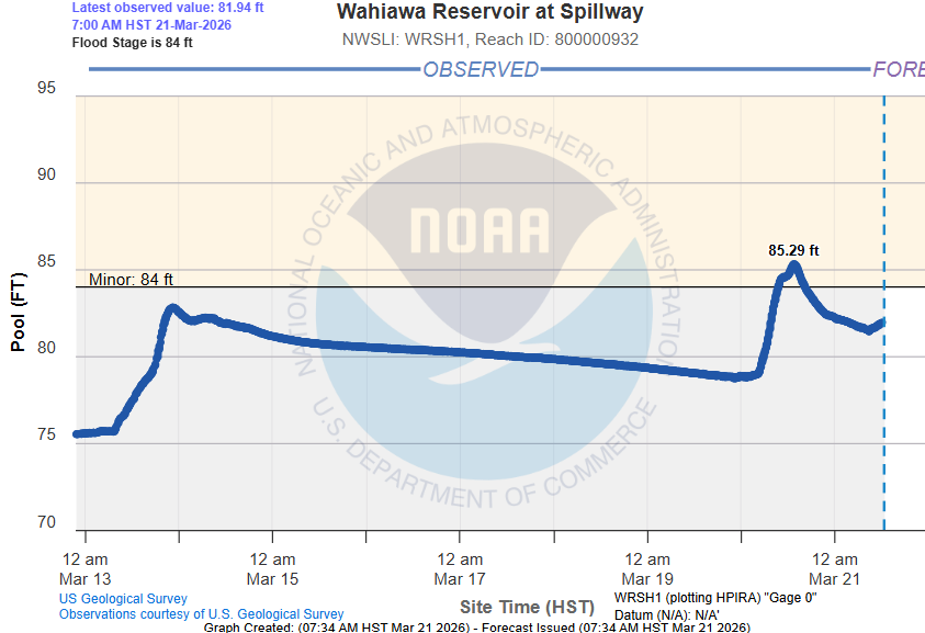
With conditions already saturated and water levels high after the initial wave of heavy rain several days ago, this torrential rainfall resulted in areas of catastrophic flash flooding across the island. Particularly impacted was the Wahiawa Reservoir and areas below its dam along the Kaukonahua Stream. The level of the reservoir rose well above its critical stage of 80’ (above), threatening the integrity of the dam and resulting in serious flooding downstream, including areas of Waialua (pictured at the top of this article) and Haleiwa, which remain under evacuation orders.
State officials report that more than 200 people have had to be rescued from flood waters. Per Hawaii News Now, this included “Hawaii National Guard teams evacuated or rescued about 50 residents of Haleiwa and Waialua beginning around 2:30 a.m., and later rescued 32 keiki (children) and 15 adults from a spring break camping area using Black Hawk helicopters.” Hawaii Governor Josh Green said in a media briefing that total statewide damage may exceed $1B.
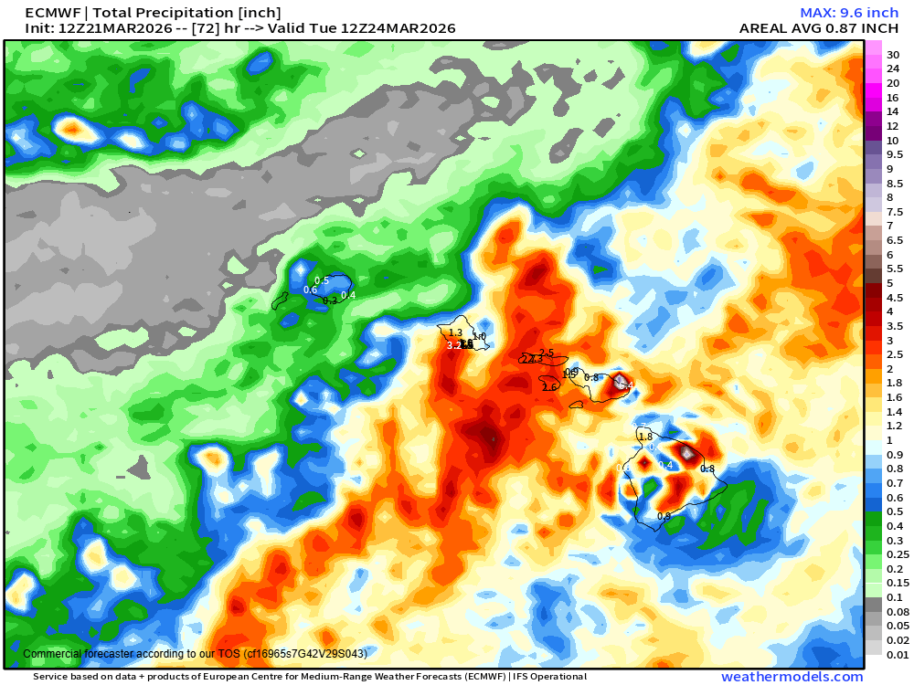
The strongest storms and heaviest rainfall this morning have been across Lanai and Moloka’i, although some heavier showers have occurred on O’ahu as well. Waves of showers and storms with heavy rain are expected to continue through the weekend, with flood watches in effect statewide. The heaviest rainfall looks to continue to be focused across the central part of the island chain the next 48 hours while heavier showers also expand east toward the Big Island into early next week. Conditions are expected to begin improving from west to east next week.
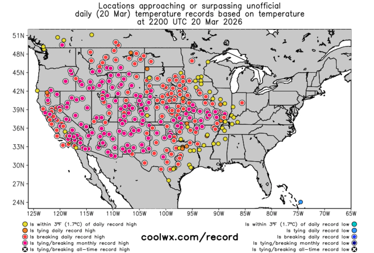
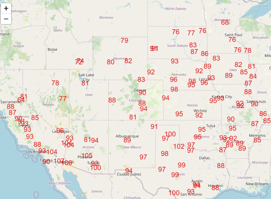
The other major weather story today is of course the record March heatwave, which is illustrated by one of the most incredible weather related maps you will ever see, courtesy of CoolWx.com. This map shows all of the locations that were at or above record high temperatures at 5 pm CT last evening, with all of the purple dots — from California to Illinois — at or above their monthly record.
While the establishment of a new March national record was a bit uncertain Thursday as the site exceeding the record (108F) was not a mainline climate site, a new record looks assured now as the Yuma, AZ climate site hit 109F on Friday. As reported by the climatologist Extreme Temperatures around the World, 8 states — California, Arizona, New Mexico, Nevada, Utah, Missouri, Wyoming and Idaho — saw potential state March record high temperatures on Friday.
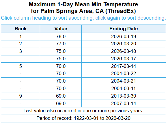
I have been reporting mainly on the extreme record high temperatures the last few days, but as is pointed out by the same (excellent) climate site, the record warm minimum temperatures have also been insane. Palm Springs is a particularly impressive example. Coming into this heat event, the record warm minimum for March at this site was 70F. It has been 75F or warmer the last four mornings, with the warmest minimum of 78F on Thursday.
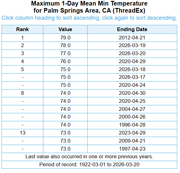
All four of these mornings would be in the top 10 record warmest minimum temperatures for April, and the 78F on Thursday would just be a degree short of equalling the record for that month.
Today will be another day of incredible record warmth for the western half of the country, before a slight contraction and cooling (but still a period of extreme, record warmth for much of the West) into the start of next week.

Leave a comment