And relief is not in store until next week
Mar 25, 2026
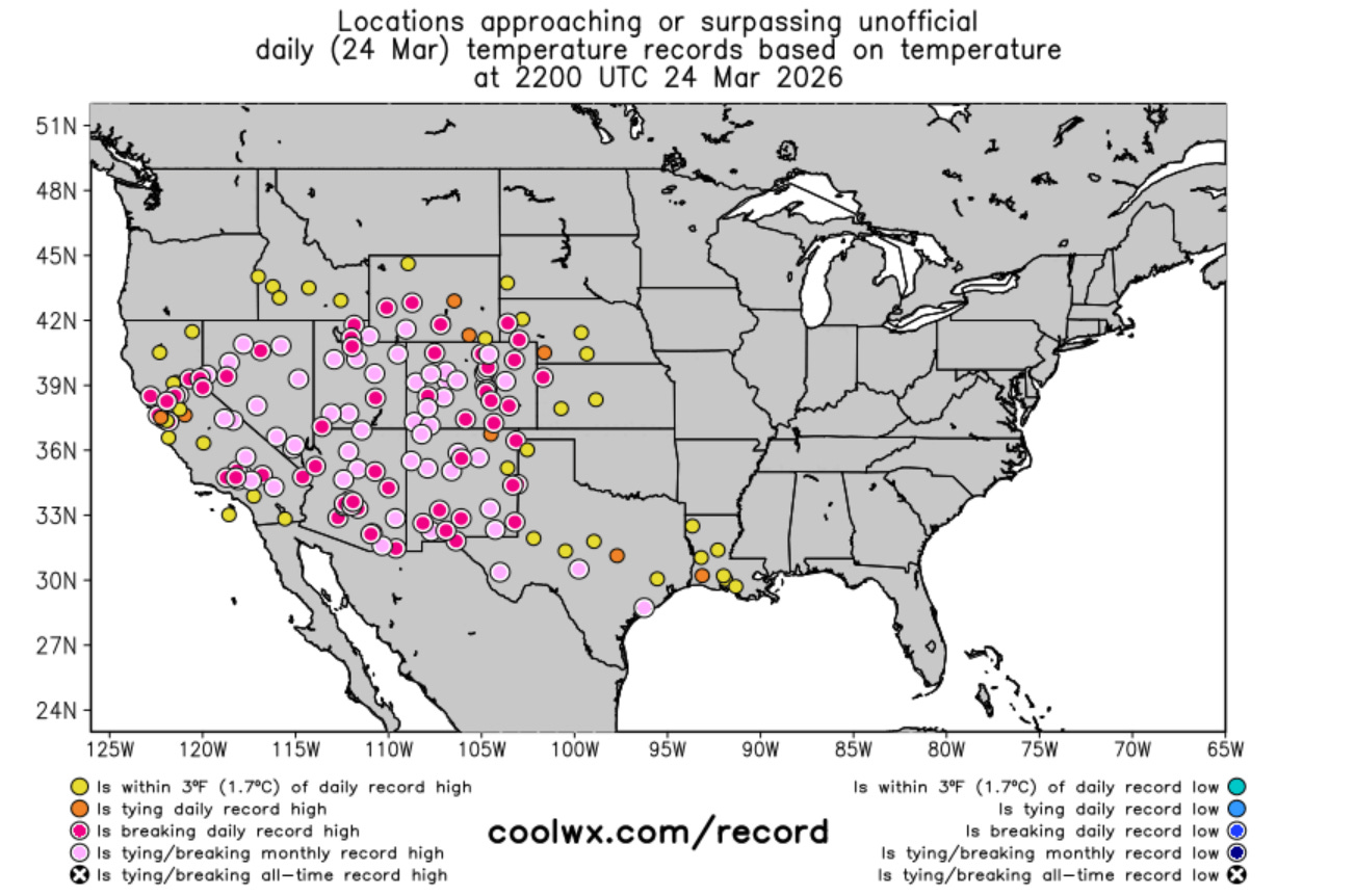
Happy hump day! The incredible record warmth went on for another day over much of the western United States on Tuesday. Many locations once again reached or exceeded what was their all-time record temperature for March coming into this historic heat event.
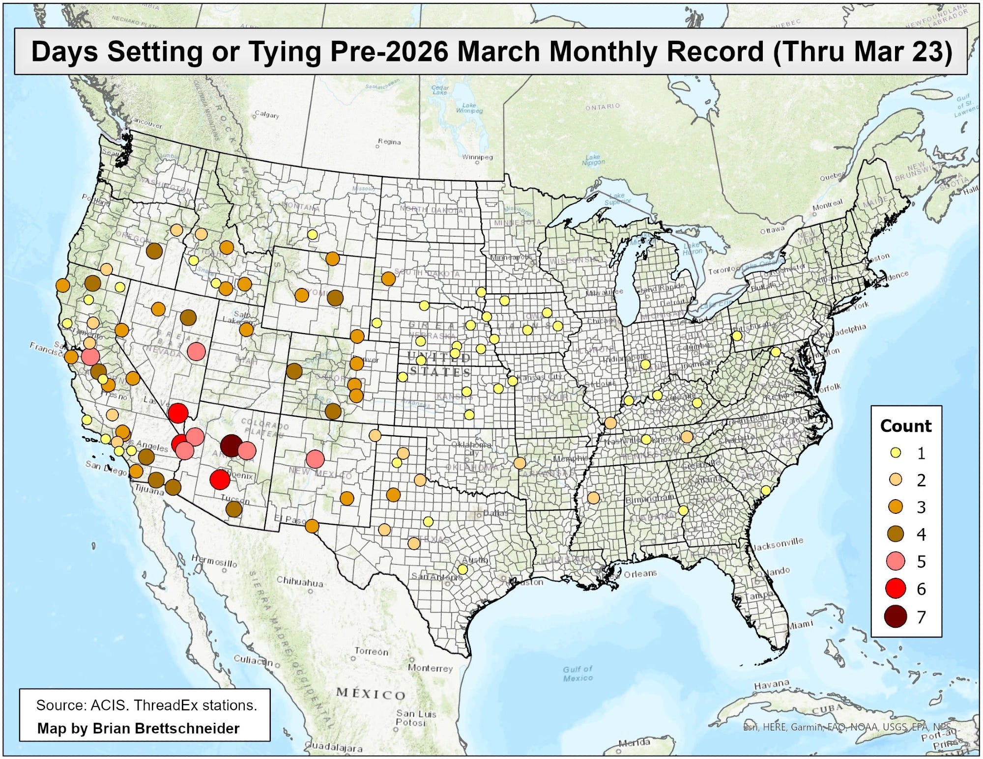
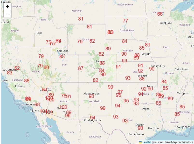
This excellent map from climatologist Brian Brettschneider shows the sites that have tied or set new March temperature records during this heat event as of Monday — and the number of times they have reached that temperature level. Obviously, reaching an all-time monthly record for a long term climate site is a rare event ordinarily — so the fact that we even need this map demonstrates the historic insanity of this period of abnormal warmth.
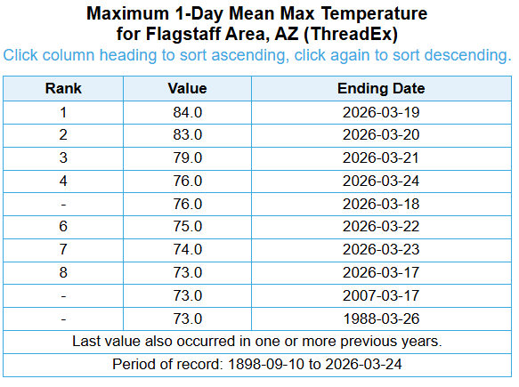
Flagstaff, AZ continues to be ground zero. Prior to 2026, the all-time record high for March was 73F. This site has now reached or exceeded that temperature eight consecutive days. On two days it exceeded the all-time April record of 80F.
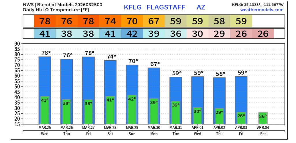
The current forecast indicates at least four more days will be added to this streak before some cooler air finally works into the region, particularly after Monday. The high of 70F on Sunday would still be a record daily high — so if the forecast verifies, Flagstaff will have had a daily record high on 13 consecutive days.
To give some perspective, Brian Brettschneider noted on Bluesky that only four other long term climate sites have ever had streaks that long or longer, with the record being 21 days at Phoenix in 2024. All of these other sites streaks have been since 2019 except Burlington, IA in the Dust Bowl year of 1936. Of course, what makes the potential consecutive record day streak at Flagstaff extra impressive is that 12 of the 13 days saw not just daily record highs, they saw high temperatures at or above the prior monthly record. Incredible (and alarming) stuff.
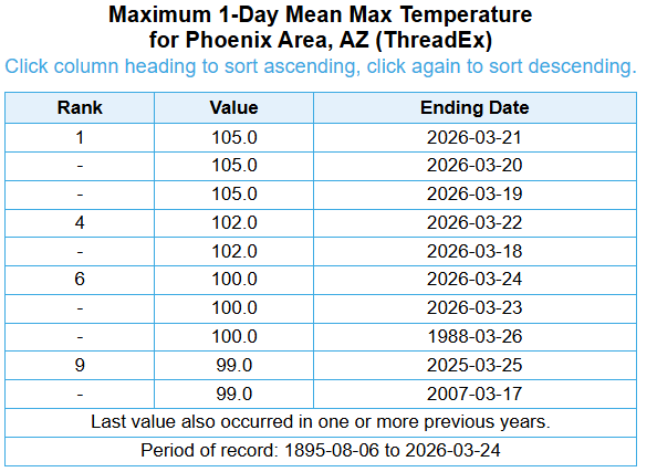
Phoenix is right behind Flagstaff with a week of consecutive days at or above the prior March record high. This seven day string of temperatures at or above 100F is also longer than any 100F degree streak observed in April. As you can see in Brian’s map, while Arizona has been the core of this anomalous heatwave, numerous locations in surrounding states have reached their March record on multiple days, showing the incredible strength and persistence of this warmth.
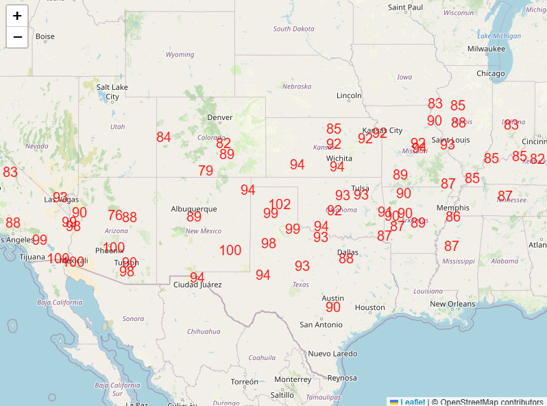
The record warmth will intensify and expand east again the next couple of days, with highs in the 80s and 90s building east again across the Midwest and Ohio Valley.
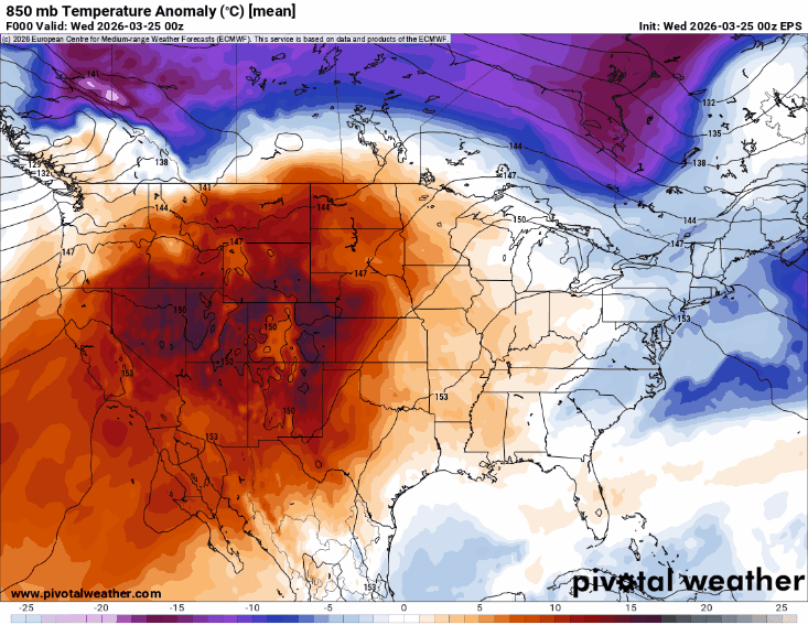
This 10-day temperature anomaly animation shows how after this surge of warmth east over the next couple of days, a new cold front will drop south across the eastern US, bringing cooler air and indeed a shot of much below normal temperatures to the Northeast. However, this looks relatively short lived as a shift in the weather pattern will result in an upper level area of high pressure building across the eastern United States later next week, resulting in well above normal temperatures. Meanwhile, an upper level trough will finally move into the Pacific coast, bringing a few days of cooler and wetter conditions to the West.
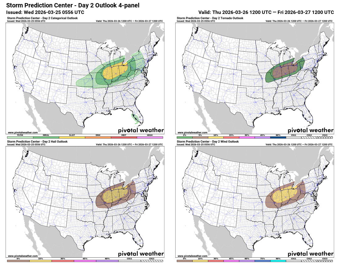
In the meantime, the cold front moving south out of Canada will bring a slight (level 2 of 5) risk of severe storms to the lower Great Lakes region Thursday afternoon and evening, with some supercell storms capable of hail, strong winds and a few tornadoes expected. Warm, dry air and gusty winds will also bring elevated to critical fire danger to parts of the Rockies and Plains the next couple of days.
Programming note: My daughter works for the Texas Children’s Hospital, and I will be volunteering at their PGA Tour event through this weekend. As a result, my posts will be less frequent and off schedule the next several days.

Leave a comment