On flip side, Alaska sets all-time cold records for March. As April kicks off, severe weather risks continue to ramp up.
Apr 01, 2026
Welcome to a new month, and while it will take a bit of time to get final national and global numbers for March climate statistics, some statistics are starting to roll in that show the incredible anomaly that was March 2026.
Thanks to the climatologist M. Herrera for sharing on BlueSky yesterday the factoid from Las Vegas meteorologist Justin Bruce that Las Vegas was likely to not only shatter the record for its warmest March on temperature — but that the average March temperature would likely be warmer than any April on record in Las Vegas.
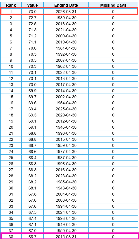
The final numbers are in, and indeed with an average temperature of 73.0F, March 2026 in Las Vegas was 0.3F warmer than any April on record, besting the previous record of 72.7F in 1989. In this table of warmest Marches and Aprils from the NOAA regional climate centers site XM-ACIS, you can see that you have to go down to #38 to find the next March on the list, 2015. With an average temperature of 66.7F, that was the prior record warmest March in Las Vegas, so 2026 set a new record by an astonishing 6.3F.
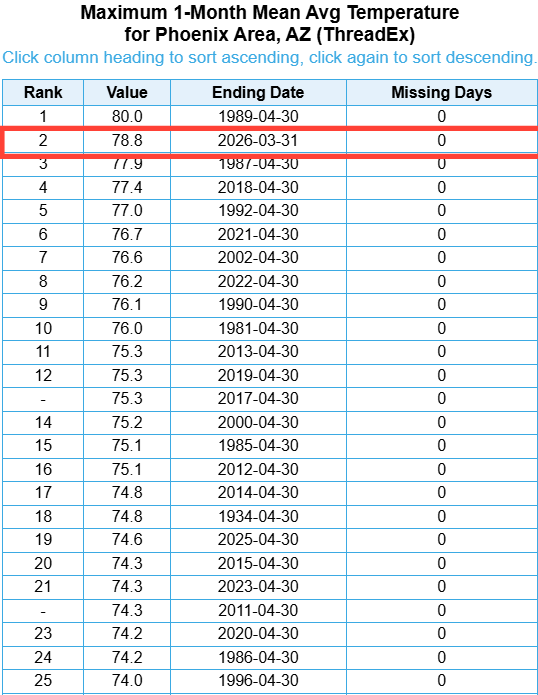
March 2026 in Phoenix did not quite beat any April for warmth — but it would be the runner-up. No other March would be in the top 25 for warmest Aprils in Phoenix, and in fact you have to go to #41 to find March 2004, the previous record warm March with an average temperature of 72.3F. April 2026 shattered that record by 6.5F.
In looking at other sites around the Southwest (e.g., Albuquerque, Yuma, Flagstaff, Needles, Palm Springs), March 2026 would be in the top 5 when stacked against warmest months of April. I just cannot overstate how truly insane this is. We are transitioning from winter to summer at this time of year, i.e., the normal high and low temperatures are trending warmer each day. To even have a single location reach a daily maximum temperature in March that would also set a monthly record for April is incredibly impressive. To have a long term climate site like Las Vegas have its monthly average temperature for March be warmer than any previous April is incredible — and to have most long term climate sites in the region have March 2026 be warm enough to be in the top handful of prior Aprils is further proof of the truly singular climatic event we have just witnessed.
At a national level it remains to be seen if March 2026 will beat out March 2012 — a year in which the Great Lakes region had what I consider my initial “canary in the coal mine” climate event with extreme climate change driven warmth — as the warmest March on record.
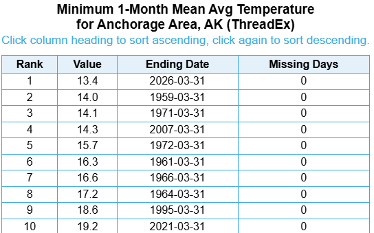
While the contiguous United States was basking in this incredible warmth, I do want to stress that the 49th state was finishing one of the coldest winters it has seen in years. Anchorage set an all-time March monthly record for coldest average temperature — and Alaska based climatologist Brian Brettschneider pointed out that March 2026 will be the coldest month of the cold season in Anchorage for the first time since the winter of 1960-1.
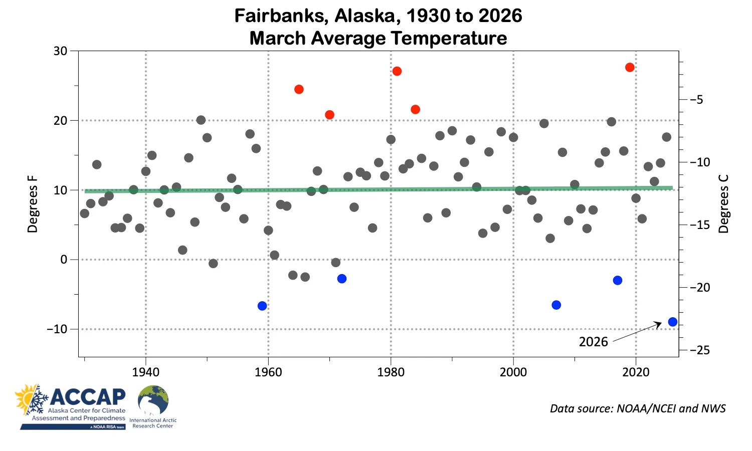
This unusually cold March (and winter) was observed over much of the state, with Fairbanks also setting a new monthly record for coldest March as shown in this graph from Alaska meteorologist Rick Thoman. Rick noted that this is the first monthly cold record set in Fairbanks since October 1996.
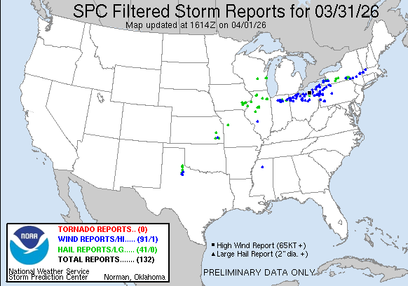
Yesterday saw a continued ramp up in the severe thunderstorm activity across the country, with the Great Lakes region being the focus of the severe storms. The most intense activity were bands of severe storms that moved east along and south of Lake Erie, producing numerous observed severe wind gusts of up to 75 mph.
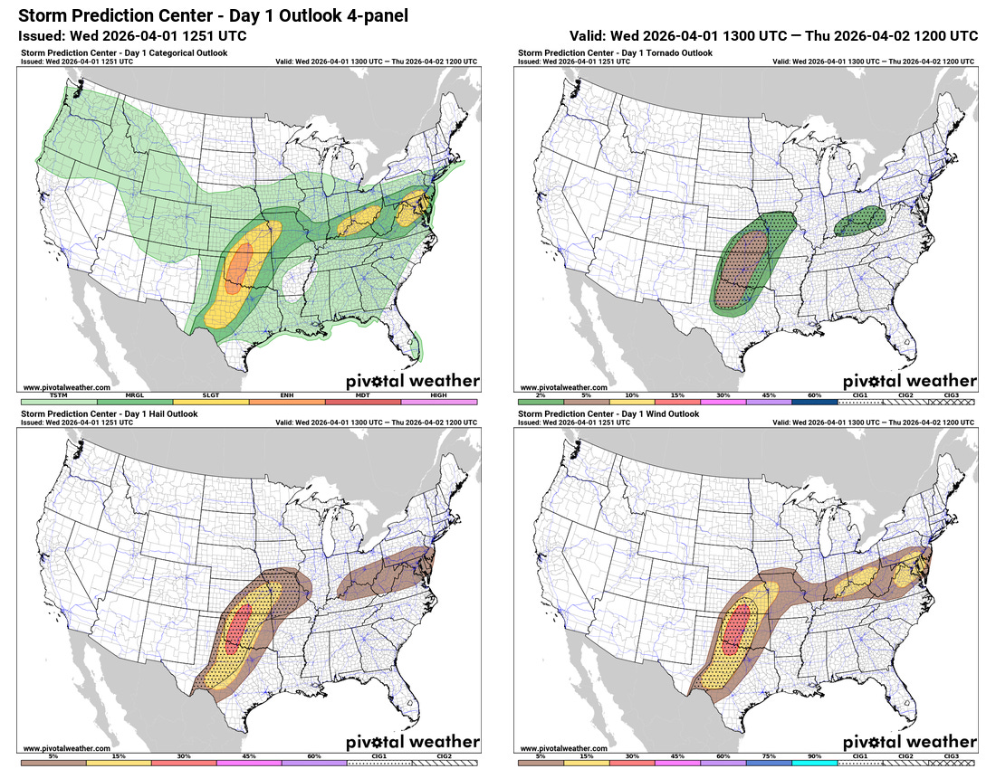
Today the focus of activity should shift to the central United States, where an upper level disturbance moving east and northeast across the region will spur the development of a storm system to the lee of the central Rockies. Supercell severe storms are expected to develop this afternoon along a front extending south of this low across the Southern Plains with a threat of very large hail and a few tornadoes. This activity should rapidly evolve into a line of severe storms that will move east toward the Interstate 35 corridor with an increasing risk of damaging wind gusts, along with large hail and possible tornadoes. Other strong to isolated severe storms will be possible today along the old front that produced the severe weather on Tuesday, which is now nearly stationary from the Midwest to the Mid-Atlantic.
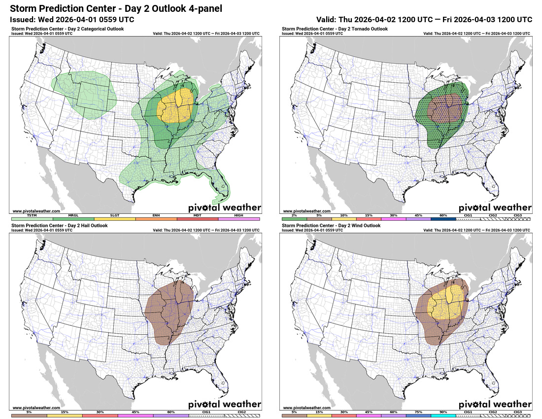
On Thursday, the risk of severe storms will shift to the Midwest and Great Lakes region as the low pressure system moves northeast. The Storm Prediction Center has a large slight (level 2 of 5) risk for severe storms in the region.
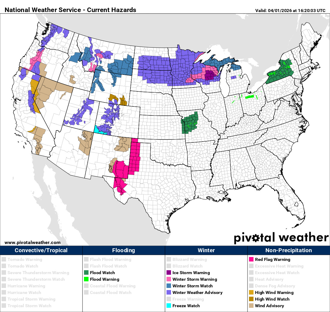
Severe weather is not the only hazardous weather risk with this storm system. Winter weather is anticipated to the north of the low, particularly over northern and central Wisconsin where significant freezing rain is anticipated the next couple of days. Some localized flash flooding is possible, particularly in parts of western Missouri where flash flood watches are in effect. Strong winds and increased fire danger are anticipated to the south and southwest of the low, and high wind warnings/advisories and red flag warnings are in place.
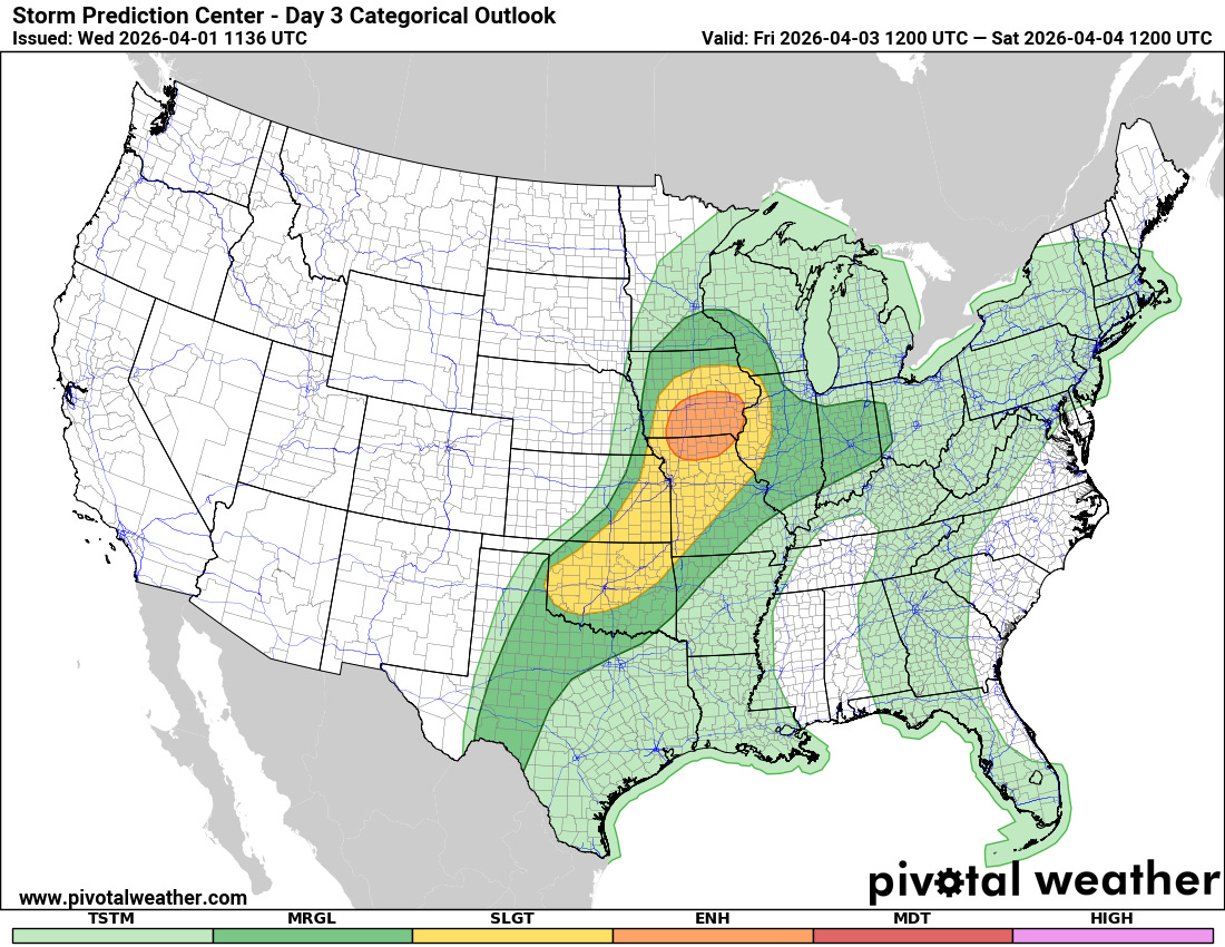
A new upper level disturbance and associated surface low moving through the Midwest on Friday will bring an additional risk of severe storms. The greatest risk of severe storms is over northern Missouri and southern Iowa where the Storm Prediction Center has an enhanced (level 3 of 5) risk of severe weather, with a slight (level 2 of 5) risk back southwest into Oklahoma along a trailing cold front. All modes of severe weather including tornadoes will be possible with severe storms Friday afternoon and evening.

Leave a comment