Dr. Phil Klotzbach presents the initial Atlantic hurricane seasonal outlook
Apr 09, 2026
I had the incredible opportunity this morning to get the first major seasonal hurricane outlook for 2026 straight from the horse’s mouth. Dr. Phil Klotzbach, the scientist who took over as the lead for the renowned Colorado State University’s Tropical Cyclone Research and Forecasting Project after the retirement of pioneering scientist Dr. William Gray, gave a presentation at the National Tropical Weather Conference this morning detailing his team’s initial expectations for the 2026 Atlantic hurricane season.
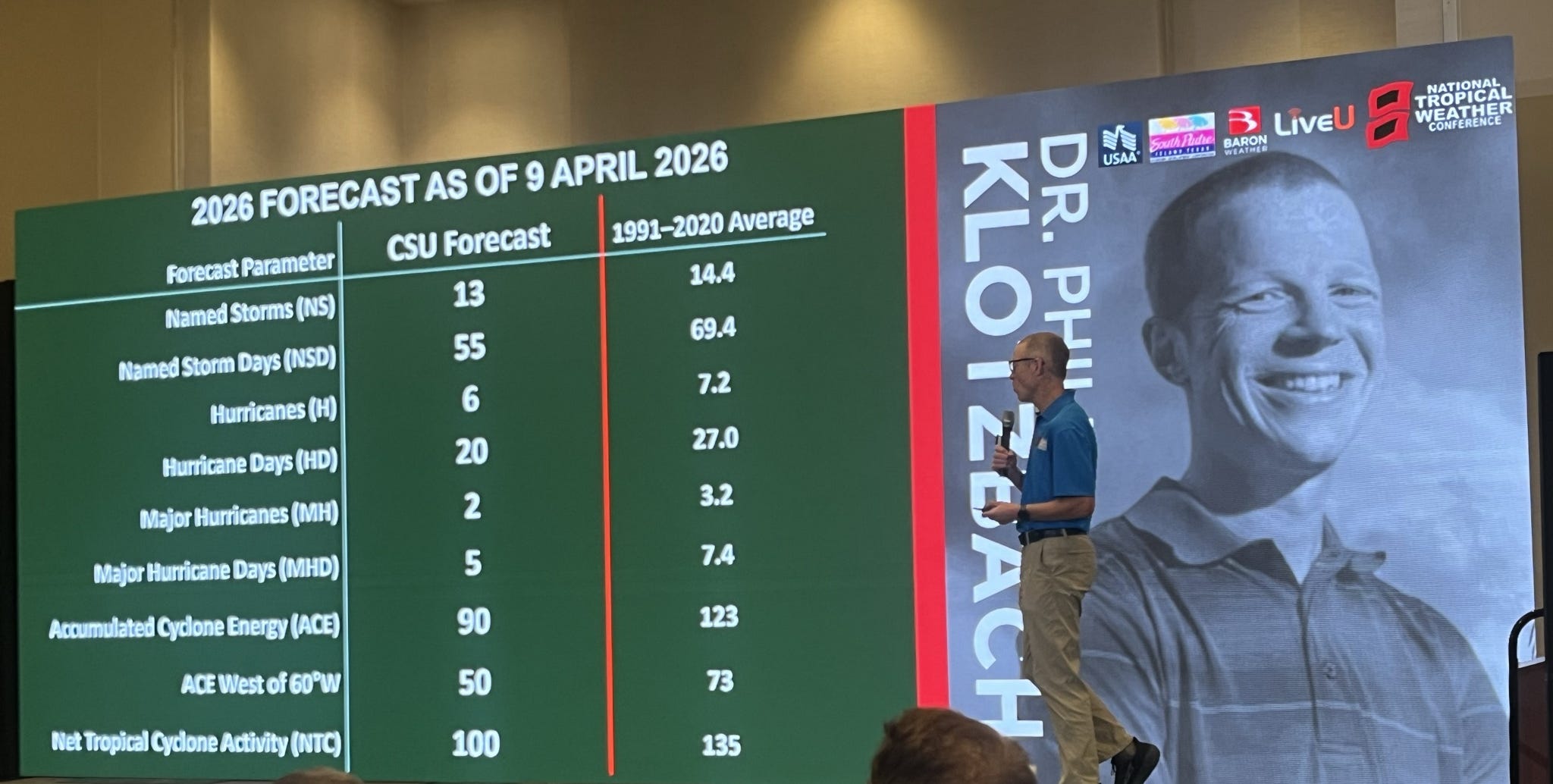
As summarized in the picture above, the forecast is for a slightly below normal season, with 6 hurricanes (normal is 7.2), 2 major hurricanes (normal is 3), and an Accumulated Cyclone Energy (ACE, a measure of total tropical activity taking into account the longevity and intensity of systems) of 90, in comparison to the normal 123.
A big player in the level of Atlantic tropical activity is the phase of the El Nino Southern Oscillation (ENSO), i.e., whether or not there is a La Nina (increased hurricane activity) or El Nino (decreased hurricane activity). There has obviously a lot of talk in recent days about a developing El Nino, and today the NOAA/NWS Climate Prediction Center officially declared that this winter’s La Nina episode has ended and that there is about a 90% chance of El Nino developing later this year. This is a big factor in the CSU team’s forecast of a somewhat below normal season.
While an El Nino event is quite likely, in spite of what you may be seeing in media reports there is no guarantee that this will be a “super” or even a strong El Nino. As Dr. Klotzbach noted in his talk today, there is a well known “spring predictability barrier” that climate models deal with in forecasting ENSO phase later in the year, and there have been plenty of examples of where models at this time of year overforecast the intensity of El Nino for later in the year.
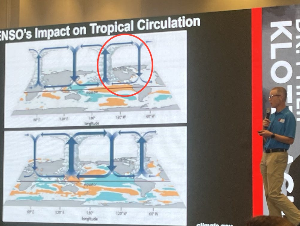
El Nino has a detrimental impact on the Atlantic hurricane season because it supports a much more active pattern of thunderstorms in the eastern Pacific – and downstream of all of that rising air, there is sinking air over the Atlantic which is not favorable for development. It also supports stronger westerly winds aloft which results in more detrimental wind shear. However, a stronger El Nino has much more impact than a weak El Nino — so if the El Nino is not that strong, it will not be as big of a negative on this season.
And while all atmospheric and oceanic signs currently point to the formation of an El Nino, when exactly that occurs is critical — a quicker transition will obviously mean a more likely impact on this season. Furthermore, the atmosphere doesn’t immediately respond to the oceanic changes, and the timing of that atmospheric response is also crucial for the Atlantic hurricane season.
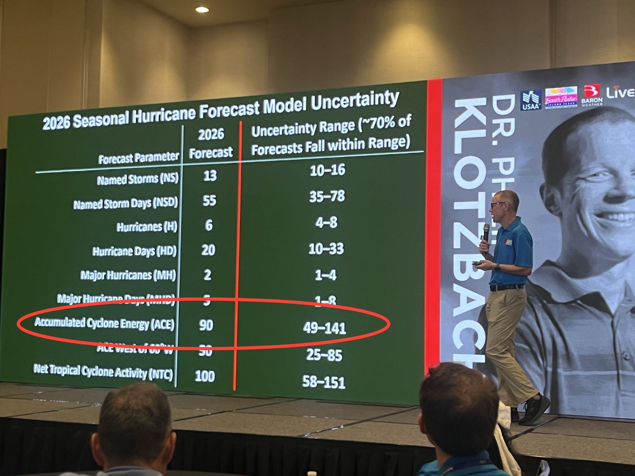
The bottom line is that based on the current uncertainty in the ENSO forecast and other important atmospheric factors the team looks at, CSU is currently only forecasting the season to be a bit below normal in spite of the El Nino. Obviously, all of the uncertain factors I talked about above mean there is a lot of spread in the possible outcomes. This can best be seen in the uncertainty range of the ACE forecast above, which is based on the average error of past April seasonal outlooks. You can see that the actual ACE for this year could vary from 49 to 141 within the “normal” error for an April forecast. As Dr. Klotzbach noted, 49 would be an unusually inactive season, while 141 would be an above normal season based on NOAA definitions.
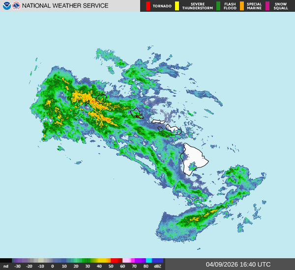
One final note is that while suppressing activity in the tropical Atlantic, El Nino enhances activity in the tropical central and eastern Pacific. So the ENSO evolution will also have a big influence on any potential tropical activity that might impact Hawai’i this season. This is particularly important given that Hawai’i is already dealing with the aftermath of multiple intense Kona low storms the last several weeks, including one that is impacting the state today. High wind warnings and flood watches are in effect for large parts of the state as waves of heavy showers and strong thunderstorms are expected through Friday.

Leave a comment