Supertyphoon Sinlaku continues to pose a serious risk to the Northern Mariana Islands – while the eastern US looks to set hundreds of new record warm temperatures this week.
Apr 13, 2026
Starting off this morning with a quick update on Supertyphoon Sinlaku. The satellite presentation of the cyclone is not quite as perfect as last night — it’s slightly more asymmetric and a little eroded. However, it is still an impressive typhoon with a warm, symmetric eye, and automated satellite algorithms continue to support the latest Joint Typhoon Warning Center advisory that shows Sinlaku having maximum sustained winds of 175 mph.
This radar mosaic loop from the NSSL Multi-radar Multi-sensor (MRMS) system (thanks to my colleague Ken Howard for sharing this) shows that the eye of Sinlaku has been moving steadily northwest over the last 6 hours toward the islands of Tinian and Saipan (upper left hand corner). The general motion toward these islands is expected to continue today, with the expectation that the core of an only slightly weaker Sinlaku will impact these islands later tonight into Tuesday morning (CONUS time).
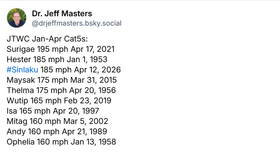
The estimated intensity of Sinlaku yesterday was adjusted slightly up to 185 mph, meaning that Sinlaku now equals Hester as the most intense western Pacific typhoon before mid-April as shown in this list from Dr. Jeff Masters.
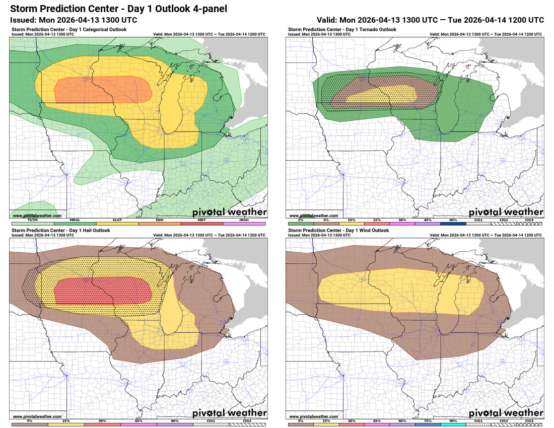
Back in the CONUS, today will be the start of an active week of severe weather threats across the country, with the next couple of days focused in the upper Midwest. A low pressure system moving across the region this afternoon and evening will interact with an increasingly moist and unstable atmosphere to produce scattered supercell severe storms. Conditions look prime for storms with very large hail, which the NWS Storm Prediction Center (SPC) is highlighting with an enhanced (level 3 of 5) risk of severe weather. A few tornadoes are also possible — and as we saw with the period of severe weather back in early March, a warm front lying east-west along the Iowa/Minnesota border into central Wisconsin could provide a particularly favorable environment for tornadoes for any storms that can move east along the front. SPC has an enhanced risk for tornadoes, which could potentially be strong, in this region as shown by the yellow area in the upper right graphic above.
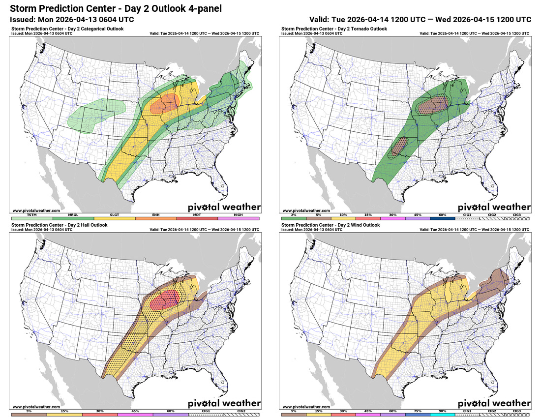
The front associated with this storm system will hang up from the Great Lakes to the Southern Plains as an intense upper level high pressure system along the East Coast will keep it from progressing any farther east. The atmosphere along this boundary will be very unstable for mid-April, and as another upper level disturbance moves across the Upper Midwest additional supercell severe storms capable of producing very large hail and a few tornadoes are anticipated on Tuesday afternoon and evening. SPC has another enhanced (level 3 of 5) risk of severe storms in this area. A slight (level 2 of 5) risk extends farther to the southwest where the developments of storms will be more uncertain — but if storms develop, the atmosphere will be favorable for severe storms with large hail, damaging straight line winds and possibly a few tornadoes.

As this front remains hung up and upper level disturbances rotate northeast along it, additional threats of severe storms are anticipated later this week as shown in the National Center for Atmospheric Research AI-derived severe weather probabilities for the upcoming week. Friday in particular looks like to a day to keep a close eye on as the models have trended stronger with a system that will move east across the Midwest and eventually force a cold front into the East this weekend.
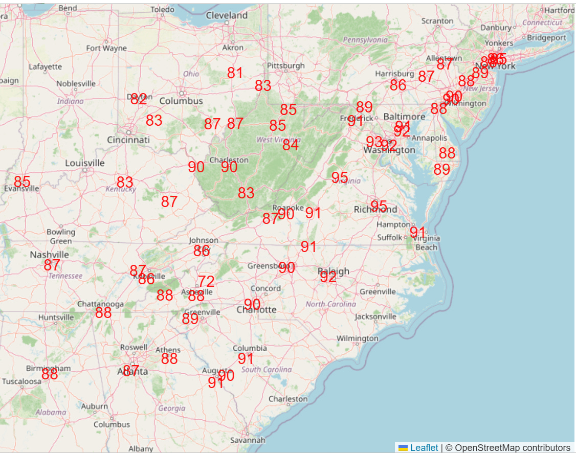
Ahead of this cold front, multiple days of widespread record warmth is expected, with hundreds of new record warm temperatures — both daily maximums and warm minimums — expected. Wednesday (NWS forecast record highs shown above) will see an initial peak of widespread warmth, with another surge expected over the weekend ahead of the cold front.

Leave a comment