Beware the Ides of March
The atmosphere is – very unfortunately – providing me with a lot of opportunity to talk about it in a compelling way for my first weather post on Balanced Weather. After one of the more active days in recent memory with significant tornadoes, dust storms, high winds and wildfires on Friday, today promises to be another extremely busy day in the weather world. Let’s break it down – and apologies up front, this first post will be a long one with everything going on.
Rare High Risk of Severe Weather
Bottom line up front: today is a potential tornado outbreak day in Mississippi, Alabama, and middle Tennessee, and people in those areas need to be vigilant and ready to take protective action quickly.
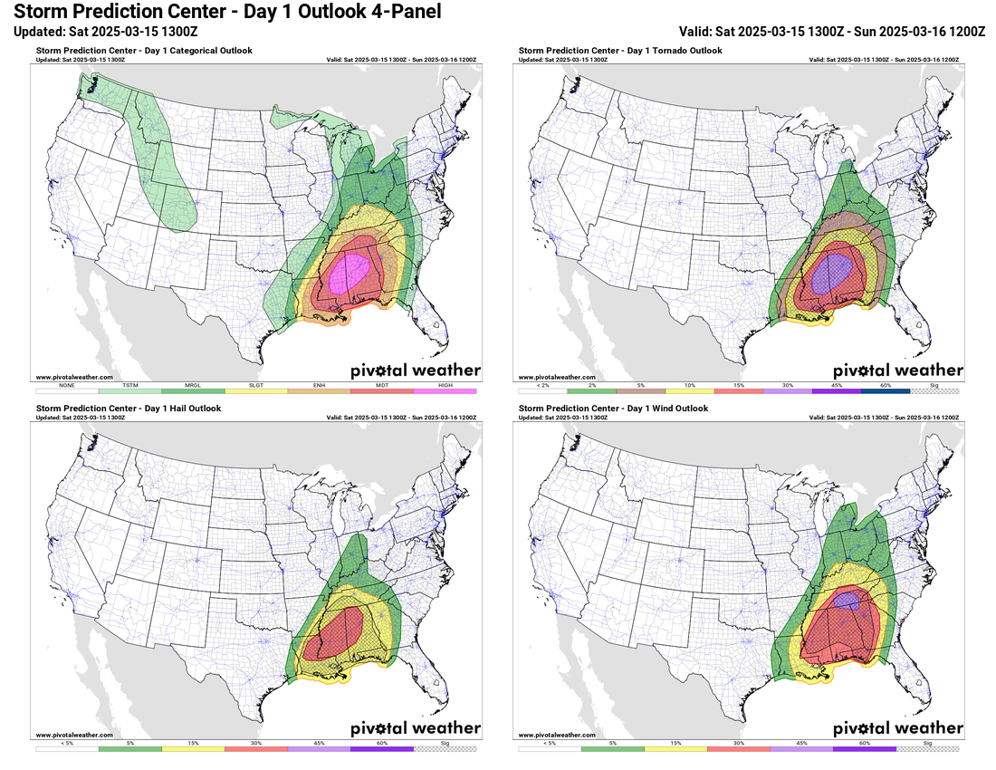
The Storm Prediction Center (SPC) has issued a high (level 5 of 5) risk of severe thunderstorms today across eastern Mississippi and western and northern Alabama. The maps above show the total “categorical” severe weather risk in the upper left, and then clockwise from there the probabilistic outlooks for tornadoes, wind and hail. The driver for the high risk is the tornado forecast. As a quick introduction, SPC probabilistic outlooks forecast the probability of an event occurring with 25 miles of a given point. The 30% tornado probability area here indicates an unusually high risk (hence the high risk); the hatching means along with the 30% probability of a tornado there is also a 10% or greater possibility that if a tornado occurs, it will be strong or violent (EF2 to EF5).
That’s the science background; the bottom line summary is that a major outbreak of severe thunderstorms producing long track, intense tornadoes as well as large hail and swaths of damaging straight line winds are likely for much of Mississippi, Alabama and Tennessee today. As the sun rises this morning, there are already tornado watches and a number of severe t-storm/tornado warned storms from the Arklamiss into the mid-South (see below).

Above: MRMS radar mosaic at 8 am CT Saturday
Below: NWS Hazards Summary at 8 am CT Saturday

Conditions are already extremely favorable for severe weather across the region this morning. The morning weather balloon released at 7 am CT at Jackson demonstrates this:
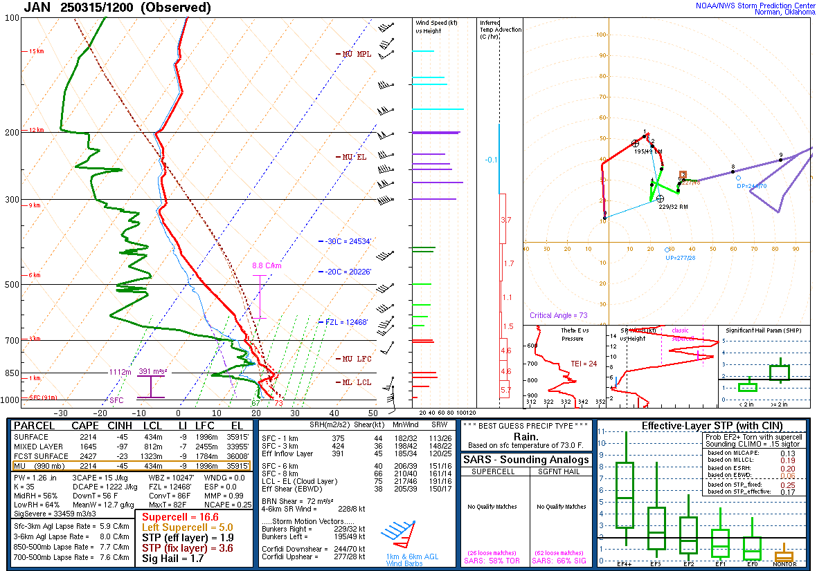
This is the summary “Skew-T” chart from this balloon release, and it shows a classic “loaded-gun” sounding indicative of a very favorable atmosphere for severe weather: a very moist and warm near the surface with colder, drier aloft that will provide extremely unstable air for storms to feed off. The wind shear – the change in wind with height in the atmosphere – is already quite strong and will only get stronger today as another intense impulse in middle and upper levels of the atmosphere moves into the region.
As far as timing, the risk of severe weather will gradually ramp up and spread east from where it is currently, and peak in the moderate and high risk areas later this afternoon into the early evening. The risk will continue to spread east/southeast into Georgia and the Florida Panhandle overnight, and often in the Southeast there is a secondary ramp up in tornado potential after midnight that those areas will need to be alert to.
Flash flooding also a significant risk today
In addition to the severe weather risk, flash flooding will also be a major concern, especially in the Tennessee Valley where the Weather Prediction Center has issued a moderate risk for flash flooding.
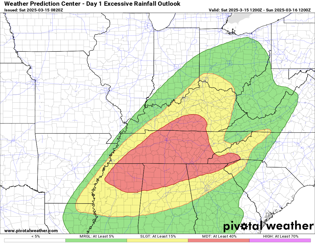
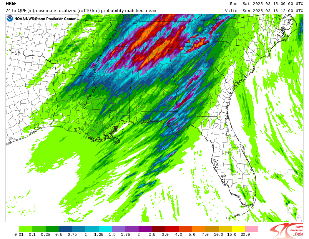
As several waves of intense storms move repeatedly over the same areas, flash flooding will become an increasing concern later this afternoon and evening. The High Resolution Ensemble Forecast (HREF) – several fine-scale atmospheric models that are combined to provide meteorologists with probabilistic forecasts – shows the potential for swaths of 5-10” of rain in the moderate risk area
.The Tennessee Valley region is particularly prone to flash flooding due to the terrain and we are still early enough in the year that a lot of the rain will runoff, exacerbating flash flood potential.
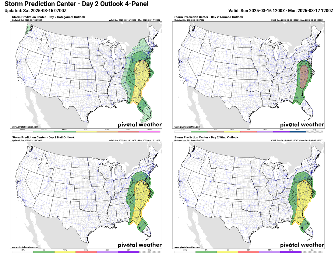
Severe Weather Risk Sunday
Finally, I don’t want to leave out that as this system continues to push east on Sunday, there will be an additional risk of severe storms from the Mid-Atlantic into the Carolinas and northwest Florida. SPC has a slight (level 2 of 5) risk out, with the main area of tornado risk from central Virginia down into South Carolina.
Live Substack Chats Today
With the extremely active weather anticipated today, I will be taking the opportunity to test out using Substack Chats to provide ongoing updates about the severe weather and flash flooding; while Substack Chat is eventually planned to be a Balanced Weather paid subscriber benefit, for today in test mode it will be free to all subscribers. I will also be making occasional subscriber-only Substack posts and posts to social media of course as well.
I intend for this newsletter to cover a lot more in the way of more national weather and general meteorology topics – but there’s too much going on in the atmosphere today to focus on anything more than what’s happening currently. Hope everyone stays safe in the severe weather risk areas today – and I’ll be updating as the day goes on.

Leave a comment