Luckily, a pattern change lurks for next week that should bring some cooler and wetter weather to the West.
Feb 02, 2026
Happy Monday, welcome to a new work week. The last couple of weeks have pretty much been a barrage of weather, and with this week starting off on a bit of a quieter note, I want to use today’s newsletter to summarize and contextualize this period as well as talk about what looks to be on the horizon.
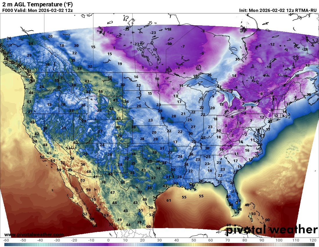
While temperatures were not as cold this morning as the last couple of days across the eastern United States, there were still widespread single digit readings across much of the Northeast and eastern Great Lakes regions, with subfreezing temperatures extending well south across Florida.
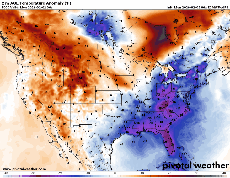
The overall weather pattern of a large upper level ridge of high pressure across the western United States, with a downstream trough of upper level low pressure across the East that we have been seeing for much of the last few weeks (and much of the cool season) will continue this week. As this animation of surface temperature anomalies (from the European AI model) for the next 7 days shows, this will continue to yield above normal temperatures for most of the western half of the country while shots of cold air continue to drop south across the East. However, with time, the warmth in the west will be gradually building farther east, and by the time the next major Arctic airmass drops south this weekend, the impacts will primarily be focused in the northeast quarter of the nation.
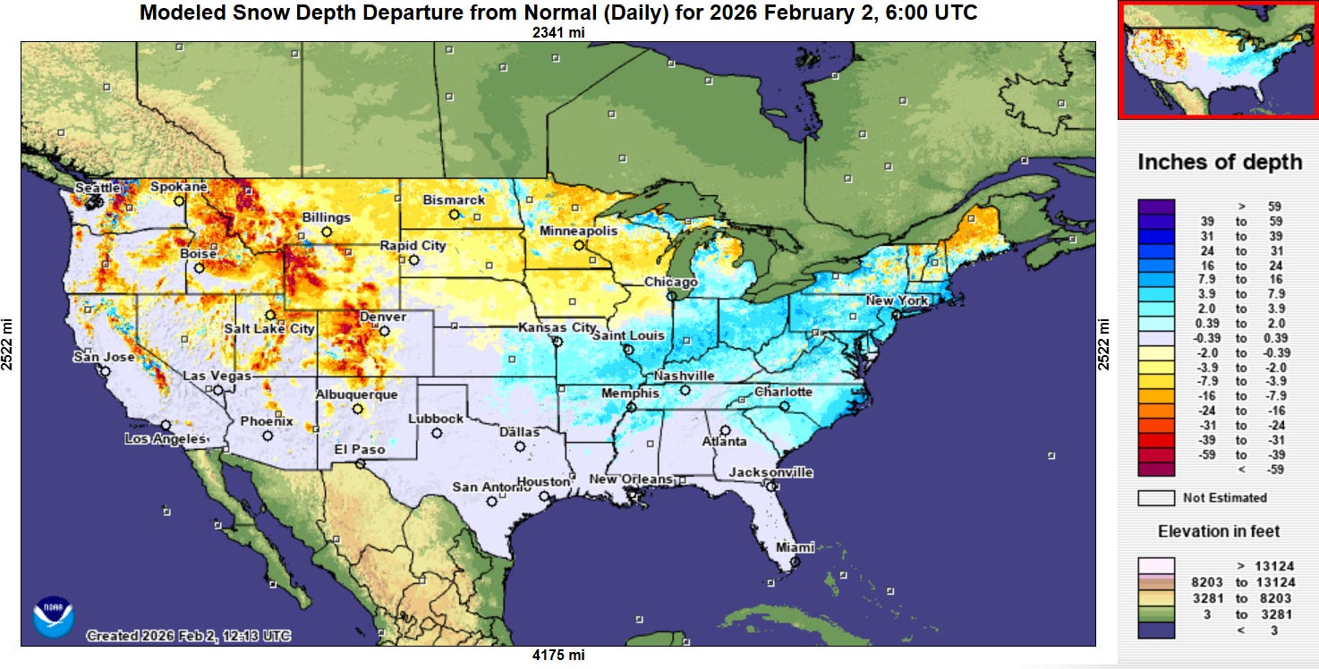
Obviously, the extreme cold and unusually heavy snow and ice accumulations that many parts of the country from Texas to the East Coast have suffered through over the last two weeks is unusual — particularly in the context of a trend toward milder winters in recent decades due to climate change. This map from the NOAA National Operational Hydrologic Remote Sensing Center (NOHRSC) shows that significantly above normal snow depth is in place for the region from the Mid-Mississippi Valley east. Newsweek reports that over the last two weeks the winter weather has caused nearly 90 deaths nationally, and while progress continues to be made, PowerOutage.us shows that nearly 80,000 customers remain without power in Mississippi, Tennessee and Louisiana more than a week after last weekend’s ice storm.
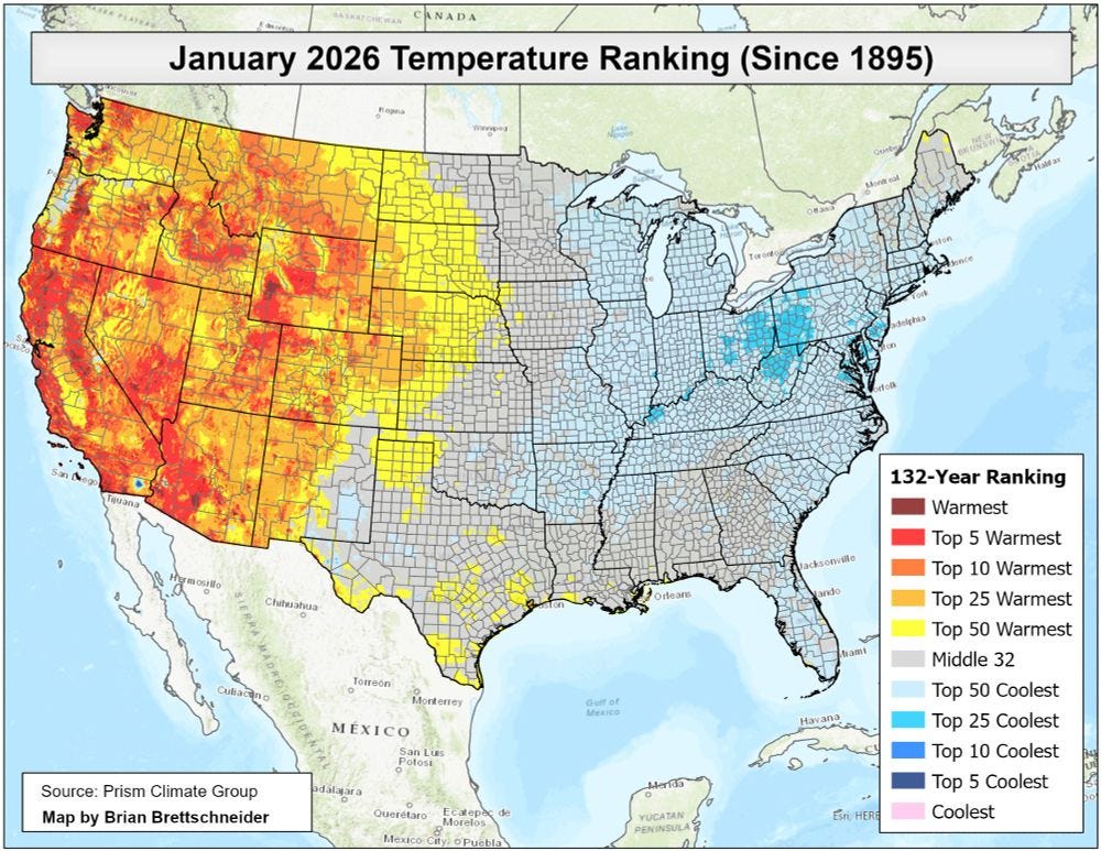
While the last two weeks was certainly one of the coldest, “wintriest” periods the Eastern US has experienced in decades, it is important to recognize that in the overall scheme of our climatic records back to the late 1800s, it was not that anomalous, i.e., the reason why it seems so unusual is because of the very trend toward warmer winters due to climate change. In fact, this analysis from climatologist Brian Bretschneider that even for the coldest parts of the East, this January was only about a top 25 coldest winter on record. Most of the West saw a much more unusually warm January — and in fact when you average the entire country out, Brian reports that January actually ended up a bit above normal as far as temperatures for the US (+0.8C compared to the 1991-2020 normal).
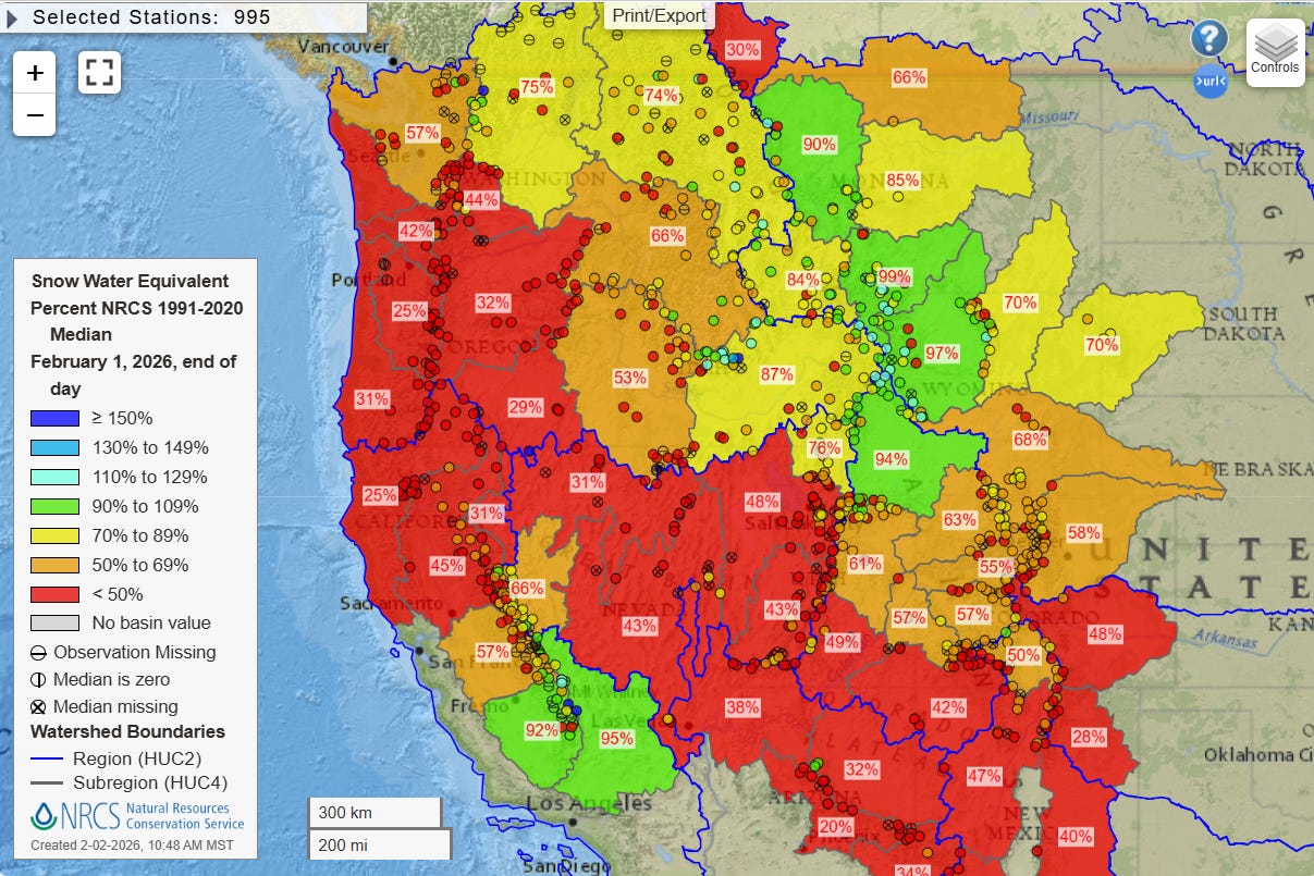
You can see in the NOHRSC map of snow depth compared to normal how much of the West and northern tier of the country are below normal. If we look at the USDA analysis of snow water equivalent for the West, we can see that much of the region is well below normal. The New York Times did an excellent analysis (gift link to article) over the weekend showing that the unusual warm and dry weather due to the persistent upper level ridge of high pressure over the West has caused “snow drought” conditions to reach record levels. One of the most startling statistics from the article: so far this winter, Salt Lake City has reported .1” of snow; the record lowest seasonal snowfall there is 14.3”.
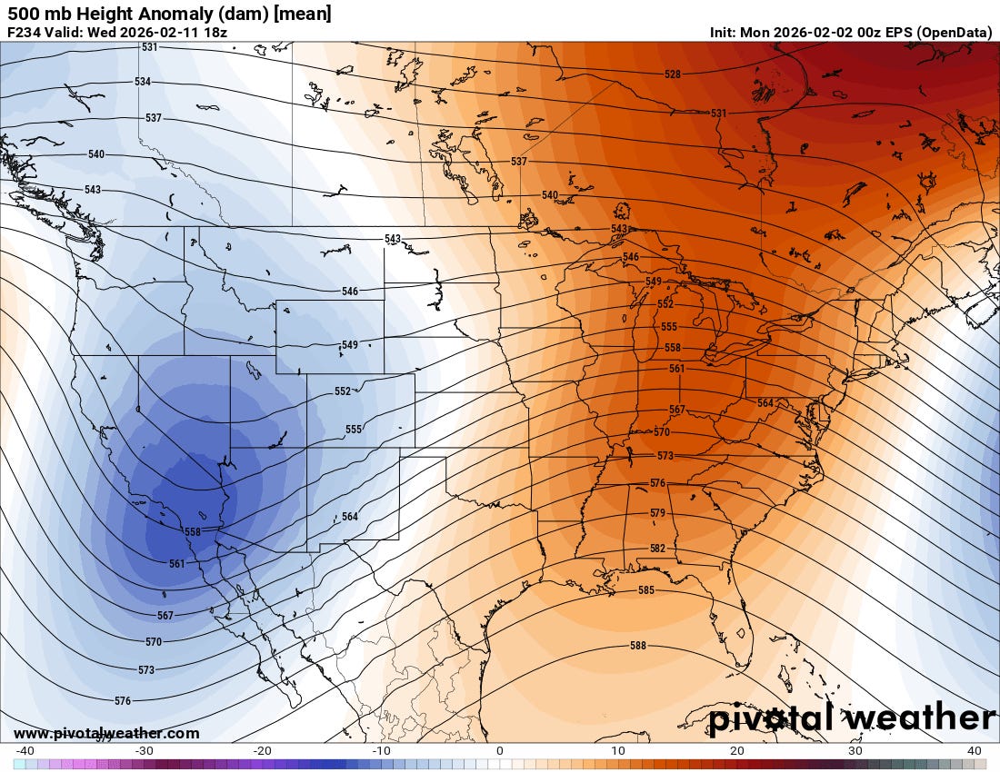
The NYT article reported on the increasing concern that water managers have about the dismal snowpack and potential serious impacts on the year’s water supply — but also correctly noted that obviously winter is not over and there is time to make up at least some of the deficit. In fact, the longer range ensemble models show a trend toward at least a temporary shift in the continental weather pattern next week toward an upper level trough over the western United States and downstream ridge of high pressure over the East. This should yield a cooler and at least somewhat wetter weather pattern the West next week.
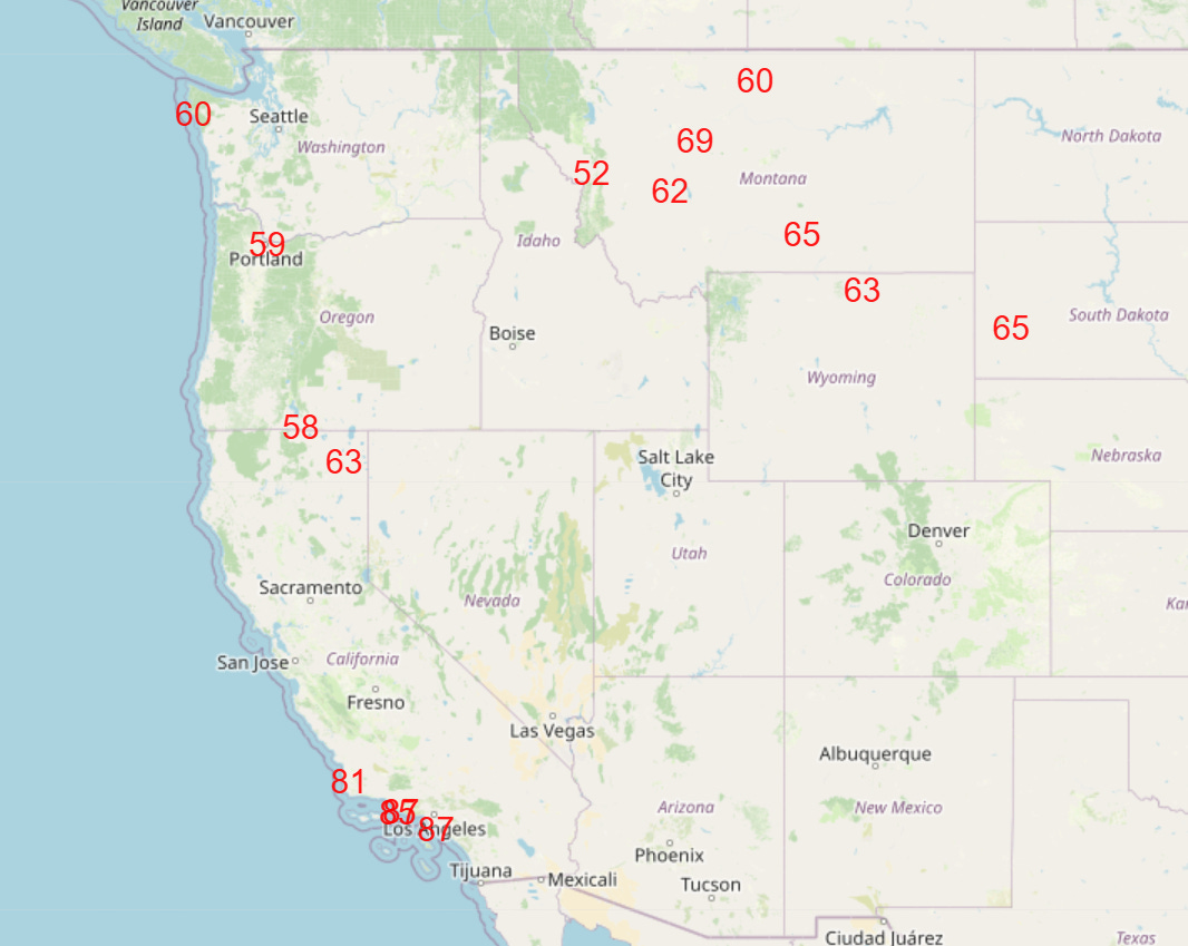
In the meantime, though, the warm and mainly dry weather will continue for most of the West. Phoenix set a record high temperature of 85F on Sunday (previous record 83F in 2003), and by this Thursday numerous record warm temperatures are anticipated across the West (forecast NWS record highs above).

In the East, the next upper level disturbance moving through the trough in the jet stream will bring some light to moderate precipitation to the region — but with warmer air surging north ahead of the system much of the precipitation will fall as rain. Some light to moderate snow is expected though in the Ohio Valley, Mid-Atlantic and Great Lakes.

Leave a comment