Sunday, March 16, 2025
We start off today looking at the final day of severe weather risks from the massive storm system that has been impacting the entire country from west to east the last several days. It’s finally the turn for the eastern part of the country to deal with this system.

The NWS Storm Prediction Center (SPC) now has an enhanced risk (level 3 of 5) for severe storms focused in western Pennsylvania and parts of western New York. This level of risk is being driven primarily by the risk for numerous incidences of straight line damaging wind from an anticipated line of severe thunderstorms that will move across the region during the early to mid afternoon hours. The morning high resolution model has a reasonable depiction of how the radar could look early this afternoon.
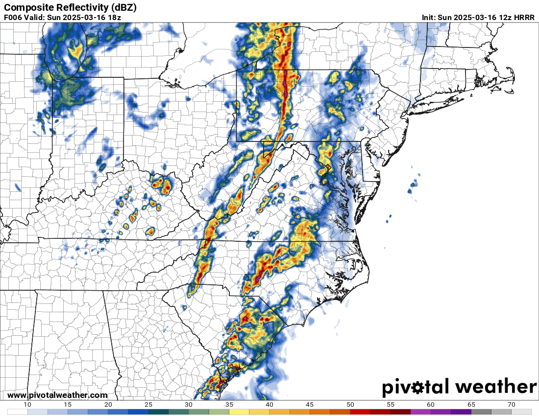
This line of storms will not consist of giant powerful severe storms like the ones seen in the Midwest and South the last couple of days, but the line of low topped storms will be energized by the core of the strongest winds in the atmosphere associated with the intense weather system sweeping through the area. Morning satellite data shows that at least some sunshine will break through ahead of this line adding some modest low level instability to the atmosphere to help the low topped storms “mix” strong wind gusts down to the surface. Additionally, intense wind shear in the lower levels of the atmosphere could support a few tornadoes within the band of storms.
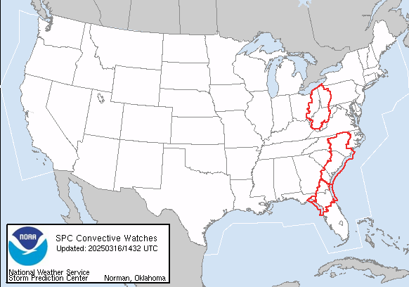
Farther south, the southern part of the large weather system will continue to support a broad area of relatively favorable conditions for severe storms. However, the instability in the atmosphere will be relatively limited and the stronger forcing from the upper level system is farther north in the area discussed above. There still will be bands of storms and the more intense storms could produce damaging winds and a few tornadoes, which is why there is slight risk (level 2 of 5) of severe weather over a large area from the Mid-Atlantic to northern Florida, and tornado watches from central North Carolina to northern Florida. A new tornado watch was also just issued for western Pennsylvania, eastern Ohio and West Virginia for the start of the northern severe weather event discussed above.
More Fire Weather Concerns for the Plains
Another strong weather system will be shifting across the country during the early to middle part of next week. While this system will not have the overall major weather impacts that this past one did due to more limited moisture return from the Gulf, it will still bring strong winds and drier air to the Plains region resulting in critical fire danger. SPC has already highlighted a large area from southern SD to the Rio Grande for elevated to critical fire danger for Monday as shown below as the weather system starts to develop and winds increase.

Additional fire weather concerns will exist over these same general areas Tuesday and Wednesday as winds increase and drier air overspreads the region as a strong low pressure system and cold front move east. This region saw a number of wildfires on Friday and conditions will remain favorable for additional fires as the weather conditions become favorable once again.
That summarizes the main weather worries for today. I will have some additional posts later today and Monday about the impacts of the last couple of days and thoughts about the forecasts.

Leave a comment