Tuesday, March 18th

Another strong low pressure system will be intensifying and moving into the central Plains the next 24 hours. While this system will be somewhat moisture starved in its warm sector, meaning it will have much less of a severe thunderstorm risk than the one last week, it will once again produce extreme fire danger in the southern Plains. SPC is highlighting southeast New Mexico, much of west Texas and western Oklahoma for extreme fire risk this afternoon and evening.
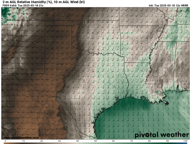
Very dry air will surge east this afternoon across this area on the south side of the low, with relative humidity values less than 10% expected. While winds will not be as strong this afternoon as what was seen last Friday, wind gusts of 40 to 50 mph are expected, which will promote extreme fire behavior combined with the very dry air and prime fuel conditions.
This dry air will be overspreading the region in the wake of an eastward moving dryline – a boundary between much drier air to the west and moist air to the east that is a common feature of the Southern Plains in the warm season. Forecasting the position of the dryline is key to forecasting both severe weather and fire weather – and is often challenging as the models can struggle with the feature. The dryline position is a key aspect of today’s fire weather forecast, as there is uncertainty as to how far east it will move and hence how far east into Oklahoma the extreme fire danger progresses. For now it is expected to remain to the west of the I-35 corridor, but that is something that we will be monitoring today. Regardless of the exact extent of extreme fire weather conditions today, the surrounding areas highlighted by SPC for critical and elevated fire danger will still be susceptible to wildfire issues due to gusty winds and overall dry conditions.
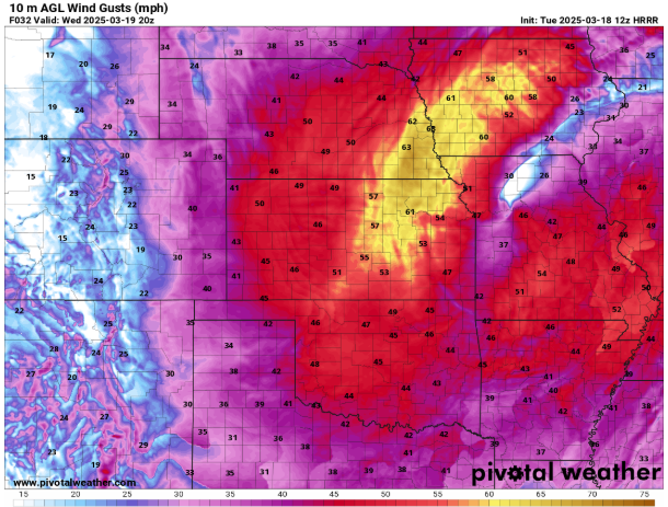
As the strong low pressure system moves into the Midwest Wednesday, strong winds will be an issue surrounding it, especially over parts of Iowa, Nebraska, Kansas and Missouri. Wind gusts of 50 to 60 mph will cause issues with travel and potentially downed trees/limbs. The low level airmass will be more moist, however, so fire danger will not be a big of a concern as it will be today. A band of heavy snowfall is expected Wednesday into Wednesday night on the north side of the low from eastern Nebraska to the upper Peninsula of Michigan (see below).


As I mentioned above, the severe thunderstorm potential with this storm system is much less than last weeks – but it’s not zero. SPC has outlooked a large area with a marginal (level 1 of 5) risk for severe storms on Wednesday. While conditions will not be particularly favorable for severe storms, there will be scattered thunderstorms associated with this system and a few reports of wind damage and hail are possible. There is a potential for a more organized and intense line of storms to develop along the cold front Wednesday afternoon; right now SPC is thinking that area will be in northern Illinois and western Indiana where they have a slight (level 2 of 5) risk of severe storms, primarily for damaging winds. There will likely be some evolution of this threat area as we get closer to the event Wednesday afternoon and evening, more later.
This system will be moving northeast with the accompanying cold front progressing east bringing showers and some storms to the eastern seaboard on Thursday. Right now the severe threat appears minimal, although we will keep an eye out on the Carolinas and eastern Virginia. Once the system moves east off the coast, relatively quieter conditions will be in store for the end of the work week for much of the nation.

Leave a comment