March 30

Let’s start off this morning with a quick recap of yesterday. Severe storms ended up developing somewhat south of initial expectations late Saturday, with a number of large hail and wind reports in northern Texas and southern Oklahoma. Eventually, as anticipated these storms organized into a band of storms that moved into Missouri and Arkansas, with several reports of wind damage and hail along the Missouri/ Kansas border, including a couple of significant wind reports near and west of Joplin.
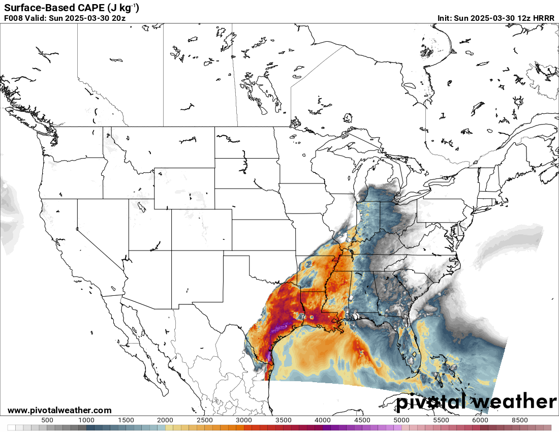
Those storms have weakened as they moved east, and overall things are relatively quiet this morning with a few clusters of storms in the mid-Mississippi valley and Texas. As the day goes on, a large swath of the middle part of the country from eastern Texas northeast into the southern Great Lakes region will become favorable for severe thunderstorms with rather high instability (shown above) and decent wind shear. This will set the stage for an active afternoon and night of severe weather.

The NWS Storm Prediction Center has outlooked most of this area in an enhanced (level 3 of 5) risk of severe weather for today. Probabilities for tornadoes, damaging winds and hail are all at the top end of the enhanced range, and hatched areas for potentially significant tornadoes and very large hail are also forecast. It seems likely that a focused area of higher end severe potential will likely end up with severe weather coverage at more of the level of a moderate (level 4 of 5) risk; however, today’s weather setup is a bit more typical of a late spring event in that it will be driven more by instability and smaller scale atmospheric evolution rather than an intense large scale system, so pinpointing that area of maximum risk is difficult.
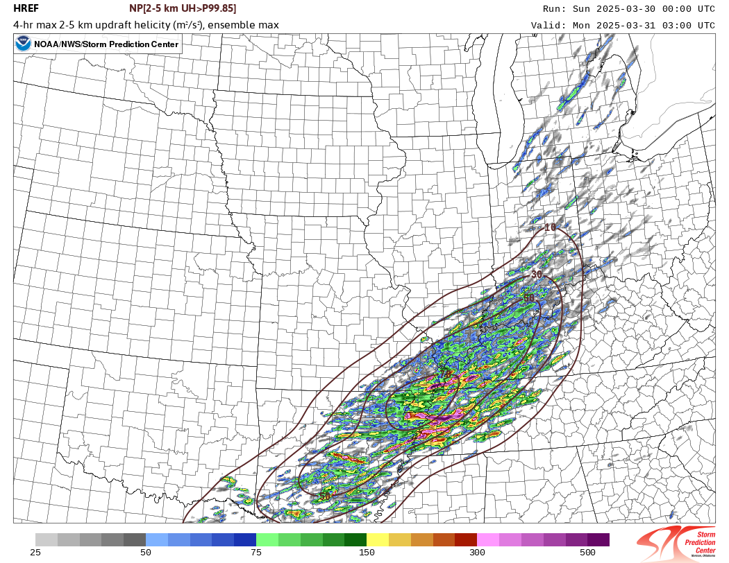
As we have been discussing the last couple of days, the area that seems the most likely for significant tornadoes is in the lower Ohio Valley to mid-South region. This area looks to have the best overlap of instability, low level wind shear, and more favorable storm mode later this afternoon and this evening for a greater tornado risk. The above graphic shows thunderstorm rotation from all of the members of the High Resolution Ensemble Forecast (HREF) system, and as you can see there are a number of tracks. To be clear, any one of these model forecasts for storm rotation is unlikely to verify; what we are trying to do with the HREF is run a number of model scenarios to try to ascertain the areas more likely to have rotating supercell thunderstorms, and the number of tracks the HREF shows in the region helps us focus on this area for a greater risk.
As we go through the night, the storms are likely to organize into more of clusters and bands as they move into the Tennessee Valley and Lower Mississippi Valley, with an increasing risk for wind damage along with continued potential for tornadoes and large hail.
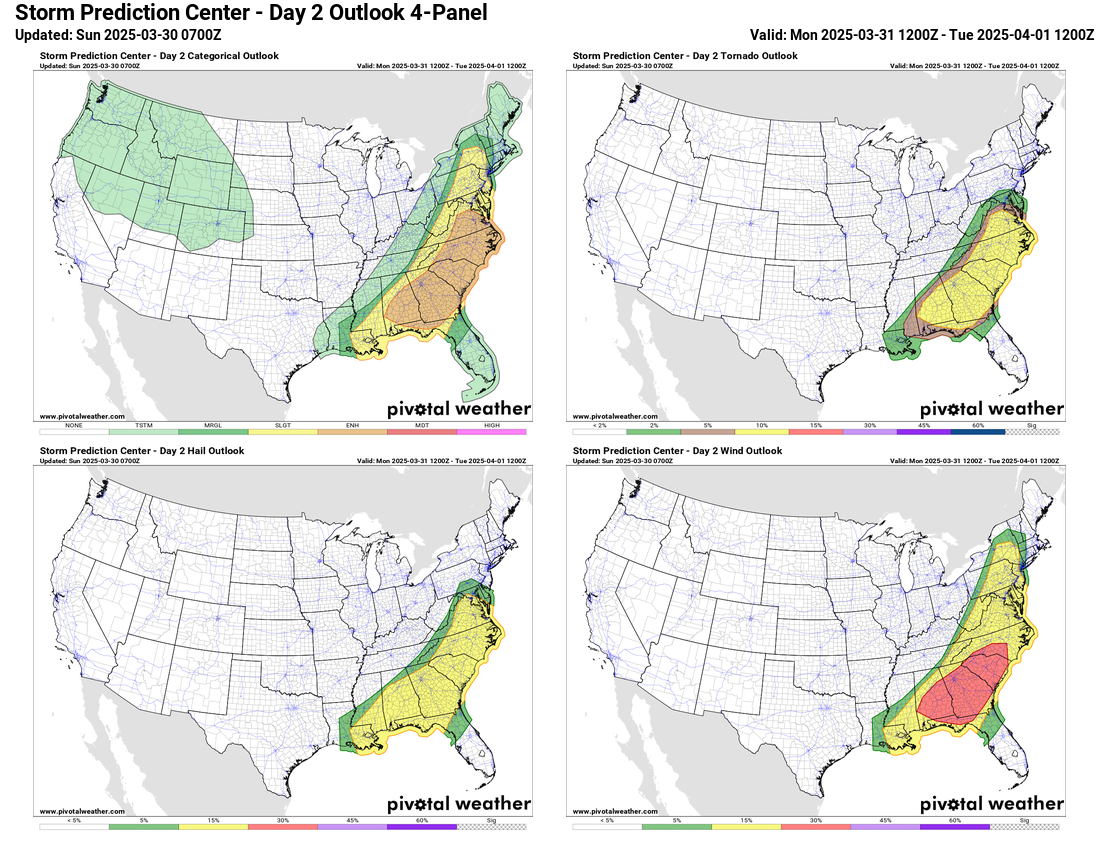
Strong to severe storms will likely be ongoing first thing Monday in parts of the lower Mississippi Valley and Southeast, and a continued risk of severe weather will exist through the day. SPC has outlooked an enhanced (level 3 of 5) risk for Monday as well from the mid-Atlantic to the eastern Gulf Coast. However, if you look at the probabilities for each of the three hazards you will see they are not as high on Monday as today, and there are no hatched areas outlooked. So while there is certainly a continued risk for severe storms with large hail, damaging winds and tornadoes, the risk on Monday is a bit less than what is anticipated today.
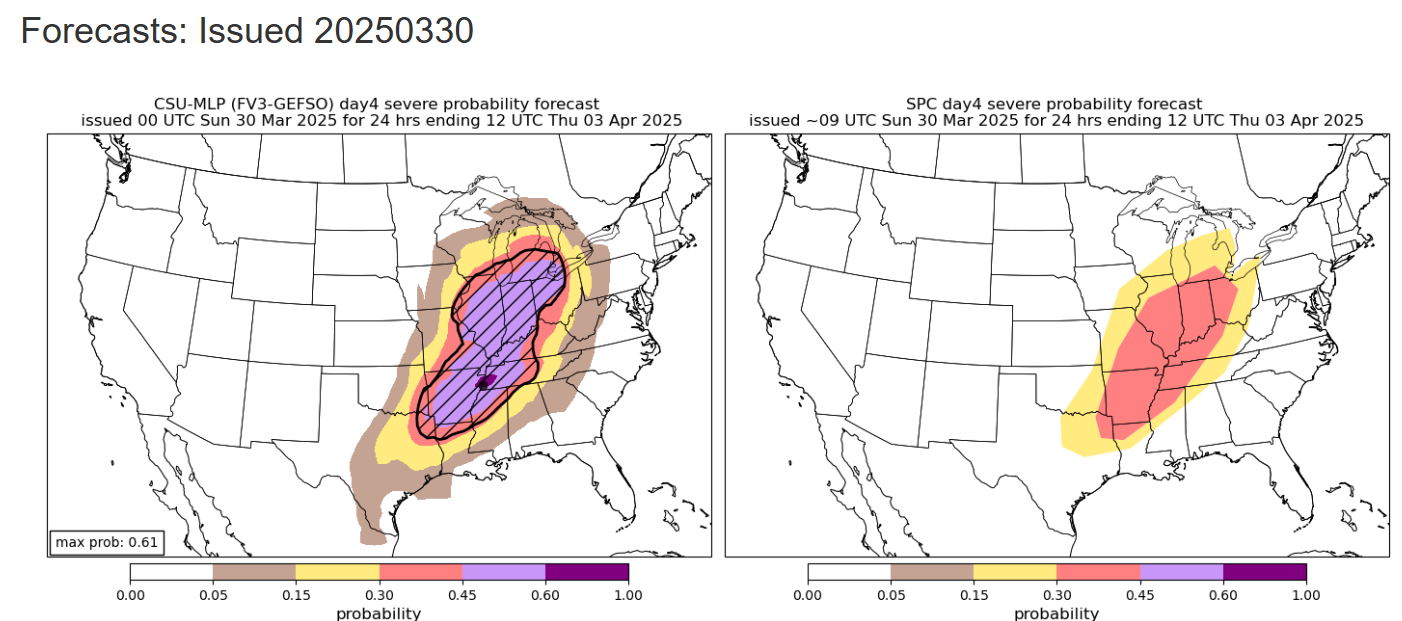
Once today’s system exits stage right by Tuesday, attention will rapidly turn to the next system which looks to have the potential to produce a high end day of severe weather on Wednesday. As you can see in the left side graphic above, the Colorado State University machine learning system has a large area of 45% severe weather probability forecast from the lower Great Lakes to the Arklatex, with the area hatched indicating the potential for significant severe weather (very large hail, damaging winds greater than 75 mph, and/or EF2+ tornadoes). SPC has a corresponding 30% area forecast, which is as high as they can forecast at this time range. SPC headlined their narrative discussion for Wednesday with the statement that a severe weather outbreak is possible Wednesday, which shows the concern they have for this setup.
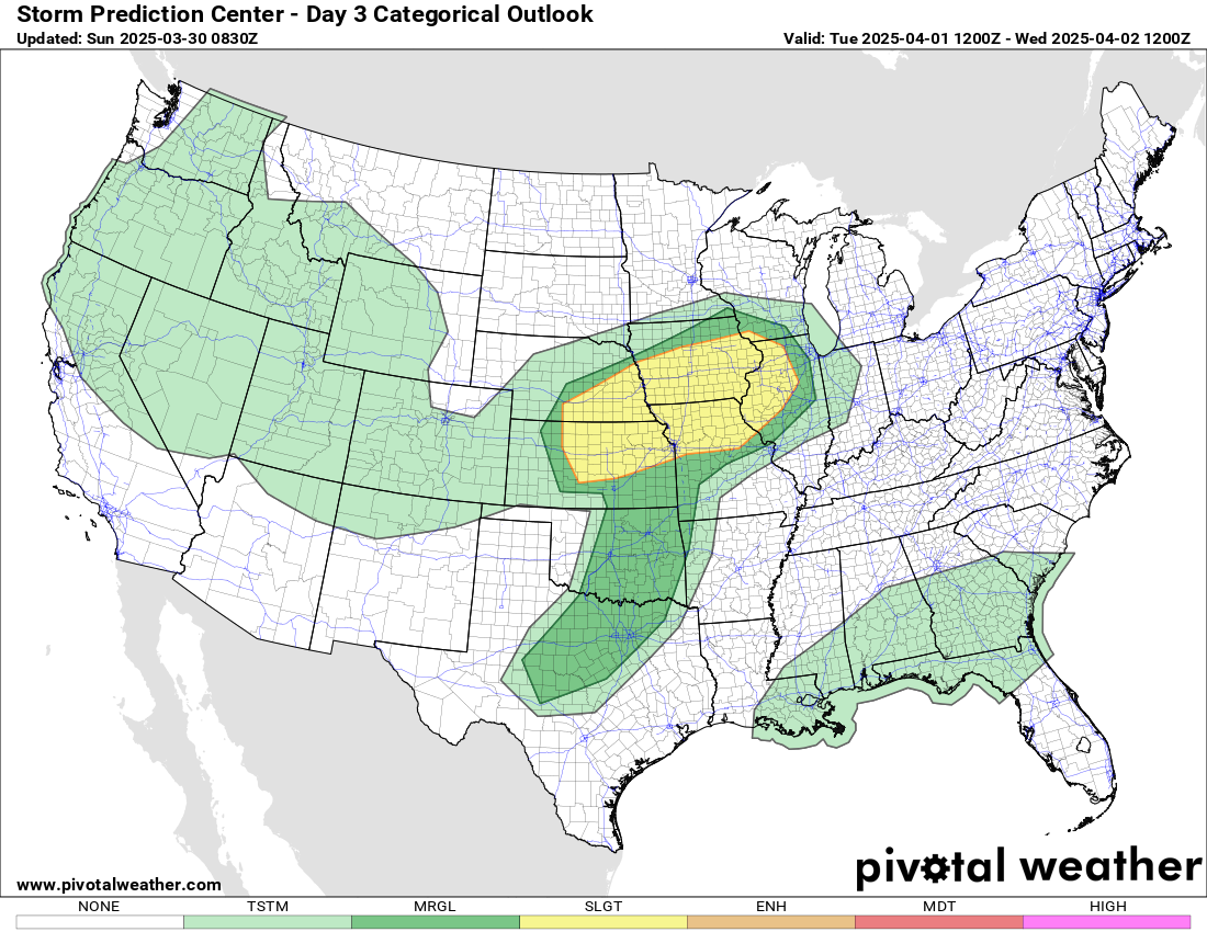
The risk of severe storms with this system will begin on Tuesday afternoon/evening with SPC forecasting a slight (level 2 of 5) risk of severe storms as shown here. Obviously, we need to get through the near term event of the next 24 to 36 hours, but we will be looking at the event very closely in the coming days. The pattern looks to remain active into the end of the week as well with additional severe weather threats, but the Wednesday system looks like the one with the highest potential over a large area.
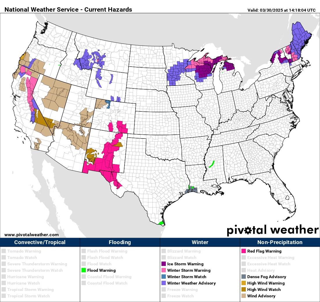
As we discussed yesterday, in addition to the all of the severe weather risks, there will also be fire weather risks on the southwest side of these systems and winter weather risks on the northern side of these systems. The fire weather risks look to be concentrated in New Mexico and western Texas, where elevated to critical to fire weather conditions are forecast the next few days and Red Flag Warnings are in effect. Wintry precipitation is forecast today across the northern Great Lakes into northern New England. Freezing rain will be a particular concern and Ice Storm Warnings are in effect in parts of this area. The system that will be the midweek severe weather concern will be coming into the western United States over the next 24 hours, and wind warnings/advisories and winter headlines for mountain snows are in effect there.
Programming note: I will be out of pocket much of the day today, but hope to post some updates via Substack Notes and Facebook/BlueSky this evening. For the Wednesday severe weather threat, I am planning some video briefings and real-time Substack chats; as I continue to better learn Substack and the subscriber base continues to grow, the briefings and chats will become paid subscriber benefits as outlined here.

Leave a comment