April 1
Good morning and happy start of April! The older I get the more I find April Fool’s Day jokes to just be annoying, plus there’s so much happening on the weather front we don’t really have time to talk about it all, so let’s just get to it.

A quick recap of yesterday: the line of severe storms we discussed in yesterday’s newsletter moved across the Southeast and produced a number of wind damage reports as anticipated, along with a couple of tornadoes and a handful of reports of large hail. Additional strong to severe storms did develop farther north in the mid-Atlantic and produced some strong winds, including a measured 58 mph wind gust at an NWS observing site in northeast Philadelphia.
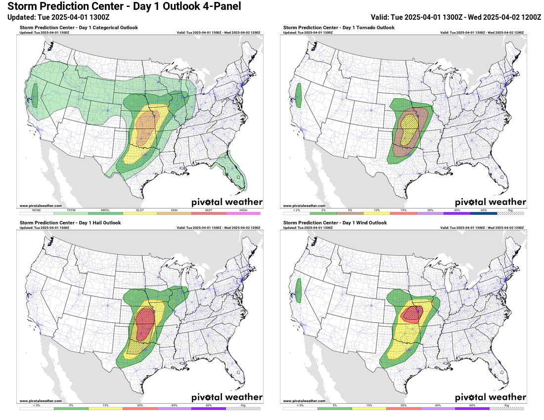
The active period of severe weather continues today, and things have trended more concerning as far as potential in the Plains region. As the big weather system that we have now been talking about for several days starts to pull out across the southern Rockies late today, it will encounter moisture streaming rapidly north out of the Gulf. This will result in a rather volatile atmosphere supportive of high end severe storms; the main question will be where and how many storms will develop given that a “cap” of warmer air will also exist in middle levels of the atmosphere.
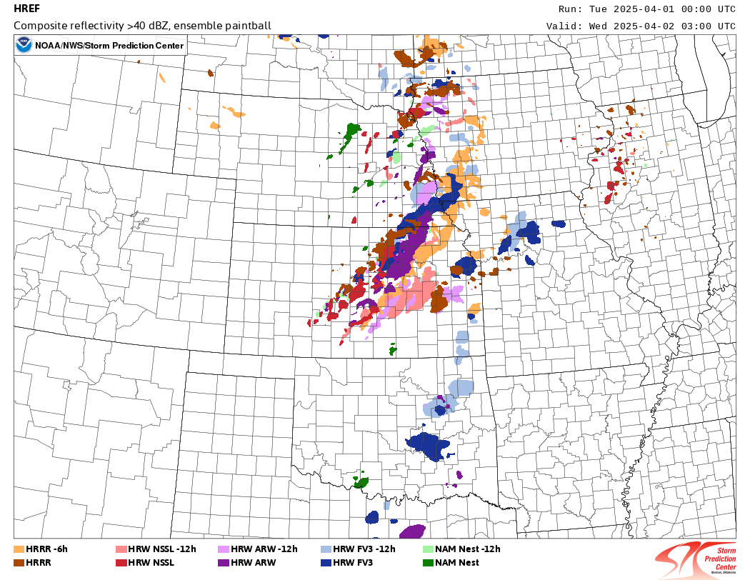
This graphic shows where each of the models that makes up the High Resolution Ensemble Forecast (HREF) system has storm development this evening. As you can see, most of the models have storms breaking out over Kansas, and that is where SPC accordingly has the highest risk, an enhanced (level 3 of 5) forecast. Farther south across Oklahoma and northern Texas, the development of storms becomes less certain, but the environment in this entire area will be very favorable for intense severe storms capable of producing very large hail with significant tornadoes particularly supported with any storms in Oklahoma and Kansas. With time, the storms are expected to evolve into a complex or line of storms overnight with an increasing risk for damaging winds, especially over Kansas and into western Missouri.
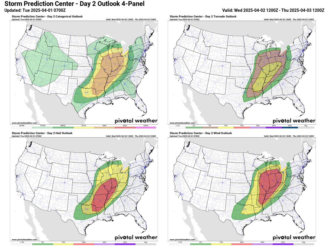
The upper level system responsible for today’s severe weather risk is still expected to intensify further as it lifts into the upper Midwest on Wednesday. As moisture continues to flow north from the Gulf a large area from the Arklatex to the southern Great Lakes will have a volatile combination of very unstable air and increasing wind shear in the atmosphere to support intense severe storms capable of all forms of significant severe weather hazards: 2+” hail, EF2+ tornadoes and wind gusts greater than 75 mph. This is shown by the hatched areas in all three of the individual hazard outlooks in the SPC day 2 outlook above. This equates to an enhanced (level 3 of 5) risk of severe weather over this entire region as shown in the upper left panel.

As I talked about with the system last weekend, as we get later into the spring and the amount of moisture and instability in the atmosphere increases, the timing and magnitude of severe weather risk becomes more sensitive to how storms develop on the smaller scale and less about the position and timing of the larger scale features in the atmosphere. Wednesday’s event will be an example of this. While the large scale weather system driving the severe weather outbreak is very intense, it is lifting somewhat north of the large area of instability and moisture. So even though it is creating a large swath of atmosphere very favorable for severe storms and tornadoes as shown by the HREF mean significant tornado parameter above – values of greater than 4 potentially support significant tornadoes over a large area – the forcing for storm development in that area will be more forced by remnant storms and boundaries from today’s activity and more subtle disturbances. Hence, narrowing down the timing and maximum risk within the large enhanced risk area is challenging; but given the environment, it seems likely that some areas will verify with at least moderate (level 4 of 5) risk levels of severe weather.

This weather system will lift farther northeast and weaken Thursday, but it will leave behind a strong trough of low pressure in mid and upper levels of the atmosphere over the Southwest US. This will enable the cold front associated with the main system to stall out and become the focus for numerous rounds of severe storms across the Ohio Valley, mid-South and Arklatex region for the rest of the week as shown in the Colorado State University machine learning probabilistic severe weather forecast. While not as favorable over an expansive area as the next couple of days, conditions will still be supportive of higher end severe storms, and as the atmospheric forcing comes more into focus we will likely be highlighting areas for higher risks of severe weather including potentially significant tornadoes.
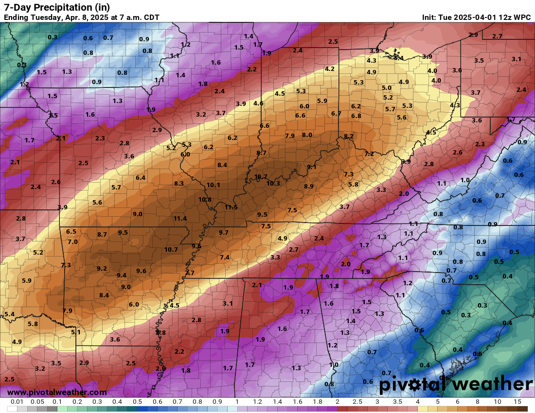
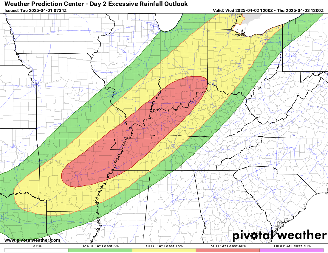
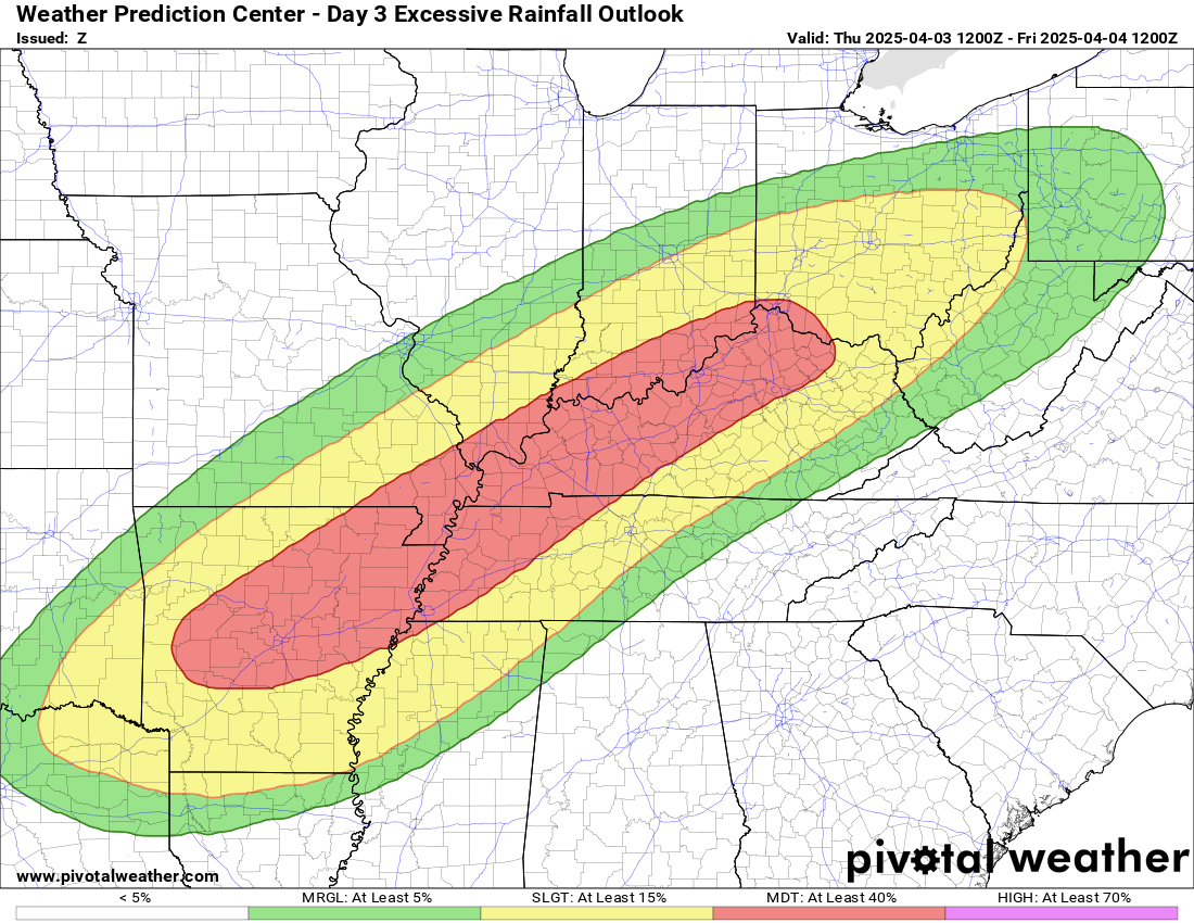


As if all of this severe thunderstorm activity was not enough, this weather pattern is going to support a major heavy rainfall and flooding event across the central part of the country. Several days of intense thunderstorms fueled by unusually high moisture will result in a large swath of rainfall totaling 6 to 12”. The Weather Prediction Center is responsible for flash flood probabilistic outlooks, and they have moderate (level 3 of 4) risks out for four consecutive days as shown above; southeast Missouri is in the moderate risk all four days! Needless to say, flooding is likely to be as big of a story as the severe weather this week; if you want to read a great in-depth discussion of this heavy rainfall setup, I highly recommend this article from yesterday by my friend and colleague Matt Lanza at The Eyewall.
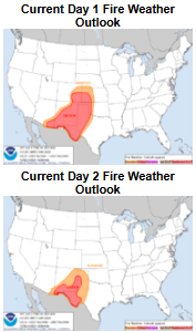
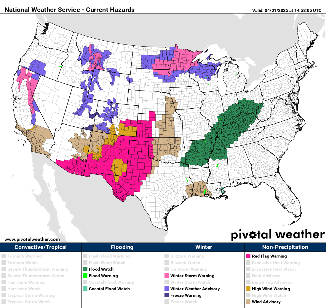
On the southwest side of all of this action, strong winds and dry conditions will result in critical fire danger today and Wednesday, and Red Flag Warnings are in effect for a large area. On the cold side of the system, heavy snows can be expected in the Intermountain West today and heavy snow and potentially freezing rain will develop in the upper Midwest where winter storm warnings and winter weather advisories are in effect.
Again, after this weekend, a major weather pattern shift is anticipated, with an upper level ridge developing over the West and a corresponding trough along the East Coast. This will shutdown this active severe weather/flood pattern for at least several days.
Programming note: Given the very busy weather this week, I am planning to provide periodic updates via special posts, video briefings, Notes and real-time Substack chats starting today. As I continue to better learn Substack and the subscriber base continues to grow (over 200 now, thanks!), the briefings and chats will become paid subscriber benefits as outlined here.

Leave a comment