Very busy evening will continue through the overnight
We’re still in the fog of war this evening as an ongoing outbreak of severe weather continues. But given that we are anticipating severe weather to continue overnight – and in some areas to ramp up in the predawn hours – I wanted to throw out a quick email update.

Severe weather is still ongoing and reports are coming in fast and furious, but it has been a very busy day, and as expected there have been multiple significant incidences of all three severe convective hazards, namely large hail, damaging straight line winds, and tornadoes. There have been about 20 reports of hail at or larger than 2” in diameter, with most of these in southern Missouri, eastern Arkansas, western Tennessee and extreme northern Mississippi. Several reports of baseball sized hail occurred. Meanwhile, a series of strong straight line wind producing bow echoes moved across Illinois, Indiana, southeast Missouri and western Kentucky this evening producing widespread wind damage including in the Indianapolis area. Nearly 150,000 customers are without power in Indiana, and multiple locations reported wind gusts greater than 75 mph.
Finally, a number of tornadoes occurred this afternoon and evening, the most significant of which were associated with a rash of supercells that developed in eastern Arkansas ahead of the main band of severe storms. The most intense tornado was almost certainly the one that impacted regions near Lake City and Monette, AR between about 6:30 and 7 pm CT.
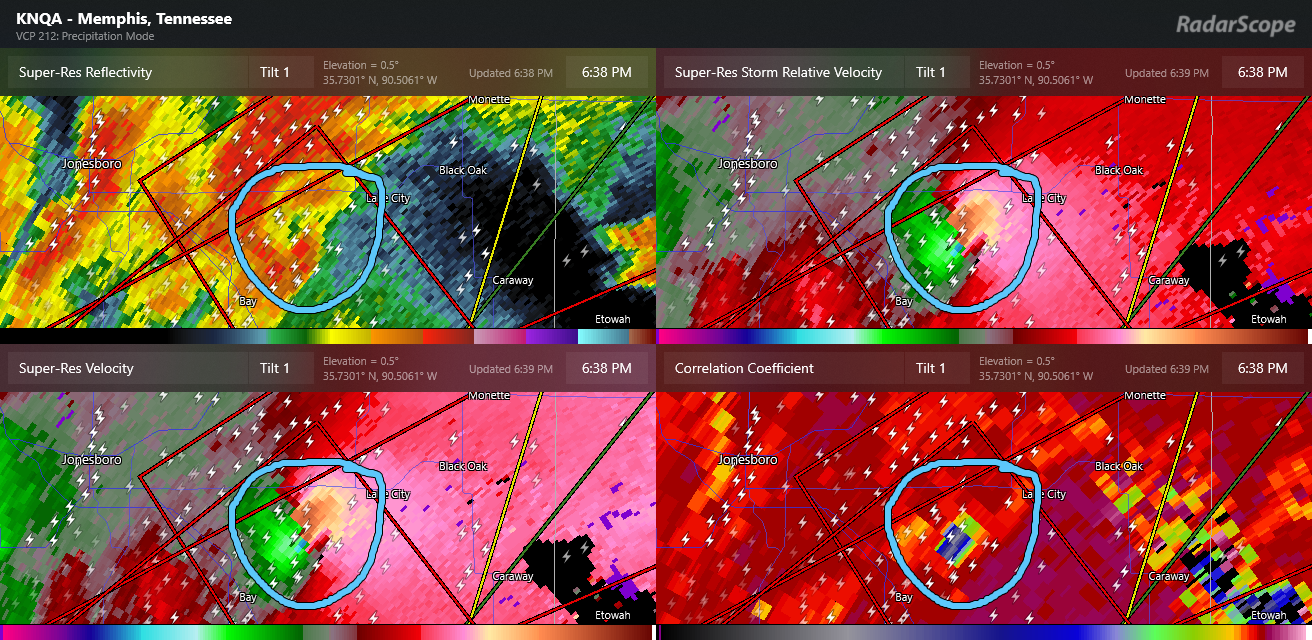
This tornado likely had a path length of at least 25 miles and based on video and radar data was quite likely an EF3 or greater tornado. Debris was lofted to at least 25 Kft and detected by radar. Other damaging tornadoes occurred near Potosi and Cape Girardeau in Missouri, and several embedded tornadoes likely occurred within the line of storms that moved across Illinois and Indiana.

Where we stand now is that most of the storms have congealed into a single long band of strong to severe storms extending from southeast Lower Michigan to southern Arkansas. These storms will remain intense for the next several hours, capable of producing significant straight line wind damage along with embedded tornadoes. A few areas to highlight for particular risk…
The bow echo that caused extensive wind damage in the Indianapolis area will continue into parts of western and central Ohio with a continued threat for widespread damaging winds and embedded tornadoes
The convective system running from southwest Indiana to near Memphis will continue east with a risks for straight line winds and potentially a few embedded strong tornadoes
Along the southwest flank of the system, some supercell storms will remain possible in southern Arkansas with a risk of large hail and possibly a couple of tornadoes
Later tonight, the band of storms will begin to slow and eventually stall out from West Virginia back into Arkansas and northeast Texas. A new upper level impulse of energy should begin to move into northern Texas in the pre-dawn hours and cause an intensification of severe storms in this region, including potentially the Dallas-Fort Worth Metroplex region. Very large hail, damaging straight line winds, and a few tornadoes could occur with these storms into early morning hours Thursday. This impulse is expected to produce additional severe storms across Arkansas and into western Tennessee and far northern Mississippi Thursday afternoon and evening, and an enhanced risk – level 3 of 5 – is in effect for this region for anticipated supercell storms that could produce very large hail and potentially a few strong tornadoes.

The threat of flash flooding will really start ramping up Thursday as well, as waves of storms begin to move across areas impacted by heavy rainfall today and tonight. The Weather Prediction Center has a high risk of flash flooding outlooked for Thursday in the mid-South region, and as we have discussed this is unfortunately just the start of a several day excessive rainfall event which the NWS is indicating could produce historic rainfall totals with potentially catastrophic flood and flash flood impacts. We will obviously be going into more detail about this in tomorrow morning’s newsletter.

Leave a comment