NWS calling for “generational” flooding impacts today
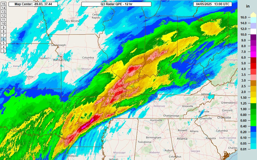
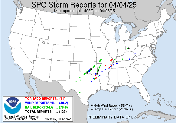
The weather stayed active overnight. The band of strong to severe thunderstorms we were monitoring last evening stayed active through the overnight, producing several tornadoes in northeast Arkansas and western Tennessee. The more widespread impact was torrential rainfall causing significant flash flooding. MRMS radar estimates of 4-6” of rain overnight in the Little Rock metro as well as western parts of the Memphis metro area, while widespread 3-5” fell from central Indiana southwest across southern Illinois and southeast Missouri. Many, many reports of flash flood impacts were received from these areas.
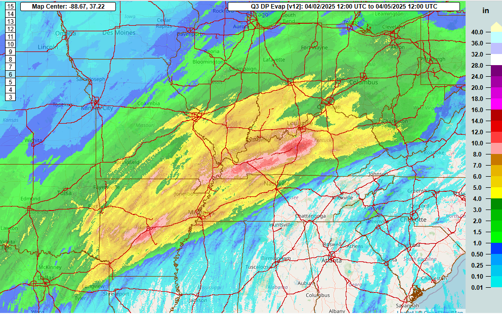
Of course, this was day 3 of this multiday severe weather and flash flood event, and rainfall totals continue to add up. Nearly all of the area from Arkansas up through the Ohio Valley has seen more than 4” of rain in the last 3 days, and much of Kentucky has now seen more than 8” of rain. While today will finally be the last day in this event, unfortunately for some areas in the Mid-South today will likely be the day of heaviest rain, with much of the entire region seeing additional heavy rainfall. This rain on top of already saturated, flooded conditions will yield flooding that the National Weather Service has warned could be “generational.”
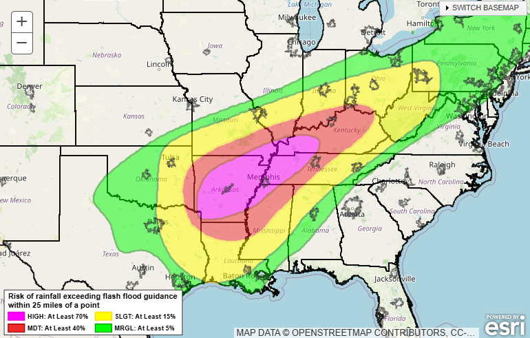
The latest Weather Prediction Center excessive rainfall outlook has outlooked a large high risk (level 4 of 4) for flash flooding through tonight. Morning high resolution models suggest multiple rounds of thunderstorms moving over this region today, bringing several inches of additional rainfall. The Little Rock upper air sounding this morning had a precipitable water value of 1.62”, which is above the running median max value for this date in the SPC sounding climatology; this means that rainfall rates will be particularly high. With antecedent conditions already saturated or flooded, these rains will runoff immediately, causing serious flash flooding and eventually major river flooding.
The area that looks the absolute greatest at risk today looks to be western Tennessee, eastern Arkansas and northern Mississippi which looks to be the region that will have training of storms for the longest period of time. Much of Kentucky – both the high and moderate risk areas – are also serious concerns given the huge amounts of rain that have already fallen and terrain that is particularly vulnerable to flash flooding. Anyone under the WPC risk areas should be alert to flooding issues today and be sure to avoid driving through flooded areas. In fact, the NWS Little Rock office has specifically advised people to stay off the roads if at all possible today due to the already ongoing serious flooding which is expected to worsen today.
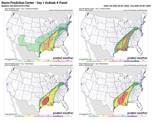
Severe thunderstorms remain an additional risk today, with the Storm Prediction Center outlooking much of the Mid-South and Lower Mississippi Valley with an enhanced (level 3 of 5) risk of severe storms today. A line of severe storms is starting to evolve in the Arklatex region late this morning, and is expected to eventually make it’s way east across the region this afternoon and evening. In addition, supercell thunderstorms will likely develop ahead of the line especially across parts of northwest Mississippi and western Tennessee. All of these storms will have the potential to produce large hail, damaging winds and tornadoes, a few of which could be significant.
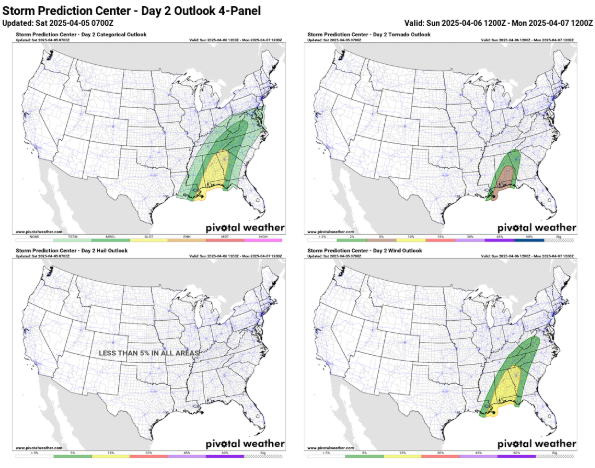
Finally, later tonight into Sunday the stuck weather pattern of the last week will begin to dramatically change. As a strong upper level trough of low pressure begins to develop over the Northeast US, it will pull the upper level weather system we’ve been discussing into the Southeast and force it to weaken. It will produce one more day of severe weather risk in the Southeast on Sunday, but the risk of storms should be less than we have seen with a slight (level 2 of 5) risk currently outlooked. Still, though, a band of severe storms with damaging winds and a few tornadoes looks probable in the region Sunday before the system gets completely absorbed into the new trough developing in the Northeast.
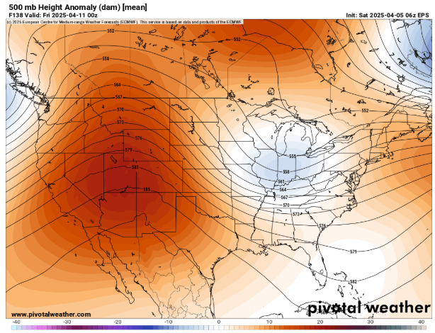
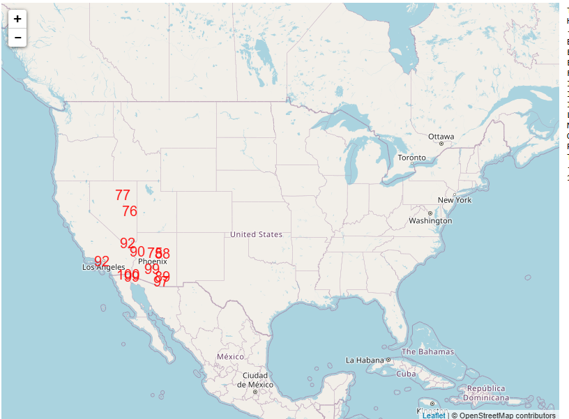
By the middle and latter part of next week, the weather pattern over the United States will become dominated by an unseasonably strong ridge of high pressure in middle and upper levels of the atmosphere over the western half of the country. Record heat is probable in parts of the region by late in the week – below are forecast high temperatures near or above records on Thursday.
As flood and severe weather conditions evolve today, I am planning to continue to provide additional details and updates today via special posts, Notes, live and recorded video briefings and real-time Substack chats. As I continue to better learn Substack and the subscriber base continues to grow (250+ free subscribers now, thanks!), the videos and chats will become paid subscriber benefits soon as outlined here.

Leave a comment