Flash flooding becoming serious in parts of the Mississippi and Ohio Valley regions

This will be a fairly quick update before we get into the overnight period. The rainfall has continued to add up across the middle of the country, with parts of Kentucky now having 3 day totals greater than 12” based on MRMS multi-sensor estimates.
A loop of MRMS rainfall rate estimates shows that the storms have organized into a band from southern Indiana back into the Arklatex. The storms have been slowly moving east and periodically stalling out for times, causing very heavy rainfall and significant flash flooding all along the band.
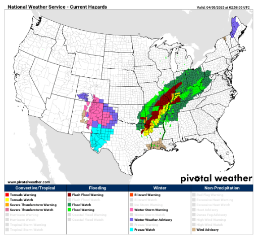
Flash flood emergencies are in effect now for a couple of southeast Missouri counties, and numerous flash flood warnings for significant flash flooding are in effect across the entire region.

This band of storms will eventually completely stall out sometime Saturday morning, and new storms will develop along the southwest portion in the Arkansas/Louisiana region and start lifting north as shown in this evening high resolution HRRR model radar forecast for midday Saturday. Where the storms stall and how new ones form will play a big role in where the absolute heaviest rain falls, but there along will be a period from late tonight through Saturday evening that will see the absolute heaviest rainfall of this multi-day event. The evening high resolution models still suggest that this will be in Arkansas into parts of Kentucky and Tennessee, but more recent models also suggest that more of northern Mississippi could be impacted by this extremely heavy rainfall as well. Overall the latest trends still support the day 2 excessive rainfall outlook shown below.

While there have been several supercells today that produced some several tornadoes in northeast Texas and also north central Arkansas and southeast Missouri, the severe weather has been somewhat less today than in previous days. There will continue to be a risk of severe storms with the line of storms as it moves east tonight, with damaging winds and embedded tornadoes the primary risks.

As the storms expand and reintensify as described above on Saturday, there should be an increase again in the risk of severe storms. SPC continues to have an enhanced risk (level 3 of 5) for severe storms with the potential for significant incidences of tornadoes, hail and/or wind with the most intense storms.
More updates in the morning, have a good and safe night.

Leave a comment