Severe weather and eventually heavy rainfall also potential issues for central US
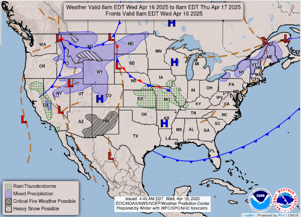
Running a little late this morning (sorry), so will make this morning’s newsletter focused on the weather concerns of the next several days. Let’s start off by taking a look at today’s forecast weather map. A new storm system is beginning to take shape in the northern Rockies. Heavy late season snow is expected in Montana where winter storm warnings and winter weather advisories are in effect. Farther south, scattered thunderstorms are expected to develop later today and tonight across parts of the central and southern Plains.
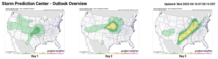
A few severe storms with large hail and gusty winds are possible from the Texas Panhandle to the mid-Missouri Valley, and SPC has outlooked a marginal (level 1 of 5) risk for this region. This storm system is expected to bring a somewhat greater risk of severe storms Thursday and Friday as can be seen in the day 2 and 3 outlooks. As of now, SPC just has a slight risk (level 2 of 5) outlooked for both days. On Thursday, some of the storms look to have the potential to produce very large hail, but the tornado risk looks fairly low. Friday sees the slight risk expand along a broad area as a few severe storms will be possible along a southeast moving cold front, but as of now there does not appear to be a focused area of higher severe potential.
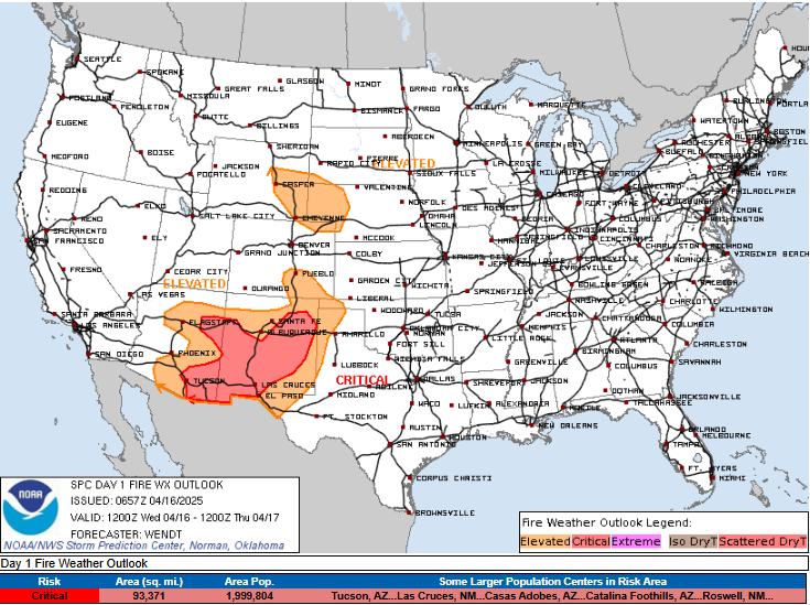
Of greater concern on the southwest, dry side of this weather system is the fire weather situation, which has trended more ominously with recent forecasts. As the storm system over the northern Rockies intensifies and starts to move into the central United States, west to southwest winds will increase to the south of it across the southern Rockies and Plains and bring increasingly drier air into the region. This will increase fire danger starting today across New Mexico and eastern Arizona, regions which are dealing with severe drought in many areas.
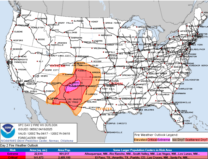
By Thursday, conditions will trend more dangerous as the storm system further intensifies and strong winds at low and mid levels of the atmosphere overspread a larger region. By mid to late afternoon, the area from western Kansas across New Mexico and into western Texas is anticipated to see single digit value relative humidity and winds gusting over 40 mph, resulting in a large area of critical fire danger.
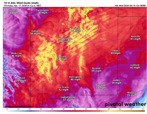
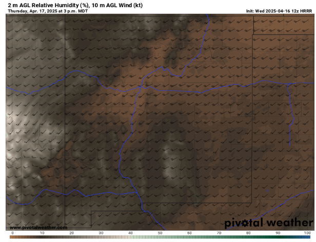
Of particular concern is central into northeastern New Mexico, where high resolution models suggest the potential for several hours with wind gusts greater than 50 mph along with particularly low relative humidity values around 5%. SPC has outlooked this region for extremely critical fire danger with the potential for a significant fire weather event with extreme fire behavior should any wildfire ignitions occur.
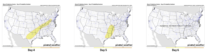
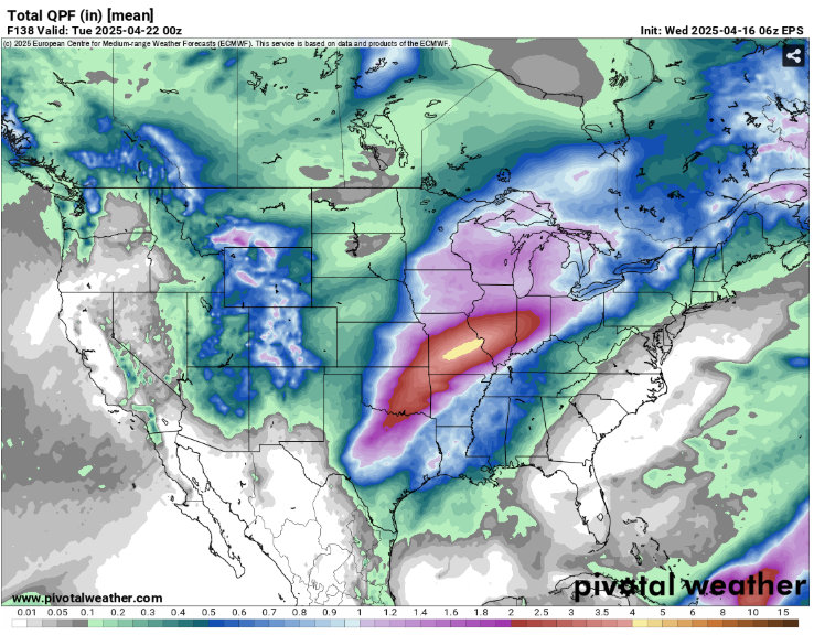
The storm system discussed above will continue to track east this weekend and weaken as a new storm system takes shape over the southwestern United States. There is still a lot of uncertainty in the details as far as the strength, timing and speed of this system. Having said that, there is confidence that the overall weather pattern will support several rounds of thunderstorms over a large area from Texas through the Ohio Valley this weekend. Some of these storms could be severe as seen in the SPC outlooks. As we discussed yesterday, heavy rainfall could prolong or exacerbate flooding issues in parts of the mid-Mississippi and lower Ohio Valleys. Again, forecast model spread is higher than usual with this system, so anticipate refinements to the forecast as we get closer to the weekend.

Leave a comment