And watching for a significant severe weather episode in the upper Midwest Monday
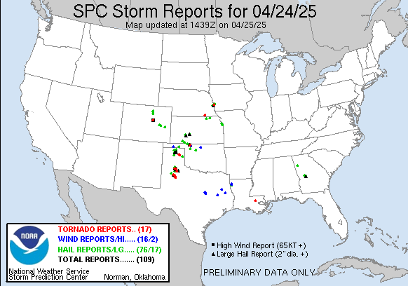
Happy Friday! Yesterday afternoon and evening ended up being quite active from northwest Texas and the Panhandle across northern Oklahoma into southwest Kansas. Several intense supercell storms produced a number of tornadoes along with multiple reports of hail larger than baseball sized. The largest hail reported was just over 5” – larger than softball sized – in Floyd County, TX. Other severe storms were scattered around northeast Colorado, northeast Texas, northeast Kansas and southwest Nebraska.
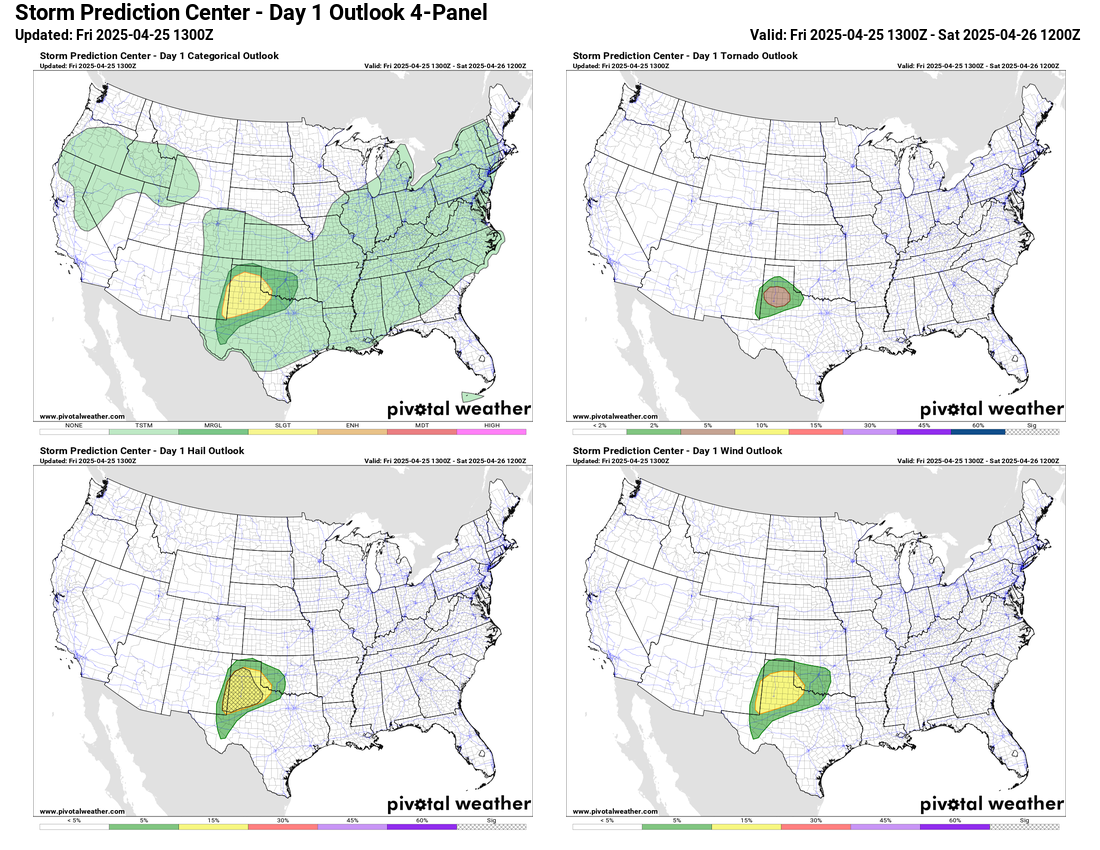
The severe weather threat for today looks as if it will be more focused across northwest Texas, where the Storm Prediction Center has a slight (level 2 of 5) risk. A few intense supercell storms capable of producing very large hail, damaging winds and tornadoes are expected in this region this afternoon and evening.
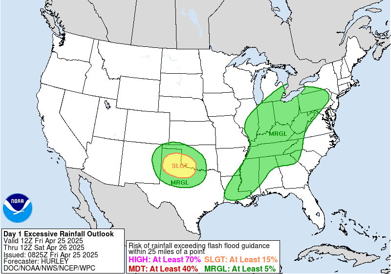
As was the case yesterday, these thunderstorms will be slow moving and could produce locally heavy rainfall (radar estimates showed a couple of spots greater than 5” on Thursday). Hence some isolated flash flooding issues could develop, and the Weather Prediction Center has placed a slight risk (level 2 of 4) of flash flooding in this same general area.

While most of the severe weather will be focused in this area, much of the country will have risks for rain and storms today as weak weather systems move across the region. A stronger upper level weather system will move across the Northeast, bringing rain and a shot of cooler weather for the weekend. The upper level weather system I have been discussing this week off the west coast will intensify and start to move into the western United States, bringing some lower elevation showers and mountain snow.
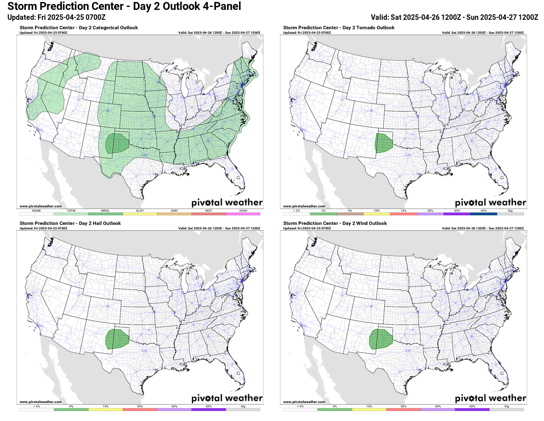
For Saturday, SPC has a marginal (level 1 of 5) risk of severe storms in northwest Texas in what looks to be a transition day before the western US system begins to move far enough east to start increasing severe weather risks in the Plains on Sunday.
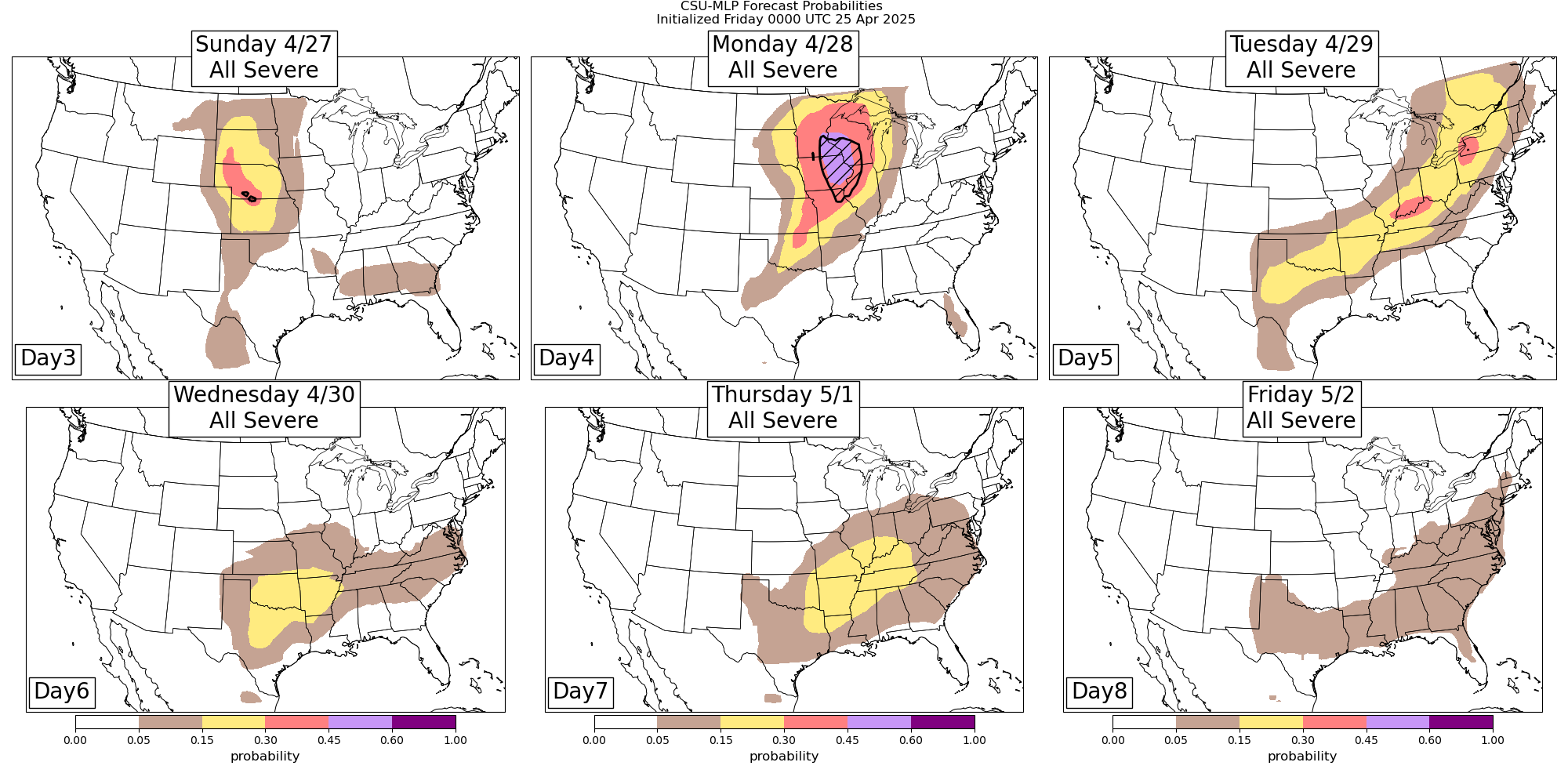
By Sunday afternoon, the risk of severe weather will increase across the central and northern Plains with potential supercell severe storms with very large hail, damaging winds and possibly tornadoes. The risk of severe storms looks to peak on Monday with a potential high end severe weather day for the upper Midwest, Missouri Valley and Mississippi Valley regions. As the upper level system moves across the northern Plains Monday, strong winds throughout the atmosphere will spread across this region where unseasonably high low level moisture and instability will exist. This should support a number of intense supercell severe storms with the potential for strong tornadoes and very large hail. The CSU-MLP system shows very large area of greater than 30% probabilities of severe weather along with hatched probabilities for significant severe weather (strong tornadoes, 2”+ hail, 75+ mph wind gusts). Obviously this is a system that will bear close watching this weekend.
As we have seen several times already this spring, this upper level weather system will weaken substantially as it moves east into a strong upper level ridge of high pressure, and the associated cold front will slow and stall out from the eastern Great Lakes to the southern Plains. Severe weather will be possible along the front Tuesday, and then by the middle of next week should become more focused in the south central United States as a new upper level weather disturbance moves out of the Southwest and interacts with the old front.
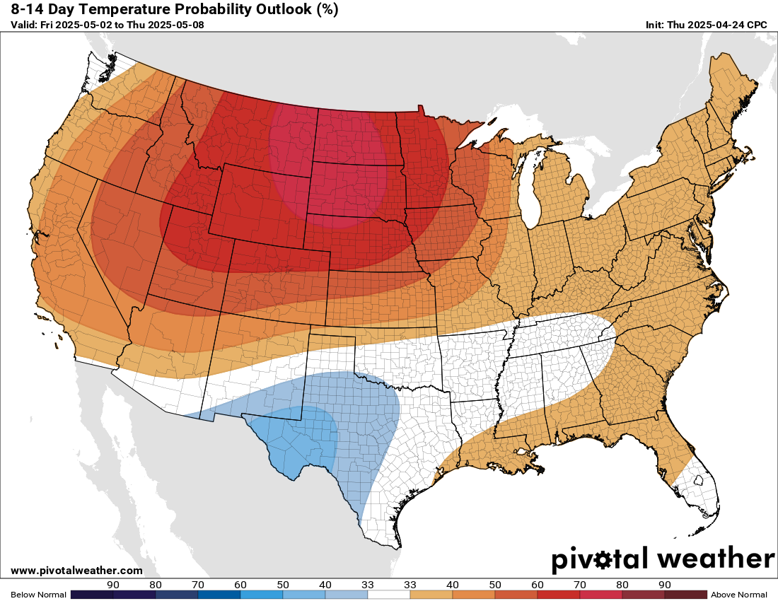
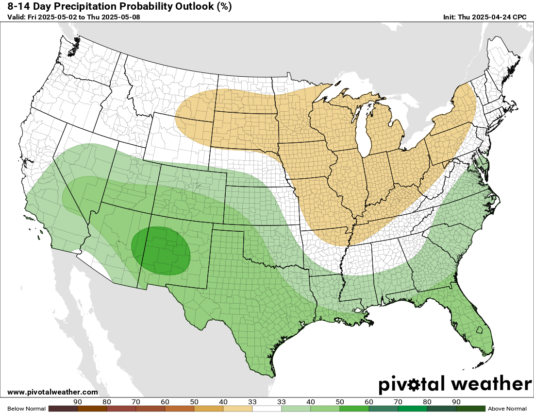
Looking out into week 2, the long range ensemble models suggest a pattern with an unusually strong upper level ridge of high pressure across the northwest and north central part of the country, with an active southern branch of the jet stream across the southern tier. This means a much greater risk for above normal temperatures for the northern US, while the southwest has a greater risk of above normal precipitation, which would be welcome given the ongoing drought in this region.

Leave a comment