And NOAA science intercepts tornadoes on the Plains
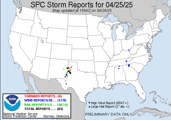
Welcome to the weekend. The work week closed with another active severe weather day on the Plains of west Texas and extreme eastern New Mexico. Over 50 reports of large hail, damaging winds, and tornadoes were received by the Storm Prediction Center (SPC).


For the second consecutive day, the National Severe Storms Laboratory led Low-Level Internal Flows in Tornadoes (LIFT) field research project deployed in the region and intercepted a tornadic supercell. The primary goal of LIFT is to better understand the near surface wind flow in and around tornadoes, not only to improve forecasts and warnings but also to understand how tornadoes interact with the natural and built environment and produce damage. For LIFT, NSSL is partnering with Texas Tech University and the University of Oklahoma through the Cooperative Institute for Severe and High-Impact Weather Research and Operations (CIWRO) to deploy mobile radars, Doppler lidar, and other mobile observing platforms within a couple of miles of the tornado to collect data.
NSSL scientist Mike Coniglio said on Facebook that the team captured the full lifecycle of a tornado with their Doppler lidar on Friday, which the team believes is the first time that has been done. Doppler lidar data will give the research team unique insight into the tornadic windflow. It is important to realize that this is another example of the type of research that would be halted if the Office of Management and Budget FY2026 budget plan to eliminate NOAA Research and the NOAA Cooperative Institutes comes to fruition.

As I talked about in yesterday’s newsletter, the slow movement of these thunderstorms meant that locally heavy rainfall occurred. A few spots along the Texas/New Mexico border received greater than 5” of rainfall per MRMS estimates, causing some flash flooding. Local amounts greater than 4” along occurred in parts of the lower Mississippi Valley region.

Today the focus of any severe weather or flash flood risk is expected to be in southern Oklahoma and northern Texas where a couple of slow moving complexes of thunderstorms will occur. Scattered to numerous showers and thunderstorms will be possible over a large part of the eastern two-thirds of the country, with an upper level weather disturbance bringing cooler air and some wintry precipitation to the Northeast. An intensifying upper level weather system moving into the western United States will bring some lower elevation rain showers and mountain snows to that region.
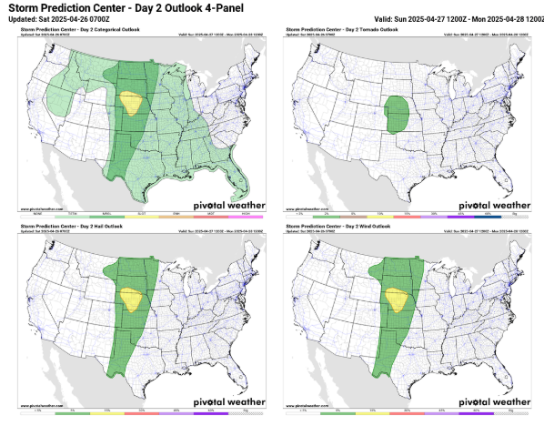
That strong upper level weather disturbance in the West will begin to pull into the Plains on Sunday, bringing some increase in risk for some severe thunderstorms, with the greatest risk over Nebraska where a slight (level 2 of 5) risk is in place.

This weather system will also bring increasing fire danger to the Southwest this weekend. On Sunday, extremely critical fire danger with strong winds and single digit relative humidity values is forecast for parts of New Mexico and west Texas, including the Albuquerque and El Paso areas.


As the strong upper weather system moves out into the northern Plains on Monday, it will interact with an unusually moist and unstable airmass for April in the upper Midwest to set the stage for an outbreak of severe thunderstorms. SPC has already placed a moderate (level 4 of 5) risk of severe storms for parts of the region including the Twin Cities and Des Moines metro areas. Conditions appear favorable in this region for intense, long-lived supercell thunderstorms capable of very large hail and strong tornadoes, and SPC stated in their discussion this morning that a tornado outbreak is possible. Favorable conditions for more isolated severe storms with significant severe weather will exist southwest into Oklahoma along a slow moving cold front.
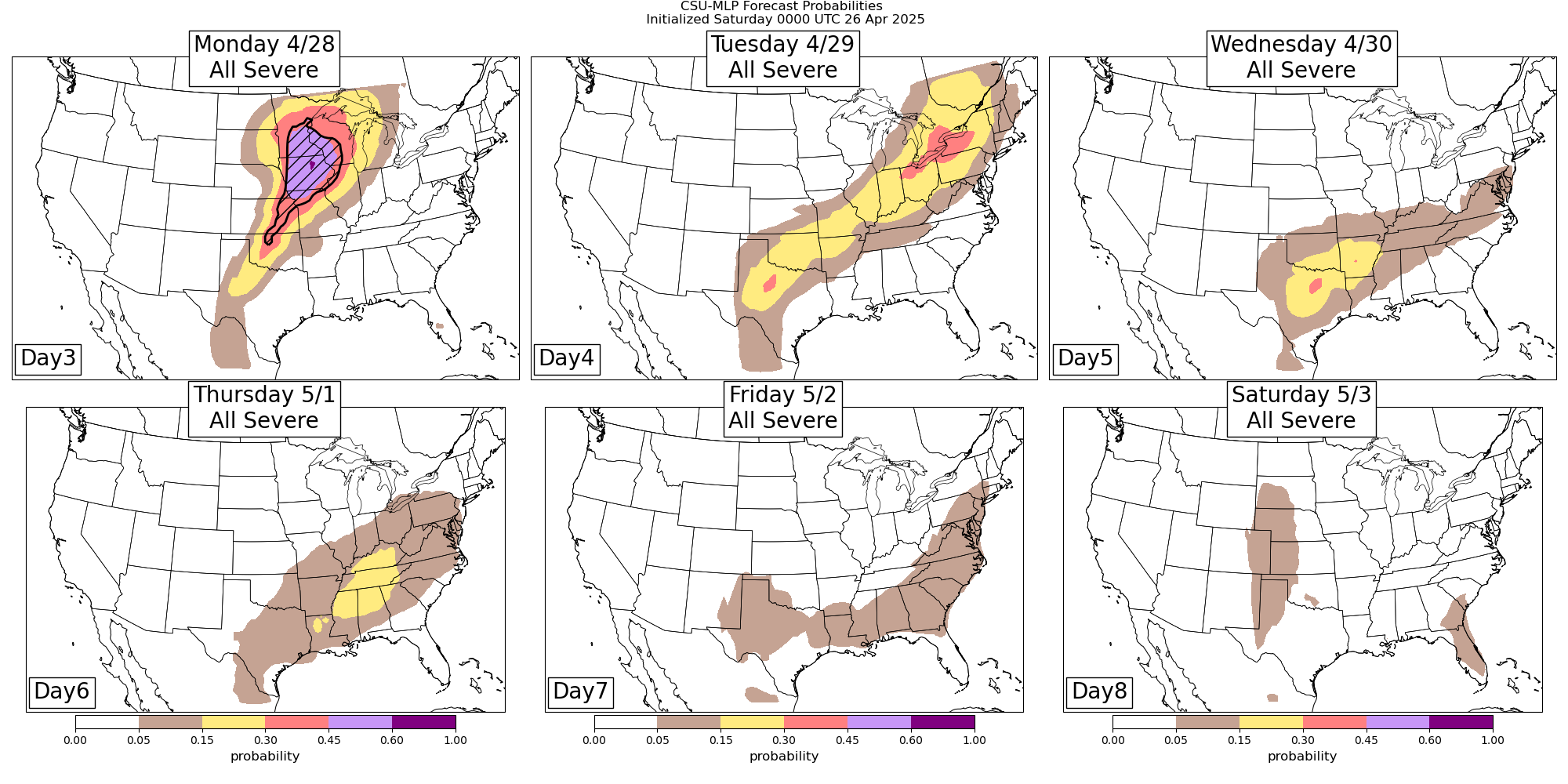
A continued risk of severe storms will exist along the stalling cold front from the eastern Great Lakes region to the Southern Plains on Tuesday. As a new upper level weather disturbance comes out of the Southwest and interacts with the front, additional risks for severe storms are expected Wednesday and Thursday.

Leave a comment