Starts with serious severe weather risk today

Good Monday morning, lots of weather to talk about today. Let’s start with a recap of yesterday. Significant severe weather occurred last evening over parts of South Dakota and northwest Nebraska where several supercell severe storms developed. One particularly intense supercell west and northwest of Hyannis, NE was a cyclic tornadic supercell – “cyclic” meaning that it went through several cycles of intensifying and producing a tornado, then that tornado would weaken and a new area of rotation would develop and start the cycle again.
My colleague Noah Brauer posted a great radar loop on BlueSky that showed part of this process. Chasers reported that at least one of the tornadoes with this storm was a very large wedge tornado that caused a train derailment. Luckily the area where this occurred is very rural, but it will still be interesting to see what the results of damage surveys are.

As we are in the heart of spring severe thunderstorm season, it is not too surprising that this week looks to be very active. It will start off today with a potential outbreak of severe storms, focused on the upper Midwest but with significant risks of severe weather down into the Southern Plains. The NWS Storm Prediction Center has a moderate (level 4 of 5) risk of severe storms for parts of southern Minnesota, northern Iowa, and western Wisconsin, with surrounding areas in an enhanced (level 3 of 5) risk. To the southwest of there, a large slight risk extends down into west Texas, with another enhanced risk from western Oklahoma into northwest Texas.
The thunderstorm evolution today still looks rather murky with a number of scenarios possible. The large upper trough of low pressure we have been discussing over the western United States will shift east today, bringing an area of strong southwesterly winds in mid levels of the atmosphere into the severe weather risk area. This will provide strong wind shear to a large area from Texas to Minnesota that will also become very unstable this afternoon, a combination which is favorable for intense supercell severe storms that could produce very large (greater than 2”) hail, strong tornadoes, and damaging winds.
While conditions will be very supportive of severe storms, the question will be if and how many storms develop. The upper level trough is nearing its peak intensity and will start to weaken later today into tonight. Thus while environmental conditions are favorable for severe storms, the forcing for thunderstorm development will be weakening somewhat with time. Not surprisingly given the somewhat nebulous setup, the high resolution models each have their own scenario for when and where storms will develop, increasing forecast uncertainty.
The moderate risk area is the area that not only has the strongest forcing for severe storms, but it also is the most supportive of intense tornadoes given the presence of strong wind shear in lower levels of the atmosphere. Right now, the most likely scenario seems to be that a few intense supercells will develop in southern Minnesota and/or northern Iowa (and possibly southeast South Dakota) later today and move east-northeast across the region into Wisconsin tonight with potential significant severe weather associated with them. Farther southwest, a few intense supercells should develop along the cold front extending to the southwest into Texas. A secondary corridor of focused activity appears probable in Oklahoma or northwest Texas where a secondary piece of upper level energy may provide additional forcing for thunderstorm development.
I will be providing additional updates for today’s weather via social media (Facebook, BlueSky) and Substack Notes. For paid subscribers, I am planning to do live Substack Chats this afternoon and evening, as well as possibly some video updates.
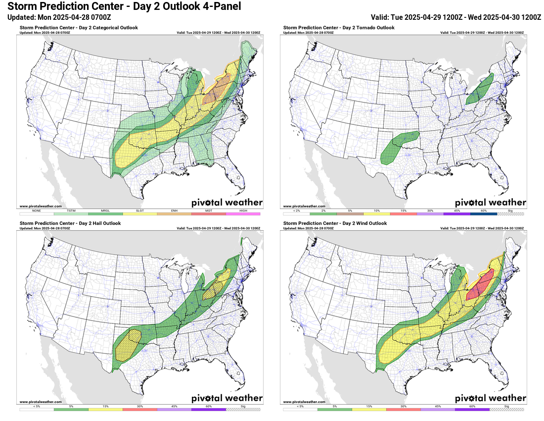
Tomorrow will see the threat of severe weather continue along the front as it slows and starts to become stationary from the Northeast into Texas. As is the case today, the exact evolution of storms is uncertain on Tuesday with a large area of conditions favorable for severe storms but weaker forcing for storm development. SPC has an enhanced (level 3 of 5) risk in the eastern Great Lakes region where the strongest forcing along the front looks like it could produce an organized line of severe storms with damaging winds, large hail and possibly a tornado.
As a new upper level low pressure area develops over the Southwest US, it will produce more focused and intense thunderstorm development Tuesday afternoon and night over parts of northwest Texas and southwest Oklahoma that will spread northeast. SPC shows a risk of very large hail in this area as conditions will be favorable for intense supercell thunderstorms as the storms initially develop.


Flash flooding will be a growing concern in this area as well. Ground conditions have become quite wet over this region with multiple thunderstorm events over the last 10 days producing widespread 4+” of rain. Additional rainfall will quickly runoff and potentially produce flash flooding. The NWS Weather Prediction Center has a moderate (level 3 of 4) risk of flash flooding along the Interstate 44 corridor in Oklahoma, southwest Missouri and northwest Texas.


The Southwest US weather system will move slowly east Wednesday, bringing additional risks for severe weather and flash flooding to the south central United States. Some threat will likely continue on Thursday into the Midwest and Ohio Valley but at this point things are still uncertain to define any specific risk areas. Beyond Friday, the longer range ensemble models are now suggesting another large upper level low pressure area will evolve in the Southwest US by late this weekend, and this could result in a more active weather pattern for the central United States early next week.

Leave a comment