And potentially serious flash flood issues loom for parts of south central US
As we go into May and eventually summer, overall there tend to be more surprises when it comes to forecasting thunderstorms and severe weather. The development and evolution of thunderstorm complexes tend to be governed less by larger scale (synoptic) systems, and more controlled by what is happening within the thunderstorms themselves, what meteorologists call “storm-scale.” The storm-scale is what we are trying to capture with high resolution models, and while the US weather community has the best high resolution storm-scale models in the world, overall forecasts at that scale are more difficult and prone to error than forecasting large scale weather systems.

So that brings us to the last 24 hours. At a high level, the severe weather forecast for yesterday was not too bad, as there were three main areas of severe storms similar to what we discussed in yesterday’s newsletter: southern Minnesota/northern Iowa, northeast Kansas, and northwest Texas/Oklahoma. There were plenty of very large hail and damaging wind reports from severe storms in all three areas. Where the forecast went awry was the tornadoes: there were very few, and as of now there do not appear to have been any particularly intense tornadoes. While that is obviously a good thing, it was not what was anticipated, so meteorologists will want to understand what went wrong.
It seems to me like in all three areas the storms quickly organized into lines and clusters. While strong tornadoes can occur within storms organized like that, they do not produce them with the frequency that isolated supercells do, and they have to be organized and oriented a certain way that the storms last night were not. I am sure that meteorologists in the affected areas – especially the upper Midwest where the moderate risk was in place – will be looking at this more closely. One encouraging sign is that some of the high resolution models suggested that the storms would not be as tornadic as the overall setup suggested, so improving models and understanding could yield a better forecast in similar situations going forward.


And then there was late last night into this morning. A complex of severe thunderstorms organized over Oklahoma and moved up Interstate 44 into southwest Missouri as a strong bow echo, producing significant wind damage. The official NWS observing site at the Springfield, MO airport reported a wind gust of 90 mph as the bow echo moved through there. More than 20,000 customers are without power in southwest Missouri per PowerOutage.us.
This was a surprise too (at least to me). While some of the evening high resolution models last night did forecast a complex of strong storms with gusty winds over northeast Oklahoma in the pre-dawn hours, none of them organized and intensified the complex and moved it northeast into southern Missouri the way that actually happened in the atmosphere.
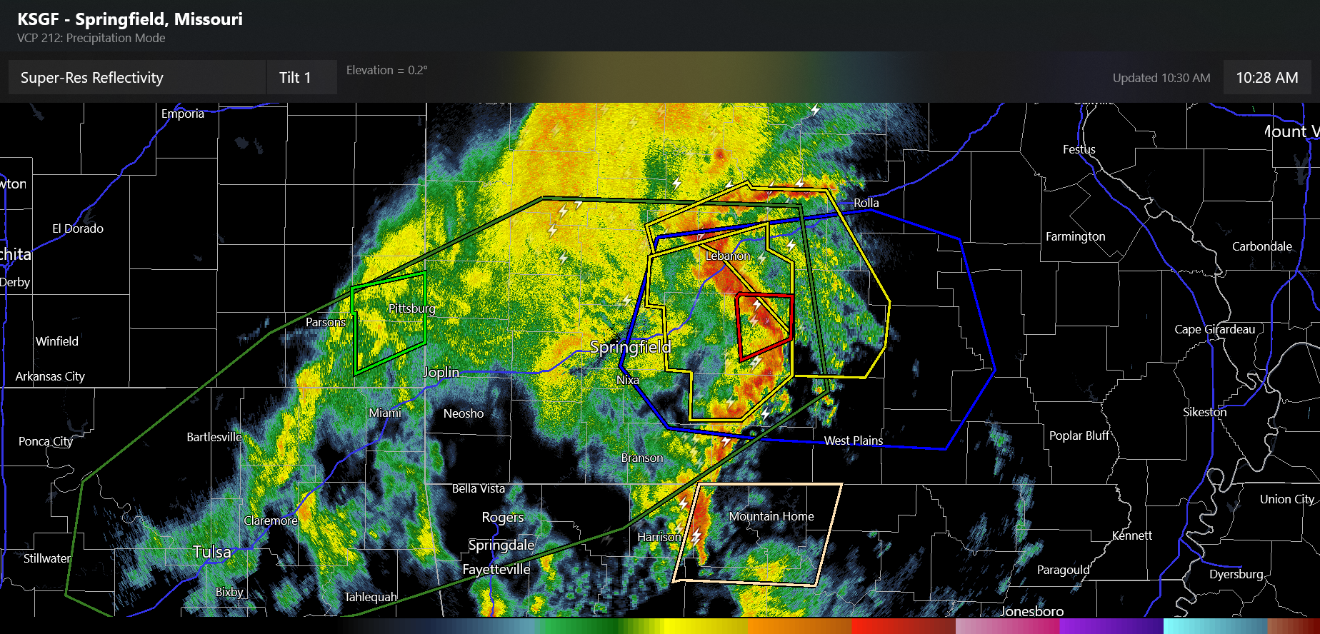
This complex of severe storms is still rolling across southern Missouri, producing significant wind damage and potentially some embedded tornadoes. The morning high resolution models are still struggling with this system, but it has clearly become well organized and observations would suggest it will maintain itself for at least a few more hours as it moves toward southeast Missouri, southern Illinois and western Kentucky.
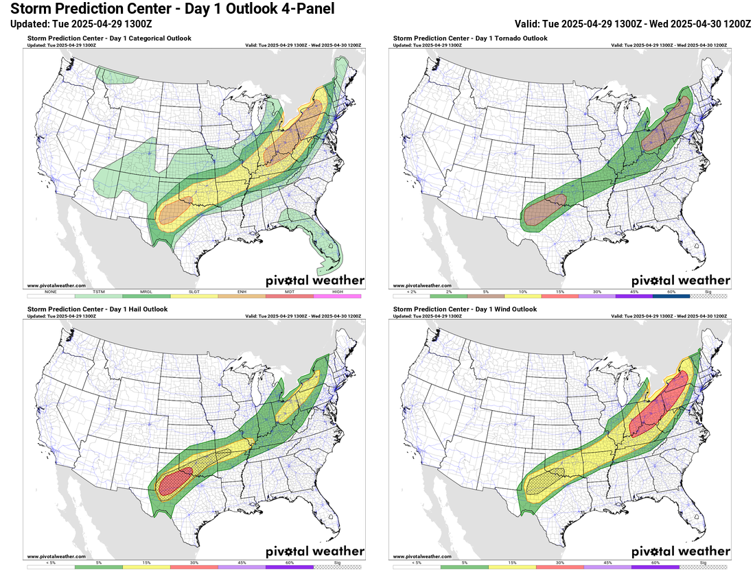
Elsewhere today, there appear to be two other main areas of focus for severe weather. The first is in the eastern Great Lakes and upper Ohio Valley where a couple of bands of severe storms will move quickly east along and ahead of the slow moving cold front moving across the region. Damaging winds appear to be the main threat here, but large hail and a few tornadoes are also possible.
The second area is from northwest Texas into Oklahoma, where an approaching strong upper level weather disturbance will interact with the nearly stationary front to initiate several intense supercell storms over northwest Texas this afternoon. These storms should then organize and move across southern and eastern Oklahoma tonight. Very large hail, damaging straight line winds, and a few tornadoes appear likely with the most intense of these storms.
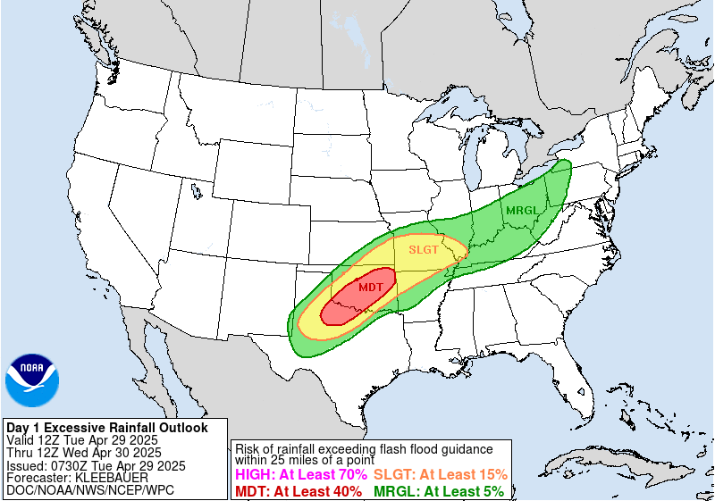
In addition to the severe weather risk in Texas and Oklahoma, there is serious concern for flash flooding as well. As I discussed in yesterday’s newsletter, much of this region has been very wet over the last 10-14 days, and many areas saw additional heavy rainfall in the last 24 hours. Multiple rounds of strong thunderstorms producing intense rainfall rates on top of this wet ground is likely to result in some significant incidences of flash flooding. The Weather Prediction Center continues to have a moderate risk (level 3 of 4) of flash flooding in place along the Interstate 44 corridor from northwest Texas across Oklahoma, with a slight risk up across southern Missouri.
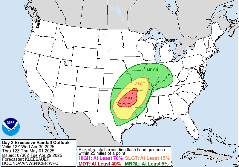
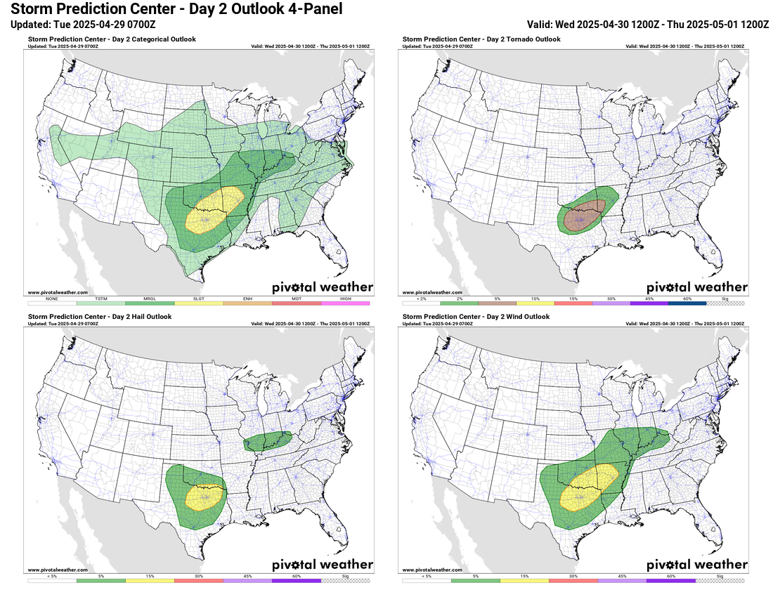
The upper level weather disturbance coming out of the Southwest US will continue to move slowly east on Wednesday, resulting in additional rounds of severe storms with very heavy rainfall. The morning high resolution models suggest another very active day across southern Oklahoma and northern Texas, spreading into western Arkansas. Of particular concern are model rainfall forecasts which suggest totals of 5-10” over the next 48 hours could be common; given the antecedent conditions, this could result in widespread, significant flood and flash flood issues.
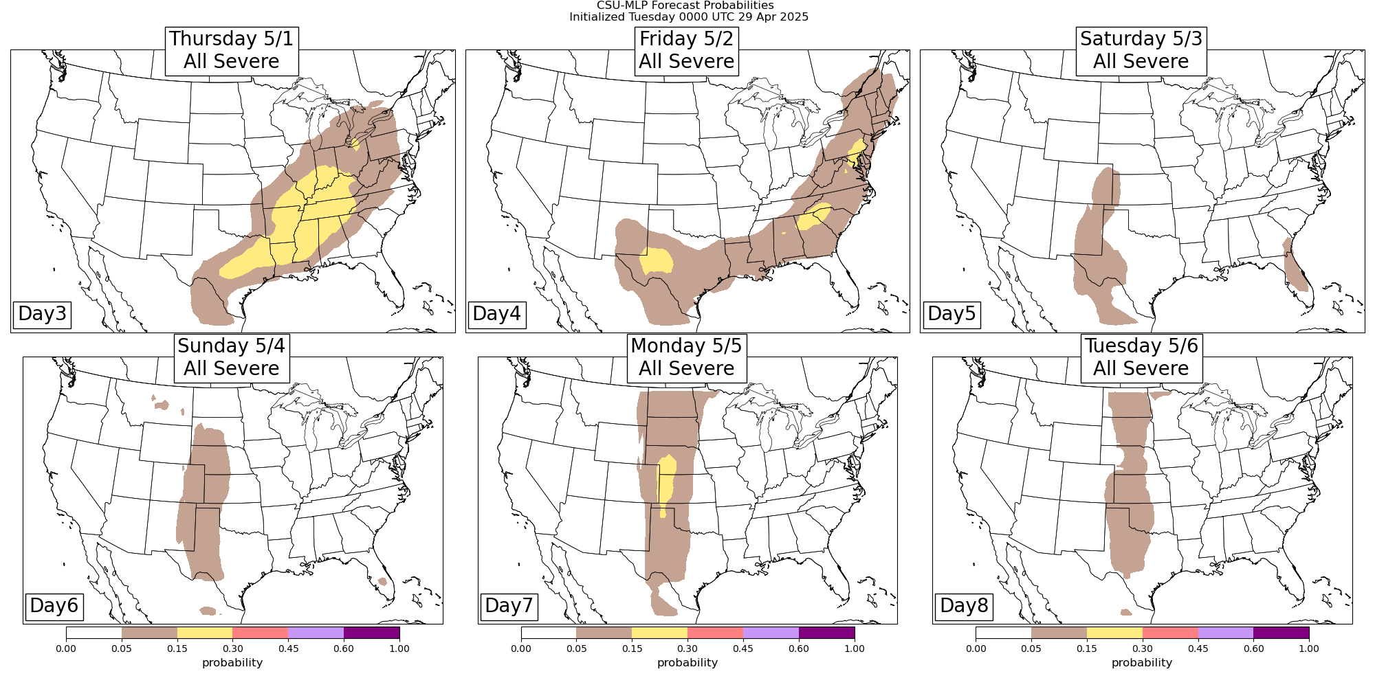
There was so much to talk about in the previous 24 hours and upcoming 48 hours, I am just going to quickly cover the longer range beyond Wednesday. As the upper level weather system driving the severe weather and flash flooding over the south central US continues to move east on Thursday, there will additional risk for severe weather from the Ohio Valley into the lower Mississippi Valley. That system will continue east for Friday, and then by early next week a new strong Southwest system should reload the severe weather risk for the Plains region.
I will be continuing to provide updates on the ongoing weather via social media, Substack notes and periodic Substack posts. I will also be doing occasional videos and Substack live chats where I provide real-time updates using radar, satellite, and observations; those are paid subscriber benefits, so if you would like to support this work and get access to those features, the link is below.

Leave a comment