And recapping the busy last 24 hours of severe weather and flash flooding
Weather is a humbling business to be in. Yesterday’s newsletter started out with a discussion of why Monday’s severe weather did not end up as impactful as forecast; today’s will start off with a discussion of why Tuesday’s severe weather ended up being more impactful than forecast, and certainly more impactful than Monday’s severe weather.
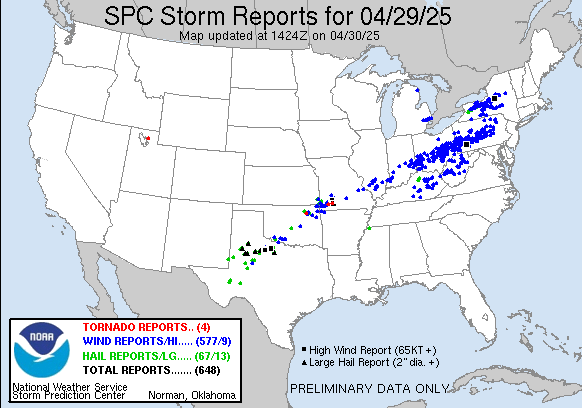
Over 600 reports of severe weather were received yesterday by the Storm Prediction Center along a large swath from northwest Texas to New York state.

The most societally impactful severe weather was from Ohio across Pennsylvania into New York where hundreds of reports of wind damage were received. The practically perfect wind probabilities – taking the actual severe weather reports and mapping them to show what the SPC forecast would have been had it been perfect – had a large area of 60% probabilities, indicative of a moderate to high risk type of day for wind damage.
While the probabilities may be a bit inflated due to report saturation, i.e., lots of reports of relatively minor events, there is no question that this was a major societal impact event for the region. As the radar loop above shows, the primary culprit for much the damage was a well organized bow echo complex of severe storms that moved across central Ohio, the West Virginia panhandle, and much of Pennsylvania. This radar presentation is extremely impressive, with 80 to 90 mph winds aloft pushing into the back of the complex (what meteorologists call the rear inflow jet) and similar strength winds observed lower down at the leading edge of the storms.
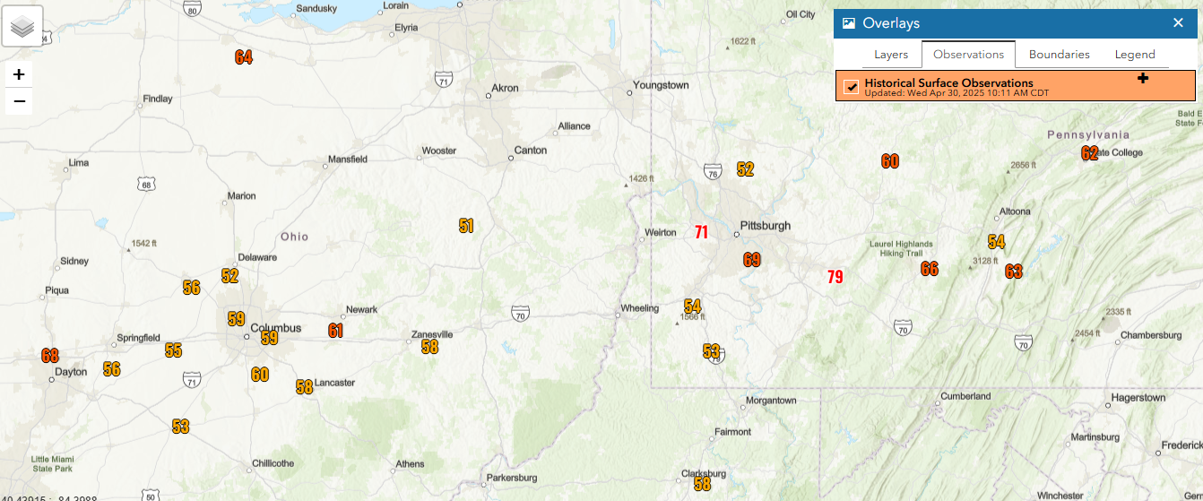
Often with thunderstorm wind events in the East, the damaging wind gusts tend to be rather isolated and sporadic, and those damaging gusts are thus more infrequently measured at official observing sites than tends to be seen in the Plains states. That was not the case with this event, as numerous NWS observing sites reported wind gusts of severe levels – 50 kt or 58 mph – all across central Ohio and western Pennsylvania as you can see above (note that Wheeling, WV had at least 70 mph gusts but their data for yesterday was incomplete which is why it does not show on the map). 79 mph at Latrobe, PA was the highest reported at an official site.
Damage from this storm complex was extensive, with nearly 750,000 customers in Pennsylvania, West Virginia and Ohio without power at one point; as of this morning, 500,000 are still without power. Additional severe thunderstorms producing damaging winds occurred in New York State where tens of thousands were without power, and also in Ontario where more than 100,000 customers lost power (thanks to Canadian colleague Dave Sills for that report). Two people died in Pennsylvania after being electrocuted by downed powerlines. The storm complex we discussed yesterday in Missouri also continued on east into the Ohio Valley and also caused numerous incidences of hail and wind damage.

Farther west, severe thunderstorms caused additional reports of large hail, damaging winds and a few tornadoes across northwest Texas and southern Oklahoma. As the severe storms organized into a large, slow moving storm complex late in the evening and overnight, it also produced very heavy rainfall that caused flash flooding with numerous road closures and water rescues reported. The official Oklahoma City observation site at OKC Will Rogers Int’l Airport set a new record for the wettest April on record this morning, reaching (at least) 12” for the month (the old record was 11.91”).

Let’s finally turn our attention to what is to come today. A band of strong to severe storms continues across southeast Oklahoma and north Texas this morning. This activity will move slowly east and southeast the next several hours, while daytime heating ahead of the line will cause the atmosphere to become increasingly unstable. This should support further intensification of these storms and additional severe weather today across the Arklatex region.
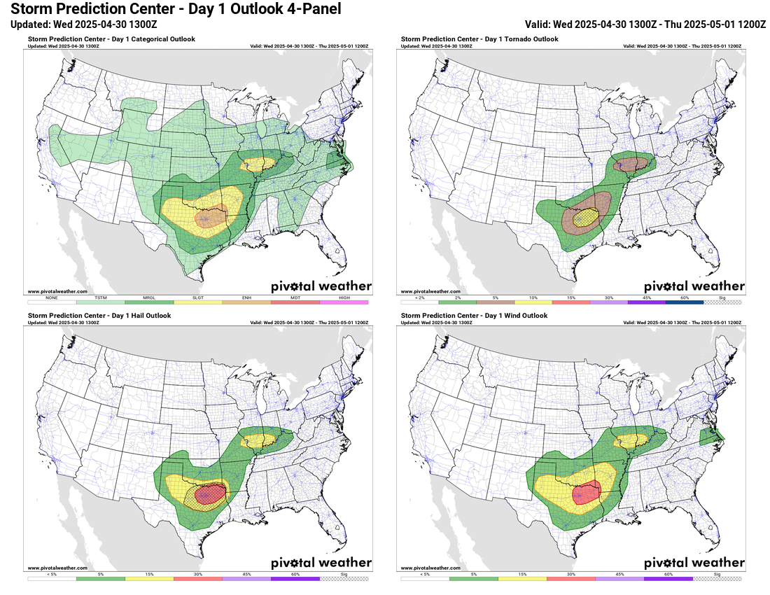
SPC has an enhanced (level 3 of 5) risk in this area for storms capable of producing very large hail, damaging winds and a few strong tornadoes. Additional supercell severe storms could also redevelop farther west over northwest Texas into western Oklahoma this afternoon and evening. Also, scattered thunderstorms should redevelop across the mid-Mississippi Valley this afternoon where conditions will remain somewhat supportive of severe storms, and SPC has a slight (level 2 of 5) risk in this region.

Of course, given the slow movement of this weather system and the very heavy rain associated with the strong thunderstorms, flash flooding will remain a significant concern today into tonight. The Weather Prediction Center has a moderate (level 3 of 4) risk of flash flooding out for the Arklatex region. The morning high resolution models suggest there will be occasional periods where the complex of storms will stall out for a time, and in these areas more than 5” of rain could occur in less than 6 hours, which could result in serious flash flooding.

On Thursday, the upper level weather system responsible for the severe weather in the south central US the last couple of days will lift northeast toward the Ohio Valley. Ahead of the system moist and unstable air will support scattered to numerous thunderstorms, some of which could be severe with damaging winds the main threat. SPC has a large slight (level 2 of 5) risk in place from east Texas to the lower Great Lakes region. Organized heavy rainfall is not anticipated on Thursday, but some locally heavy rainfall with thunderstorms could still cause some isolated flash flooding.
I will be continuing to provide updates on the ongoing weather via social media, Substack notes and periodic Substack posts. I will also be doing occasional videos and Substack live chats where I provide real-time updates using radar, satellite, and observations; those are paid subscriber benefits, so if you would like to support this work and get access to those features, the link is below.

Leave a comment