And severe weather/flash flood risk today
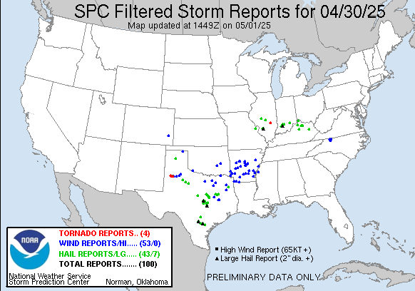

Welcome to May! A quick recap of the last 24 hours: overall, the forecast for yesterday seems to have worked out fairly well, with the focus of severe weather being on the slow moving complex of severe storms over the Arklatex, but a few scattered severe storms as well in the mid-Mississippi and Ohio Valleys and southern High Plains. The axis of heaviest was in northeast Texas and northwest Louisiana where the MRMS analysis shows a swath of 4+”; this produced some scattered reports of flash flooding. Daily record rainfalls were set at Dallas-Fort Worth, Shreveport, Longview and Tyler TX.
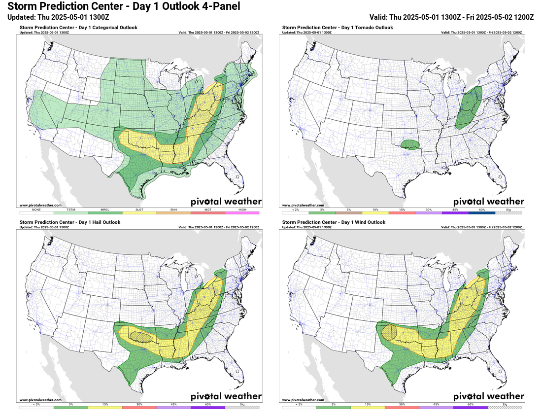

For today, a broad area of the country from the Great Lakes south to the lower Mississippi Valley and then northwest into the Southern Plains will have a slight (level 2 of 5) risk of severe storms. There are two areas within this broader area that seem to have more focus for thunderstorm activity. The first is over the eastern Great Lakes region where the system that produced all the severe weather and flooding over the south central US will be impacting today. While the system will be weakening, it could still provide some enhancement to the severe weather threat as well as a bit higher potential for training storms that could produce some flash flooding. The Weather Prediction Center has a slight (level 2 of 4) risk of flash flooding there.
The other area is over the Texas Panhandle into Oklahoma. The next upper level disturbance will be dropping south through the central Plains later today. Along the southern edge of that system, moisture and instability will be moving back northwest and will interact with the disturbance to support the development of supercell thunderstorms late today capable of producing very large hail and damaging winds. These storms will move east and likely organize into another complex of storms that will move across Oklahoma tonight with a continued risk for large hail, damaging winds and possibly a tornado.
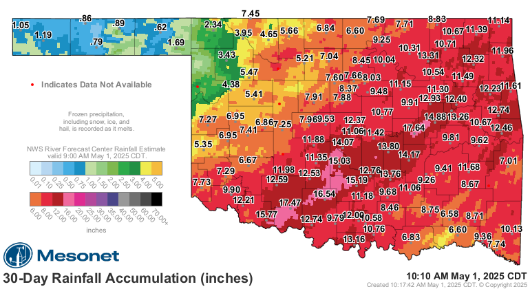
The exact evolution of the thunderstorm complex is still somewhat uncertain, but some areas of Oklahoma will likely see 1 to 3 inches of additional rainfall. Much of the state has seen very heavy rainfall over the last few weeks, with Oklahoma City setting a record for April rainfall with a total of 12.55”. Given the wet conditions and many streams and rivers already being in flood, any additional heavy rainfall could cause flash flooding. WPC has a slight (level 2 of 4) risk of flash flooding outlooked for the southern half of the state.

For Friday, a risk of severe weather along with localized heavy rain and flash flooding will continue from Texas northeast into the Tennessee Valley as the upper level system and associated cold front continue to move slowly east.
A change is in the air

The forecast for the weekend into early next week has changed quite a bit in the last couple of days, and it is worth a discussion of why. The graphic above is the 500 mb forecast for Sunday evening from the most recent European ensemble model. 500 mb is about 18,000 ft up in the atmosphere, and it is at this level that meteorologists are generally looking when they talk about mid and upper level weather systems. The lines on the map are heights – similar to isobars or lines of pressure on a typical surface weather map – and the image is the anomaly, how much the forecast height differs from the normal. By Sunday evening, the model is showing two rather strong upper level areas of low pressure, one over the southwest United States and the other centered over the Ohio Valley.
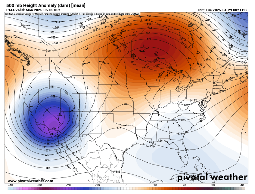
The system over the Southwest was anticipated; the one over the East was not. This is the 500 mb forecast for the same time on Sunday as the most recent one I showed above, only from the forecast produced Monday night. As you can see, the low pressure center over the Ohio Valley is nowhere to be seen, rather just a weak trough of low pressure. One thing you can see in both maps is the dark red showing much above normal heights over the Great Lakes and southern Canada. The models can struggle when there is a pattern like this with unusual areas of high pressure aloft at high latitudes, and that is the case here.
The system I discussed above moving across the Central Plains tonight will be moving south of the high pressure area over the Great Lakes and Canada. This is a very sensitive kind of pattern for the atmosphere as the unusual high pressure so far north can support slow moving upper lows south of it. In this particular situation, the low pressure system and the high pressure system are both a little stronger than forecast a few days ago, and now support a dramatically different overall weather pattern where the low pressure will in fact intensify south of the high and become a strong, slow moving upper level low pressure center.
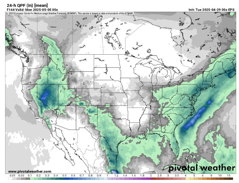

This has profound changes to the forecast for the Eastern US this weekend. The top map here is the 24 hour forecast rainfall from the Monday night European ensemble model, ending at the same time Sunday evening; it hints at some light rain over the East. Compare that to the bottom image which is the forecast rainfall from the most recent model run – much wetter with moderate to heavy rain all the way back into Illinois.
The bottom line is that we will have a quite wet and unsettled weekend for both the eastern third of the country and the western third of the country. Some late season high elevation snows can be expected in the west.

As far as severe weather, there will be some risk of severe storms on Saturday to the east of the upper level low pressure system. The stronger upper level low over the east means that the Southwest upper level low will be “blocked” and slower to move east than earlier models were showing. This will likely mean that the threat of severe storms in the Plains next week will be focused in the far western High Plains and be slower to develop than earlier forecasts had shown.

Leave a comment