And more heavy rain and storms for Texas

Welcome to the weekend! As anticipated, yesterday was quite active along the old stationary front, with nearly 400 reports of large hail and damaging winds from Texas northeast to the eastern Great Lakes. Luckily, though, there were no tornadoes reported and only a handful of significant severe reports, primarily some very large hail to baseball sized in Texas as well as a tennis ball sized hail report from Belmont County, OH.

Today the weather pattern we have been talking about of slow moving upper level low pressure centers in the Ohio Valley and the Southwest will start to fully take shape. This will result in wet weather for much of the East with scattered to numerous showers and thunderstorms. A few severe thunderstorms with strong winds and hail are possible across this region. The greatest risk looks to be from the central Appalachians into southern New England where the Storm Prediction Center has a slight (level 2 of 5) risk of severe weather today. The Southwest US upper low will bring the West scattered lower elevation showers and storms as well as some late season mountain snow.
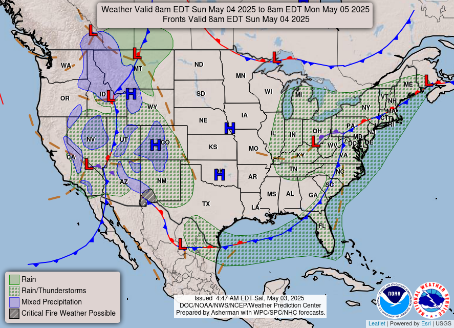
With this slow moving “blocked” weather pattern, things will be fairly similar on Sunday. The Southwest system will move a bit east, spreading the risk of rain and snow a bit farther east and northeast.

Early next week, both upper level lows will continue to move slowly east. The Southwest system will become an increasing focus for hazardous weather risks as it begins to interact with moisture and instability coming northwest from the Gulf. Severe thunderstorms with damaging winds and potentially very large hail will be possible over much of Texas on Monday, with the risk shifting east into the Arklatex and lower Mississippi Valley regions on Tuesday and Wednesday.


The risk of heavy rainfall and flash flooding will also evolve similarly, and Tuesday looks to be a day with potentially significant flash flooding risks as thunderstorms with intense rainfall rates become more widespread over areas that have seen particularly wet conditions the last several weeks. The Weather Prediction Center already has a moderate (level 3 of 4) risk of excessive rainfall over the Arklatex region. A slight risk extends northwest across Oklahoma; rainfall totals are expected to be less here than to the southeast, but much of the state has been inundated with heavy rainfall the last few weeks so it will not take as much rain to cause flash flood concerns.
With the eastern US system, showers and thunderstorms will become more focused in the Northeast for the early part of next week. While much of this area has been in drought conditions, several days of moderate to heavy rainfall could eventually cause some minor flooding issues and WPC has a marginal (level 1 of 4) risk in this area for Monday and Tuesday.
By late next week, the eastern upper low will finally weaken and move off the coast, while the western upper low will drift southeast toward the Gulf Coast states. This will likely bring unsettled conditions to the Southeast including at least a low risk of severe thunderstorms to the region – including parts of Florida – for late in the week.

Leave a comment