And monitoring flash flood risks in the Southeast today

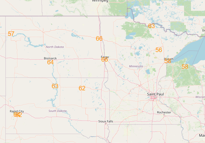
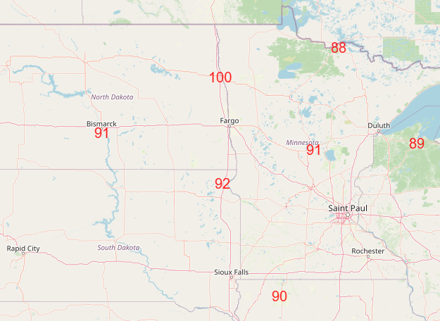
Good morning and welcome to a new work week. Starting off today by recapping a day of crazy warmth in the upper Midwest on Sunday. Highs in the 90s were common across the Dakotas and Minnesota, with a 100F at Hallock, MN. Dozens of record warm temperatures were set – both maximums and high minimums – not only in the upper Midwest, but also in the Southwest.
The upper Midwest though was where the most records were reached and where some records were pulverized. International Falls, MN reached 96F, which not only broke the daily record by 13 degrees, it also set the record warmest temperature for the month of May and warmest so early in the season. Needless to say, in a month like May where we are rapidly transitioning toward summer and hotter weather, it’s pretty remarkable to set a monthly record on the 11th day of the month. Even more impressive is that International Falls is a core long term climate site, with observations dating back to 1895. Other record highs on Sunday included the Twin Cities at 90F (previous record 88F in 1900), Minot ND at 99F (previous record 95F in 1906), 95F at Rapid City SD (previous record 87F in 1958), and 96F at Bismarck ND (tied record set in 1906).

The record warmth will continue in the upper Midwest through tomorrow ahead of a storm system organizing over the western states.
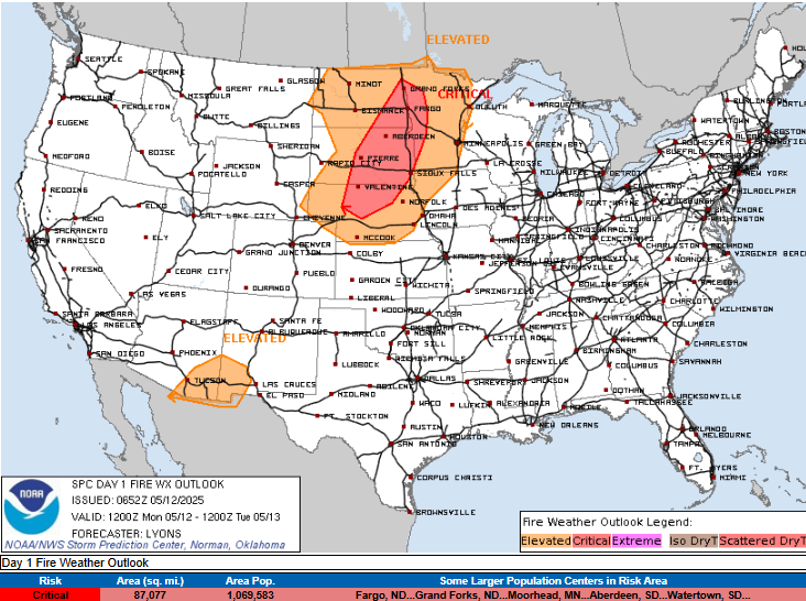
Along with the record heat, gusty winds and dry conditions will yield critical fire danger in the upper Midwest today as well.
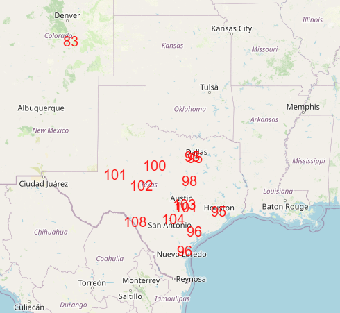
Record warmth will also develop in Texas on Tuesday, starting a trend of record warmth that will persist in the southern and eastern parts of the country through the end of the week.
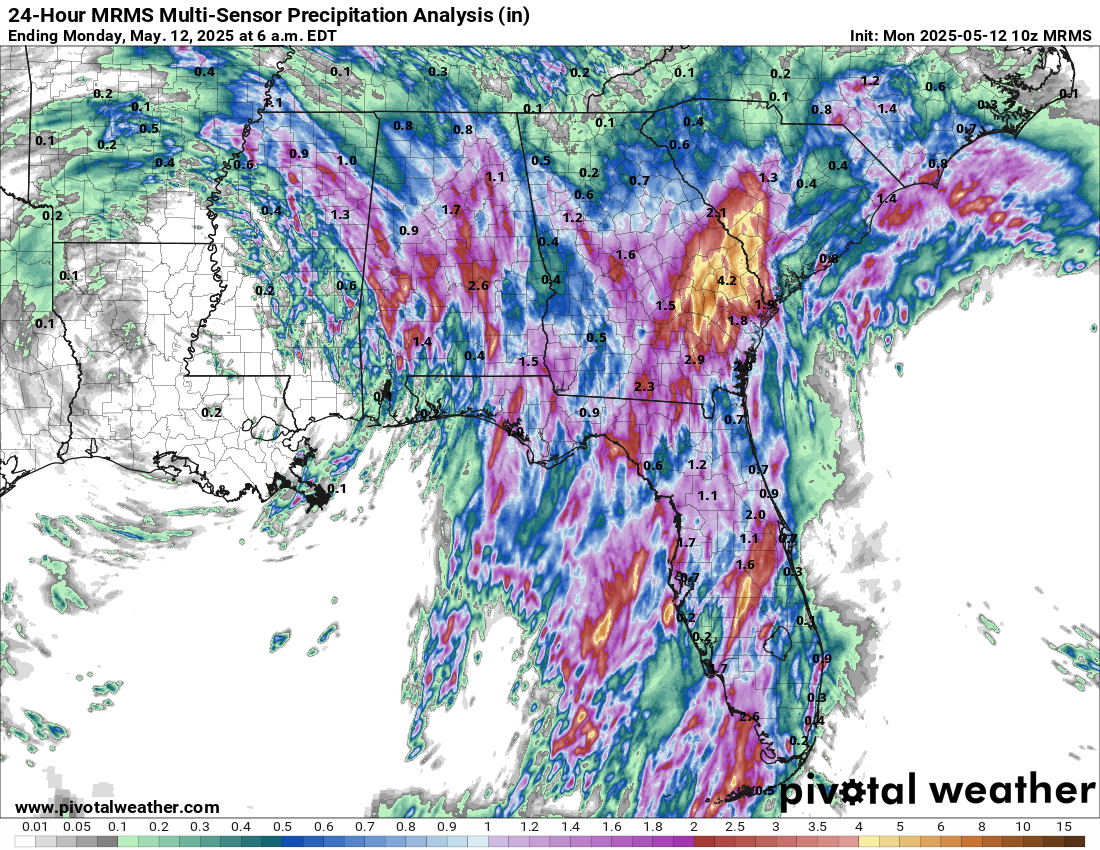
As far as thunderstorms are concerned, we have one more day with the upper level low parked along the Gulf Coast before it starts to finally move off to the northeast tonight into Tuesday. Over the last 24 hours, the heaviest rain fell over parts of eastern Georgia and southern South Carolina where localized amounts greater than 5” fell. Those areas will be most prone for additional flash flood risks if heavy rain producing thunderstorms redevelop over the same spots today. Regardless, all of the Southeast including Florida has at least a slight (level 2 of 4) risk of flash flooding today as waves of storms continue to move across the region.

As far as severe weather is concerned, yesterday was a very active day from northern Utah into Montana and southwest North Dakota. More than 100 reports of severe wind gusts or wind damage were received including seven reports of measured gusts of 75 mph or greater.

Today should be a less active day on the severe weather front, with marginal risks (level 1 of 5) in the Southeast with our slow moving upper low and in Montana with the organizing western storm system.
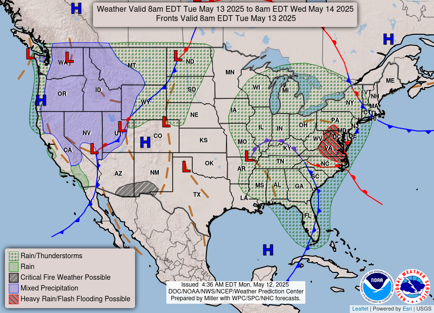
Headed into Tuesday, the Southeast US system will start to move more deliberately northeast toward exiting the coast, with heavy rainfall and flash flooding a risk in the Mid-Atlantic region. In the west, heavy high elevation snows that are ongoing today will continue into tomorrow as the storm system there continues to gradually intensify and move east.

As that storm system starts to head into the Midwest and encounter moisture and instability coming north from the Gulf, the threat of severe weather should start to increase in the northern Plains on Wednesday and then peak on Thursday in the Great Lakes region. Thursday looks as if it could be a rather significant severe weather day, so we will be talking more about that as the week goes on. The cold front associated with that system should become very slow moving from the southern Plains into the eastern United States into the weekend and be the focus for waves of thunderstorms, some of which could be severe.
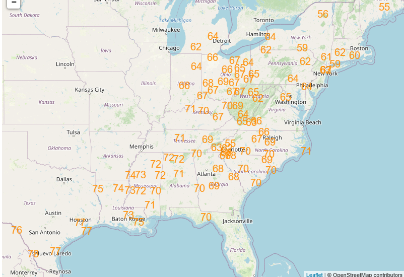
As I mentioned above, south and east of that front near record warmth will be in place. The map above shows the record warm minimums forecast for Friday morning, which should be the peak of the warmth, but near or above record temperatures will continue across the Southeast through the weekend. Rather than post all of the graphics, I am going to encourage you to check out the Weather Prediction Center’s forecast record temperatures site.

Leave a comment