And a more active severe weather pattern on the horizon
When meteorologists talk about record warmth, the conversation (and media) generally focuses on record high temperatures because those are the attention grabbing numbers and people are generally doing outdoor activities during daylight hours. Record high minimums really should be at least as much of a story though for a few reasons. First, they are a significant societal impact during heat waves, because warm minimum temperatures exacerbate the effects of a heat wave by reducing cooling relief at night and keeping structures without air conditioning from cooling during the overnight.
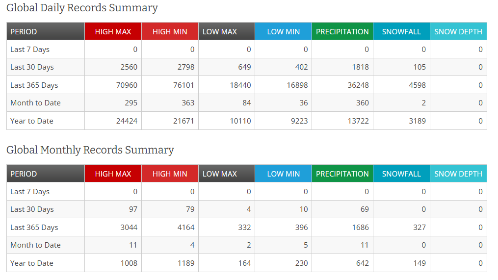
Secondly, the rate of record warm minimums is likely increasing a bit more quickly than record high temperatures. As you can see in this National Centers for Environmental Information table, in the last year global record high minimums are outpacing global record high maximums – and they both far outpace record cold temperatures.
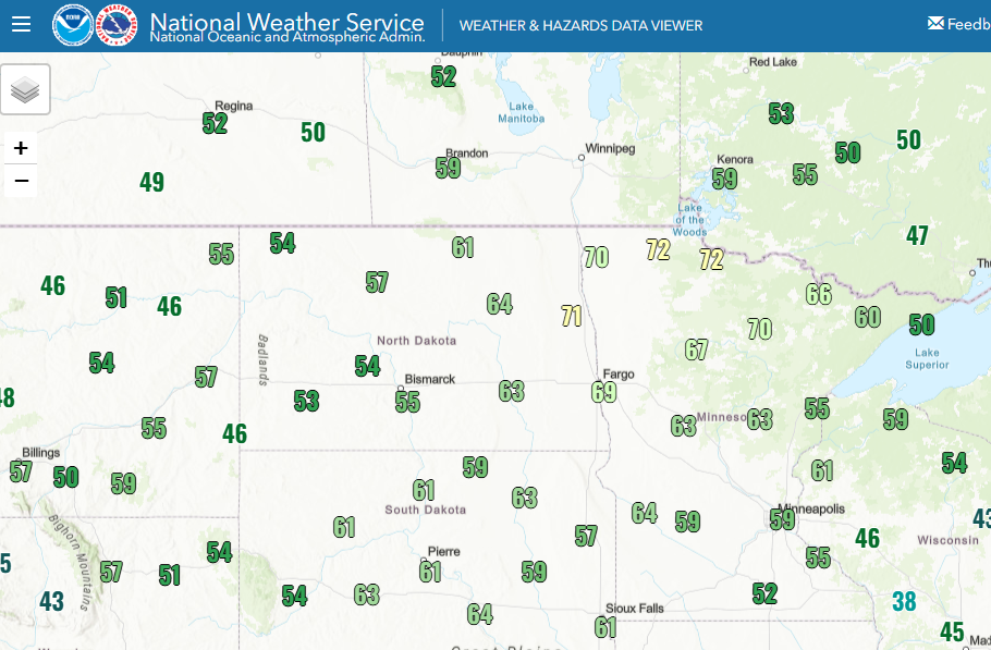
So with that context, let’s turn to the remarkable climate event occurring in the upper Midwest. We talked in yesterday’s newsletter about the record warmth in this region, including International Falls reaching 96F on Sunday, not only breaking their daily record high by 13 degrees but setting a new May record and warmest temperature so early in the season. The graphic above shows the low temperatures on Monday following up on that record warm day. You can see widespread 50s and 60s across the region, with an area of lower 70s in eastern North Dakota and northwest Minnesota.
For people like me who have lived in the South for decades, these sorts of low temperatures do not seem unusual. However, these are unusually warm low temperatures for this part of the country at any time of year, and lows in the 70s in this region is literally off the charts for May. As an example, International Falls, which has climate records dating back to 1895, has only recorded low temperatures of 70F or above on 38 days in the total of its climate record. With a low of 70F on Monday, International Falls broke the record for earliest 70 degree low temperature by more than a month, the prior record being June 17th in 2020. It broke the daily record high minimum by 15 degrees and the monthly record high minimum by 4 degrees. Before yesterday, the top 10 warmest low temperatures in International Falls in May had all come after the 19th.
The adjacent portions of Canada are setting similar records…
These events are what are called “tail events” in climate, extreme occurrences way outside of the norm. The 2021 Pacific Northwest heatwave is another good example of a tail event. They are called that because climate events can be represented by a bell curve, and these events are the ones that are on the far side of the curve. Global warming is increasing the likelihood of tail events on the warm (right) side of the curve for temperature events.
Part of the reason I wanted to spend some time highlighting this today is, first, to bring more attention to these increasing tail events and raise awareness that a tail event in the middle of summer would be much more impactful to society. Secondly, what really strikes me about this event is that the weather pattern to me at least does not have the typical signs that would make me think of a tail climate event. It is certainly warm pattern for the upper Midwest – but it almost seems as if the extreme warmth is just because the air is insanely warm rather than some anomaly I could point to on a weather map. I have actually talked to a few colleagues about this because it just strikes me as unusual – and in some ways concerning.
Whatever the exact meteorological reason, record warmth is going to continue for the next week across parts of the country, first in the north central states and Texas today, and then shifting and expanding east and south.
Again, I am not going to try post all of the daily record graphics (you can view them here), but with this graphic highlight the NWS forecast low temperatures that are above the record warm minimums for Friday. It is an incredibly expansive region. Much of the east and south will see well above normal temperatures through this weekend, while some cooler air will be in the West and moving into the upper Midwest and Great Lakes region later in the week.
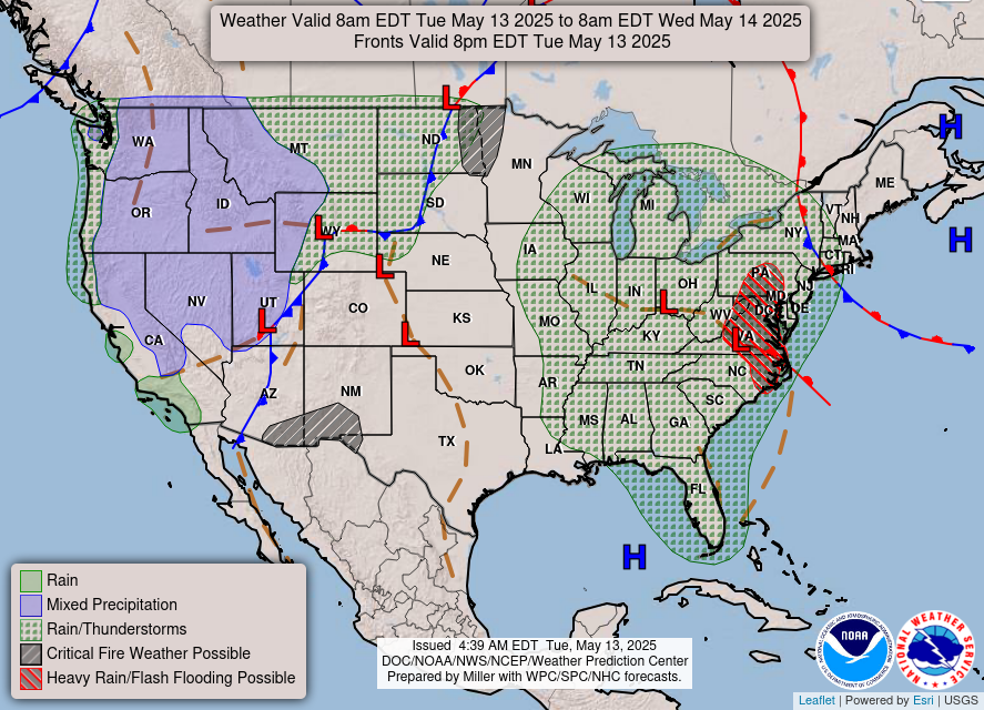
I have spent a lot of time talking about this climate event due to its rarity, but I need to also talk about the sensible weather which will become more impactful as we go through the week. For today, the upper low that has been plaguing the Southeast for days is finally moving northeast; it will bring rain and storms to the East Coast today, including a risk for flash flooding in the mid-Atlantic ,before it finally moves offshore. Meanwhile, in the West, an intensifying storm system will bring rain and high elevation snow to the region.
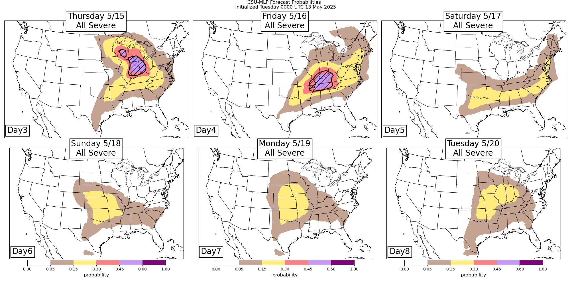
As the storm system in the West moves east, it will bring an increasing risk of severe storms to the Midwest, Great Lakes and Ohio Valley regions Thursday and Friday. These days both look as if they could be higher end severe weather days, will discuss more on this as the week goes on. By Saturday the front associated with that system will stall out from the Southern Plains to the mid-Atlantic region, before a new system coming out of the Southwest brings additional severe weather chances to the middle part of the country early next week.

Leave a comment