At least 5 dead in St. Louis tornado, 700 reports of severe weather so far

Since I will not be doing a newsletter on Saturday, I wanted to take some time to recap what has been a very active day for severe weather from the Mid-Mississippi Valley east to the Mid-Atlantic. As of 10 pm ET, there have been 700 reports of severe weather nationally, mostly in the region from Missouri east to the Mid-Atlantic, but also across northern Texas and parts of the upper Midwest. There have been more than 60 reports of very large hail 2 inches in diameter or larger, and a number of tornadoes.
As we discussed in the morning newsletter, how long the severe storms remained more discrete would determine the magnitude of the tornado risk, and unfortunately the storms remained in that mode long enough for several potentially significant tornadoes to occur across eastern Missouri, southern Illinois, western Kentucky, and southern Indiana.
Likely the most impactful tornado was the one that tracked through the western and northern side of the immediate St. Louis metropolitan area. CNN is reporting this evening that at least 5 people have been killed and initial reports indicate widespread significant damage.
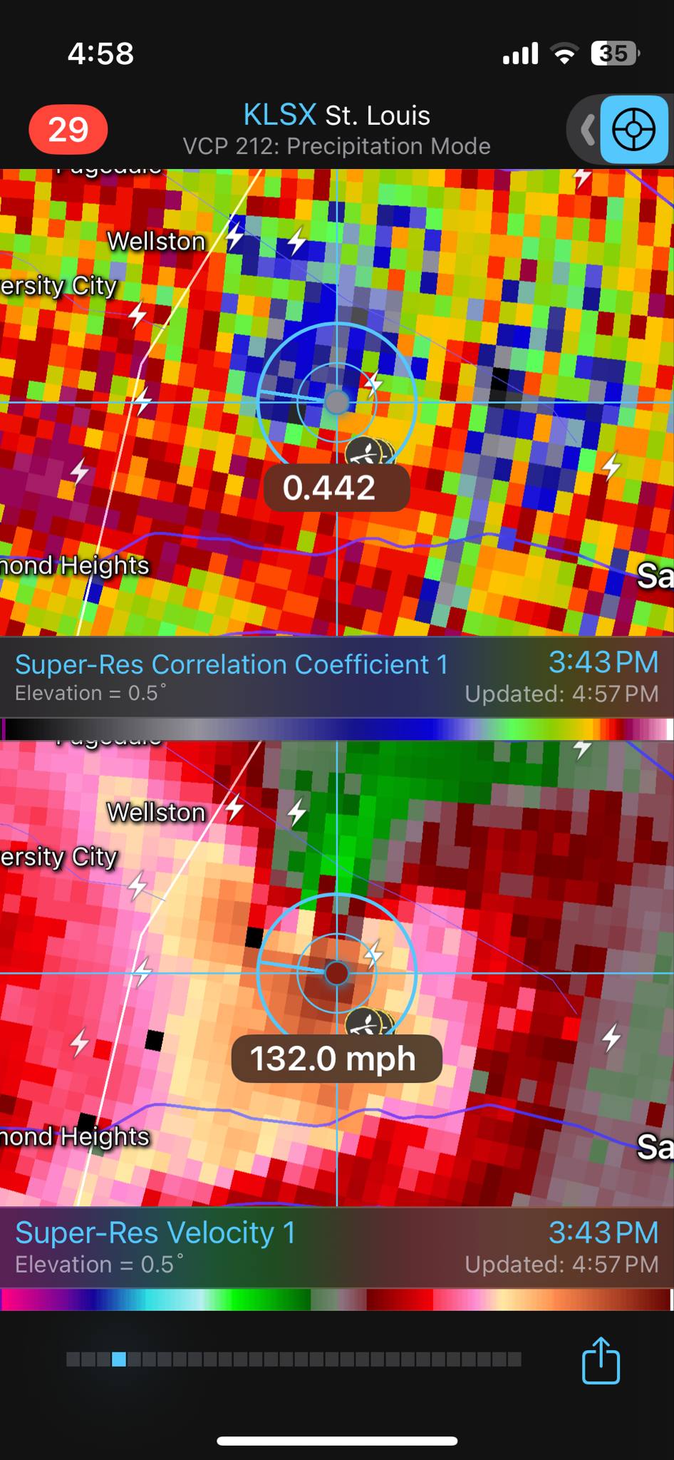
The tornado appears to have initially developed in the Richmond Heights/Clayton area, in the immediate western suburbs of St. Louis, a bit after 3:30 pm CT. By 3:43 pm CT, the St. Louis WSR-88D Doppler radar data as shown above indicated a well developed likely intense tornado on the northwest side of the city of St. Louis, with the radar detecting winds of at least 130 mph (bottom image) and lofted tornadic debris (the blue and grey data southeast of Wellston).
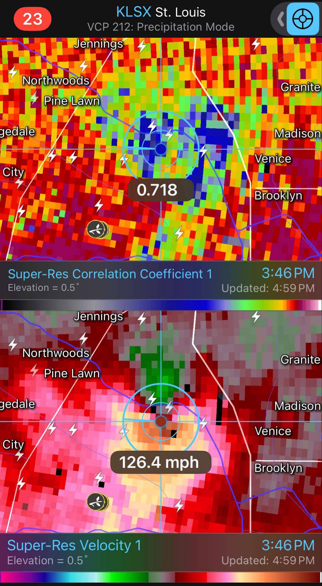
By 3:46 pm, the rapidly moving tornado was approaching the Mississippi River, with radar still detecting greater than 125 mph winds (bottom) and a large debris field from the tornado (areas of blue data west of Madison and Venice in the top image).
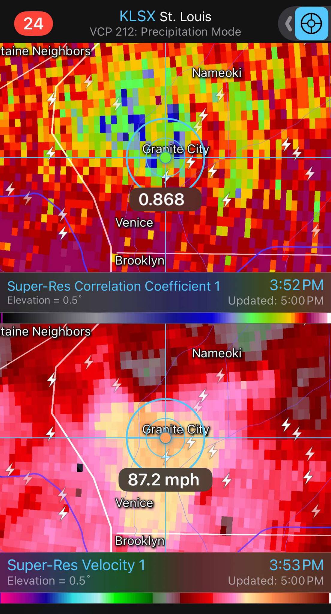
By 3:53 pm, the tornado was likely beginning to occlude – become choked off by colder air coming out of the storm’s downdraft – just north of Granite City, IL, as the velocity data above showed the rotation becoming weaker. There is less green indicating less wind toward the radar which is west of the storm near Weldon Spring, MO, which shows the rotation is weakening. However, there is a large area of intense straight line winds approaching 90 mph in the radar data across Granite City and south into Venice. You can also still see debris in the correlation coefficient data above, although it is a less intense and widespread signature than earlier.
Needless to say this was an incredibly impactful tornado that went right through the heart of a major metropolitan area. There were also numerous reports of very large hail and damaging winds as well. More than 100,000 customers are without power in the immediate St. Louis metro area. The NWS will be surveying damage and reporting on it through the weekend.
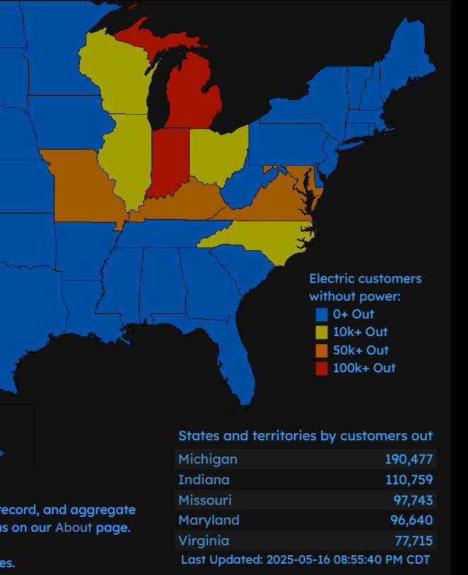
As I mentioned above, significant tornadoes likely also occurred in nearby areas as well. Radar showed signatures of intense tornadoes in western Kentucky and southern Indiana this evening. Several clusters of severe storms from the Midwest to the Mid-Atlantic have left more than 500,000 customers without power this evening.


Multiple clusters of severe thunderstorms continue late this evening from the Ohio Valley southwest to northeast Texas. The Storm Prediction Center continues to have a large area of enhanced to moderate (level 3 to 4 of 5) outlooked for the Ohio Valley and Mid-South regions overnight, with slight risk southwest into the Arklatex region.

Saturday still looks as if it will be a “quieter” severe weather day, but there will still be slight risks of severe storms over the Northeast and the south central states.
Programming Note: As I have mentioned in earlier posts, I am in Florida participate in a charity event to raise money for the Make-a-Wish Foundation of Central and Northern Florida. Because of that, there will not be a regular newsletter on Saturday; however, if and when I see updates about severe weather damage assessments and impacts, I will share as I can.

Leave a comment