And some perspective on NWS staffing in the wake of Friday’s tornadoes
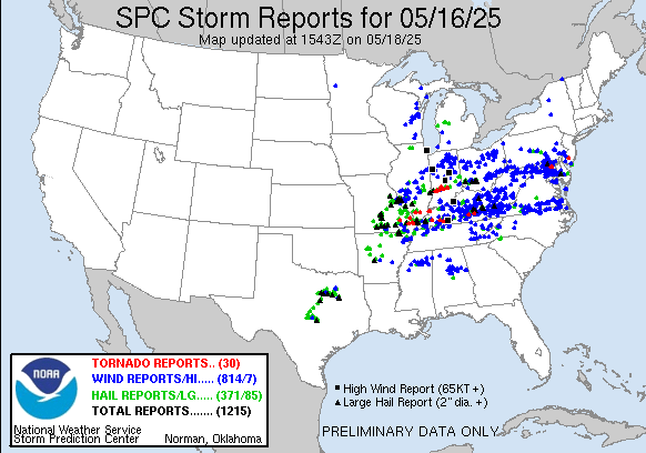
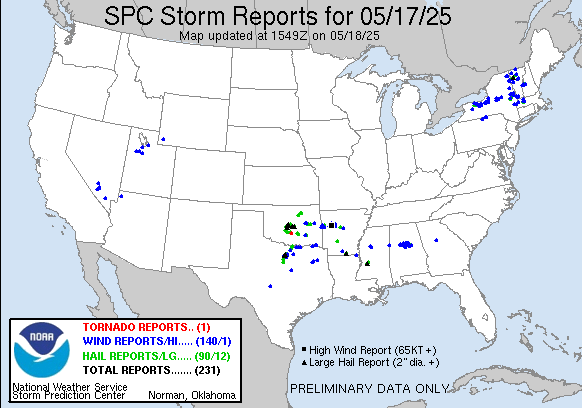
Since there was no newsletter yesterday, I want to start off by recapping the last 48 hours of severe weather. Needless to say, Friday into Friday night ended up being one of the more impactful 24 hour periods of severe weather in the last couple of years, with more than 1200 reports of severe weather that included nearly 100 reports of very large hail 2” in diameter or greater and a number of significant tornadoes. After I recapped Friday afternoon’s tornadoes including the St. Louis tornado – which has been preliminarily rated an EF3 by NWS that was nearly a mile wide at times – an additional long track killer tornado occurred in southeast Kentucky in the vicinity of the city of London Friday night. While exact totals have varied in media reports, as of now the Associated Press is reporting that 18 people were killed by this tornado, with a total of 27 fatalities from the severe weather outbreak.
A lot of social media and news coverage since the southeast Kentucky tornado has focused on the staffing of the Jackson, KY office with warning responsibility for this area, as this is one of several offices that has had to stop doing 24/7 operations and be closed part of each day. As I pointed out on BlueSky, this severe weather episode was well anticipated and there was no way the NWS office in Jackson was not going to have staffing in place for warning operations. This was confirmed by the NWS union to USA Today who stated that warnings were not negatively impacted for the office during the tornado event. While this almost surely true, given that the event was well anticipated it is also not surprising.
What would concern me more as a former NWS meteorologist-in-charge is other potential impacts to staff and services. In the immediate aftermath, I would be concerned about how chronic understaffing might be worsening the fatigue and stress that an NWS office staff deals with after a major fatality weather event, and also about the capacity for the staff to be able to conduct the extensive damage assessments needed after an event of this magnitude. Looking at operations during the event, while warning services were unlikely negatively impacted, I would want to know if the staff was able to perform decision services they ordinarily do during events of this magnitude like emergency management briefings, information sharing with core partners using the NWSChat software, etc? Furthermore, will the office even be able to conduct a full post-event evaluation of operations and services to identify any potential shortfalls such as this and determine potential improvements?
These questions get to issues that go beyond just “were the warnings issued” and touch on impacts that will gradually cause erosion of NWS services, especially as they accumulate over time and over multiple offices across the country. Another important point to consider is that not all impactful severe weather events are this well anticipated, and not all impactful events that NWS offices deal with are even weather events. For example, local NWS offices provide critical support during hazardous material spill incidents which obviously are completely unpredictable. What will the impact of part time offices be when the sort of events occur that cannot be anticipated in advance? These are topics I will be discussing more in future newsletters.

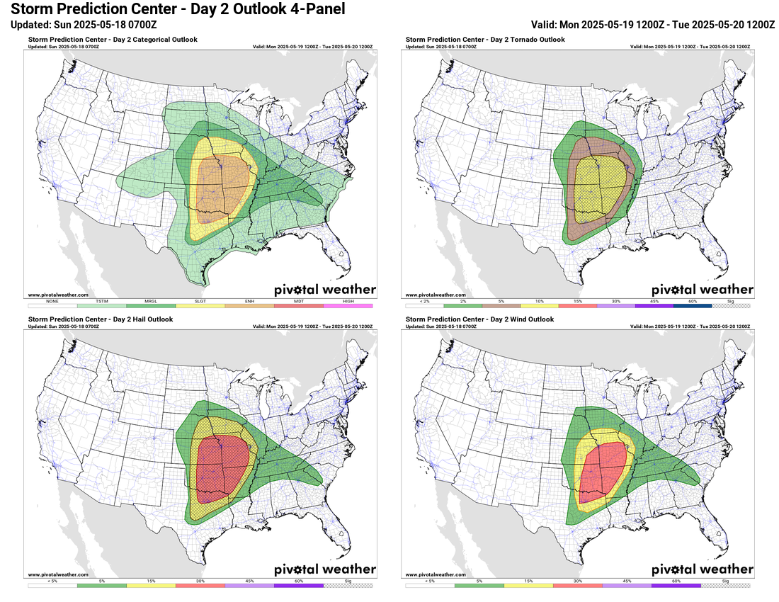
Unfortunately, the weather will be staying very active over the next couple of days as a slow moving, strong storm system comes out of the western United States. Several waves of intense severe storms are expected across the central part of the country during the next 48 hours as this system moves northeast and interacts with very moist and unstable air across the region. The Storm Prediction Center has a moderate (level 4 of 5) risk of severe storms for parts of central Kansas and northern Oklahoma today where several supercell storms capable of giant hail and intense tornadoes are possible. Additional scattered severe storms with very large hail, damaging wind and tornadoes are possible both north and south of the moderate risk; these storms will gradually spread east with time.
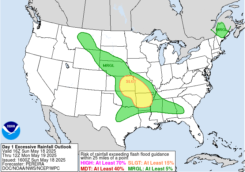
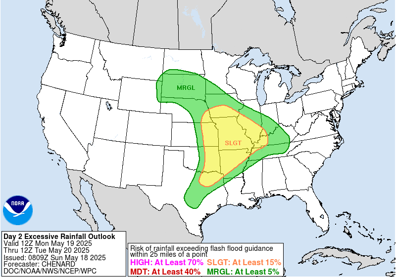
In addition to the severe weather risk, these thunderstorms will produce torrential downpours of rain, and localized flash flooding will be possible as well. Accordingly, the Weather Prediction Center has slight (level 2 of 4) risks of flash flooding in place as seen above.
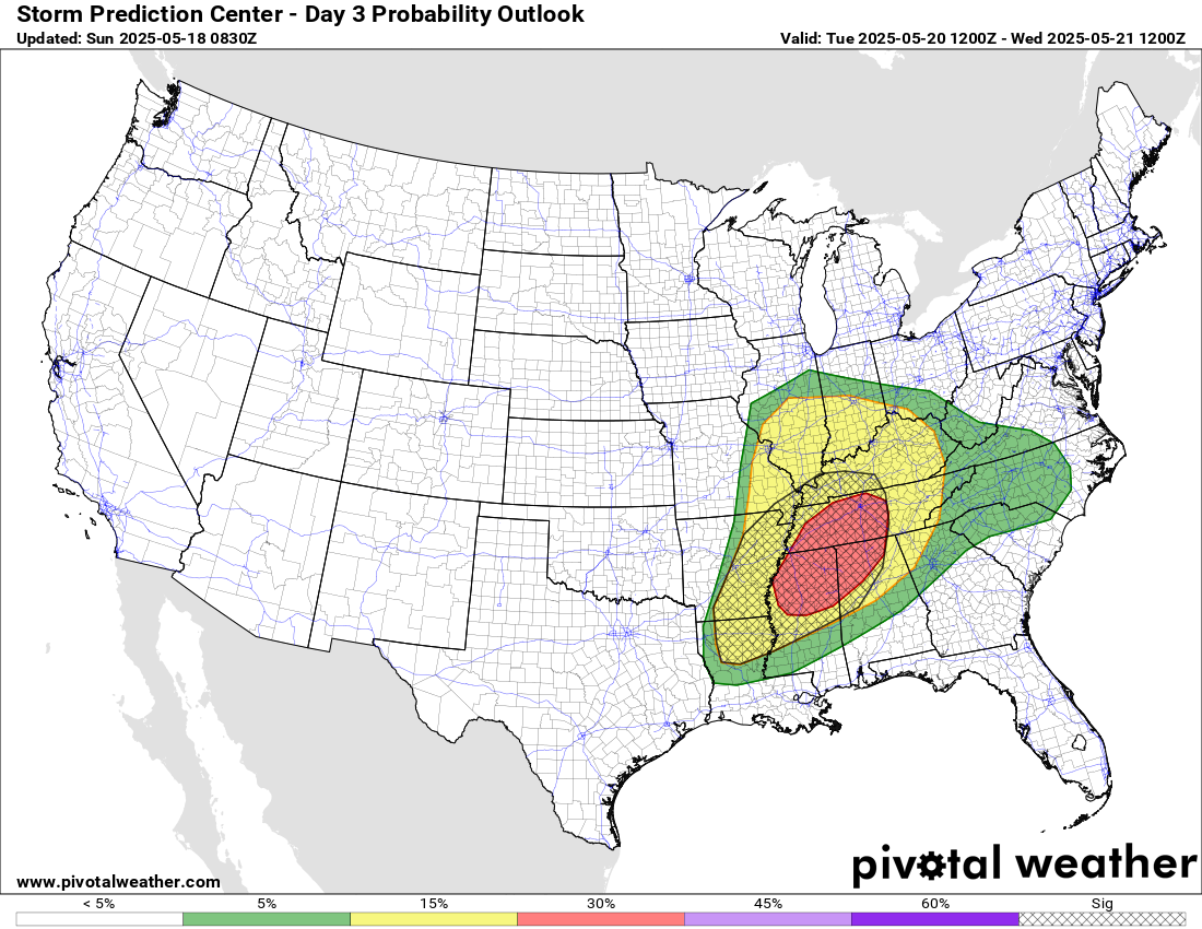

Tuesday will be yet another active day of severe weather, with the potential for additional significant severe storms in the Mid-South and lower Mississippi Valley as the storm system moves farther east. Additional rounds of heavy rain could result in flash flooding across the Mid-Mississippi and Ohio Valley regions.
Beyond the middle of the week, the overall weather pattern should become less active as a large upper level trough of low pressure develops over the eastern United States, resulting in a less favorable pattern for severe weather for much of the country.

Leave a comment