And talking about the online weather communication environment
Good morning! I am back at my home base in Oklahoma after a week in Florida – so expect more posts and discussion about all that has been happening in the weather world the last several days. I want to start off this morning by highlighting a Substack article posted last night by my friend and colleague Matt Lanza about how online weather communicators are becoming a more important part of the way in which the public receives severe weather information. This overall trend has been bemoaned by many in the professional weather community as some of these online weather accounts are run by non-degreed individuals and rely on a lot of hype to attract audiences.
However, Matt points out that after watching a number of these accounts during the recent severe weather that when you get past the hyped up ads, some of these sites do a pretty job of communicating in a reasonable, scientific manner. Obviously, many of them are effective in connecting with the public as they have large, dedicated audiences. Ultimately, the goal of the weather community should be to get people the weather information they need when they need it, and it seems clear to me that we at a minimum need to have a conversation about what these online entities are doing that is helping them connect with the public. I started Balanced Weather in part because I hoped to bring a more balanced (ha) and scientific approach to communicating weather and climate information, and I definitely have serious concerns about the “wild West” internet and social media landscape and the fact that the public is left having to try to sort out the wheat from the chaff. I appreciate that Matt is using his platform to make some provocative points about these issues that will hopefully further the conversation about these topics; I hope you’ll take the time to read his article, and if you have thoughts share them in the comments (I have turned comments on for everyone for today’s newsletter).
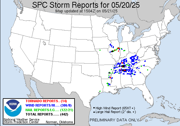
Getting back to the actual weather, Tuesday was yet another active day as we closed out yet another multi-day period of very intense severe weather. Over 400 reports of severe weather were received by the Storm Prediction Center (SPC), including more than 20 reports of very large (2” or greater) hail and several tornadoes. Tornadoes caused damage to homes and buildings in Madison, AL (suburb of Huntsville) and near Clarksville, TN.
While obviously a lot of damage assessment is still ongoing, there appear to have been at least 80 tornadoes since last Thursday. The most impactful part of the event overall was Friday afternoon into Friday night, with two violent tornadoes (southern Illinois and southeast Kentucky) and a large EF3 tornado that went through the heart of the St. Louis metro area including northern and western parts of the city of St. Louis. At least 27 people lost their lives during the Friday into Friday night tornado sequence with dozens more injured. Very large hail also impacted numerous areas over the last several days. A variety of preliminary insurance industry estimates suggest this period of severe weather was the most damaging of the year so far with more than $10B in damage.
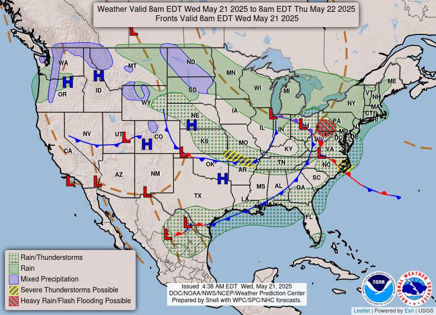
As we have been discussing the last few days, today will be less active than we have seen the last week or so, although there will still be some areas of concern. The storm system that produced the severe weather yesterday will continue to advance slowly east today, resulting in showers and storms along the East Coast. A few severe storms will be possible, with the greatest risk in coastal North Carolina where SPC has a slight (level 2 of 5) risk in place. A band of strong storms should develop along the advancing front in eastern Ohio and western Pennsylvania this afternoon and evening, potentially causing some localized flash flooding and a few reports of severe weather. Finally, some scattered strong to severe storms could develop tonight across the Ozarks as a disturbance in the northwest flow aloft on the backside of this storms moves southeast, with large hail being the primary risk.

This morning’s weather models suggest that the weather setup that could produce severe storms over the Ozarks tonight will shift southwest and potentially produce additional severe storms across parts of Oklahoma and northern Texas on Thursday, with large hail again the primary severe weather risk but also some potential for damaging downburst winds.

As we go into the Memorial Day weekend, a nearly stationary front will become established from the central Rockies through the Mid-South and then southeast toward the Gulf Coast. Disturbances moving through the upper level flow along this front will result in several waves of thunderstorms. Given an increasingly unstable atmosphere and decent wind shear, some of these storms could be severe especially on Saturday and Sunday as shown in the CSU-MLP probabilities above.
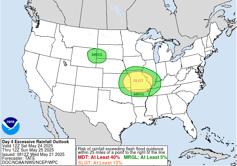

Given repeated rounds of storms producing heavy rainfall, flash flooding will also be a concern, and WPC has slight (level 2 of 3) risks of excessive rainfall in place for this weekend.
Beyond Monday, the front should be pushed south into the Gulf, resulting in a more sustained period of quieter (and cooler) weather for much of the eastern two-thirds of the country next week.

Leave a comment