NSF ICECHIP teams study the storms. Also record heat possible in the West by the weekend.
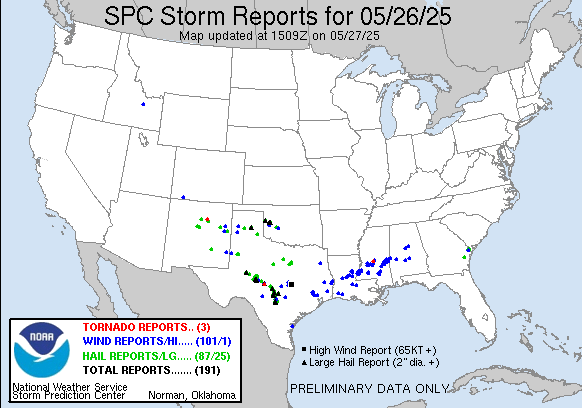
Good Tuesday morning, and welcome to a new and abbreviated work week. Memorial Day saw quite a bit of severe weather yet again from the Southern Plains to the Southeast, and very large hail was again a big story in Texas and Oklahoma with more than two dozen reports of 2” or greater hail received by SPC.
Several intense severe storms developed over the Hill Country of central Texas, with one directly impacting the city of Fredericksburg with multiple reports of hail up to tennis ball sized.
The atmosphere continued to provide plenty of data for ICECHIP, a National Science Foundation (NSF) supported field project to comprehensively study hail producing storms in the Plains. On Monday, ICECHIP teams documented a couple of very large hail producing storms, including storm near Menard, TX that produced hail nearly 6” in diameter (lower right hand picture). The ICECHIP teams are using a variety of remote sensing and specialized instrumentation to study these storms to better understand how large hail forms, its impacts and how we can better detect and forecast it. Unfortunately, I am compelled to mention here that proposed cuts and reorganization activities at NSF could imperil projects like ICECHIP going forward.
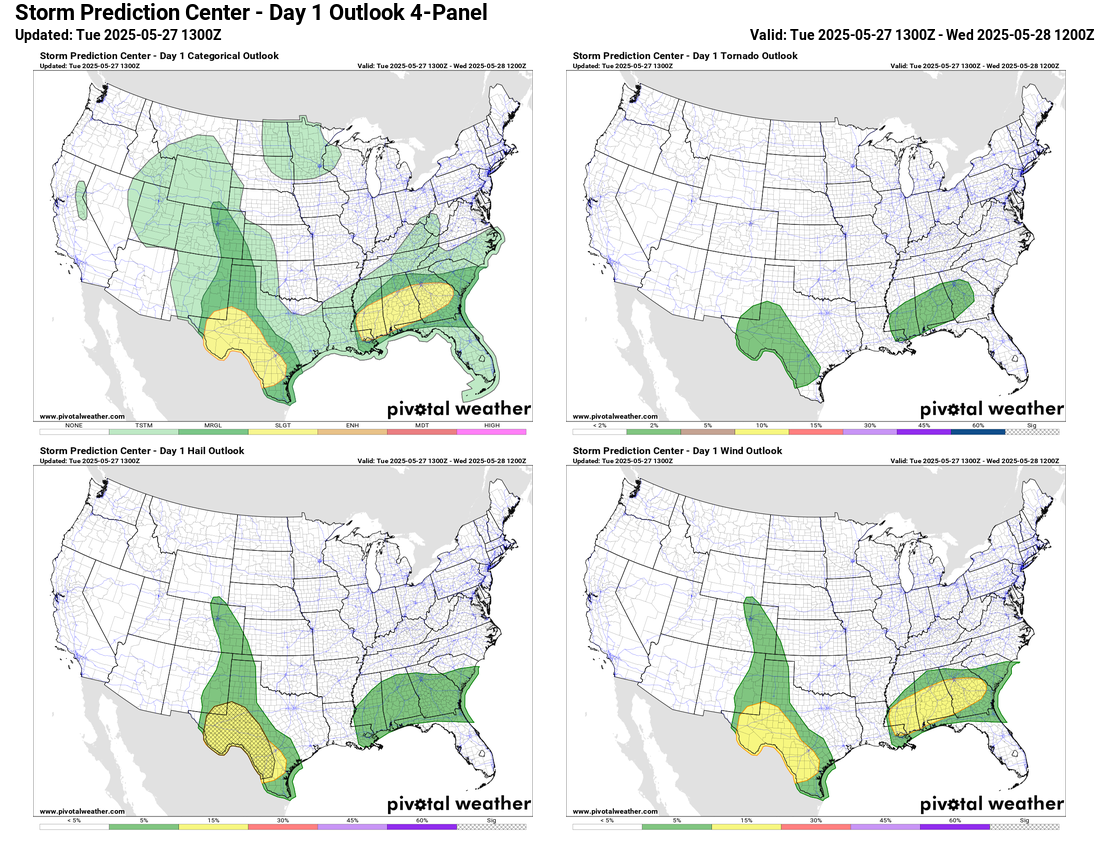
Today’s severe weather risk looks to be focused in two main areas. Over the Southeast, eastward propagating bands of thunderstorms will have a risk primarily of producing damaging downburst winds, while over Texas clusters of severe storms this afternoon and evening will be capable of producing very large hail, damaging winds and possibly a few tornadoes.F
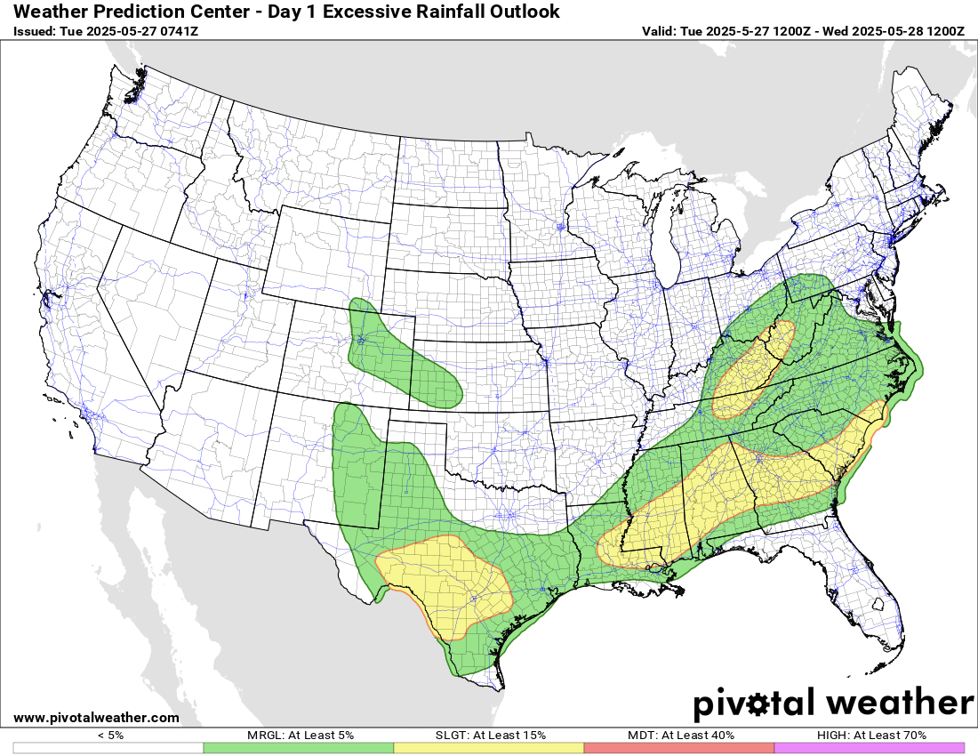
Flash flooding will also be a risk today in these same areas. Slow moving thunderstorms over the terrain of the central Appalachians could cause some flash flooding in that region as well.
The slow moving front that has been responsible for focusing thunderstorm activity the last several days will become almost stationary on Wednesday and Thursday from the central Plains to along the Gulf Coast region. Clusters of thunderstorms will continue along it with some risk for large hail and damaging winds from the most intense storms.
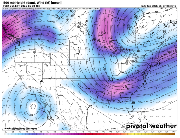
As we head toward the end of the week, the upper level weather pattern across the country will begin to become more amplified, with large trough of low pressure developing over the eastern United States while a high pressure ridge evolves over the West. A rather intense upper level system digging into the Southeast on Friday will help spur the development of this pattern, and the corresponding development of a low pressure system at the surface will bring a more organized risk of severe storms to this region Friday afternoon and evening.

There are still some rather large differences amongst the various models on the strength and track of this storm system which will impact the magnitude of the severe weather risk and how far north into the Mid-Atlantic it will spread. As of now, it looks as if the greatest risk will be in the Carolinas and Georgia as shown in the SPC day 4 outlook above.

The strengthening upper level ridge in the West will result in building heat through the end of the week, and by Saturday a number of record high temperatures are possible. Some May monthly records could even be reached on the last day of the month.

Leave a comment