Large hail, flash flooding and 75 mph wind gusts cause significant damage
When meteorologists talk about the seasonal hurricane outlook, we often stress that the forecast numbers do not really mean that much to an individual because “it only takes one” to mess things up for you. The same thing applies to intense supercell severe thunderstorms, and yesterday was a prime example in central Texas. There were only a couple of intense supercells – but unfortunately one of them tracked through the northern side of the Austin metro area at peak intensity.
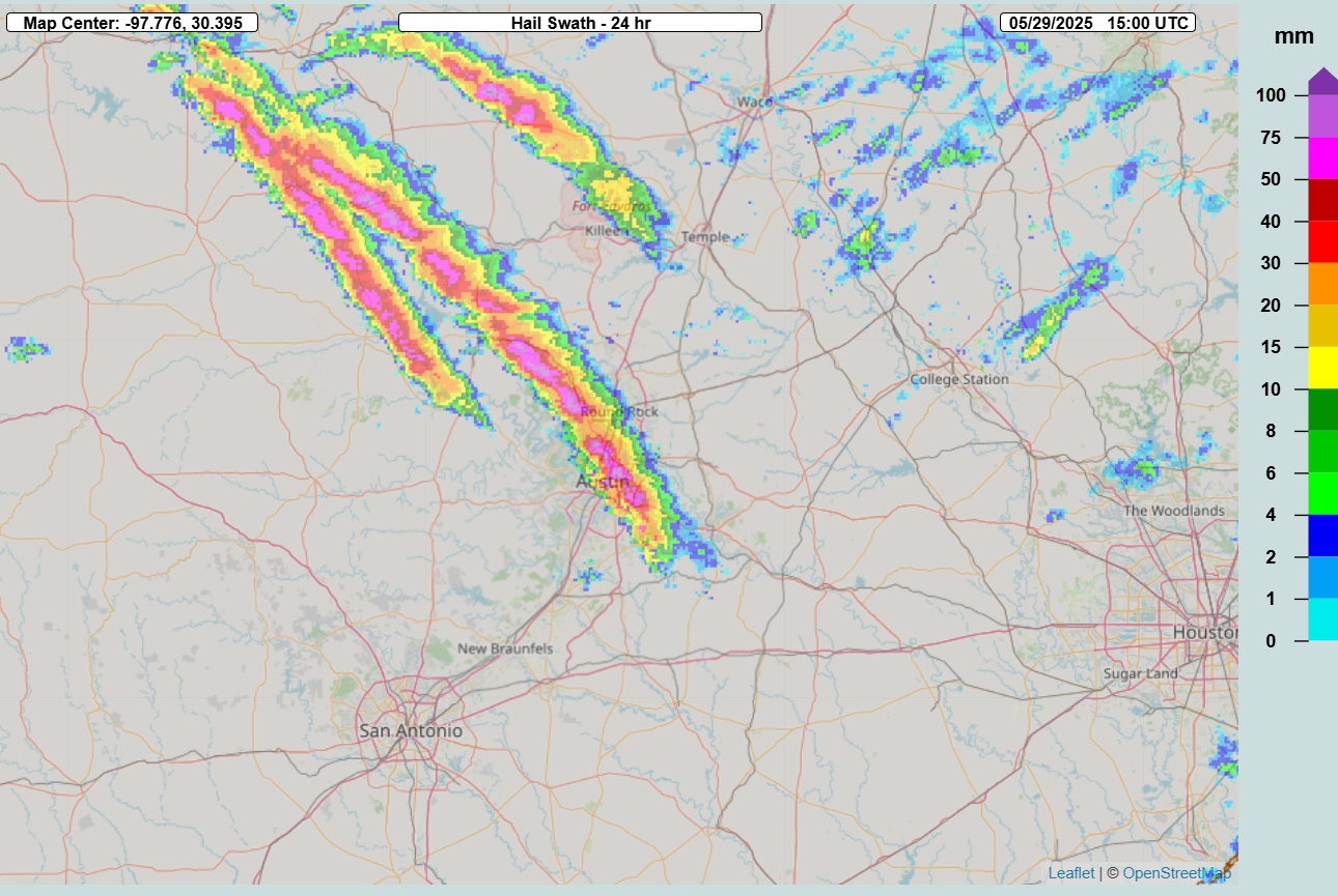
This storm was also an example of how these storms can do a lot of damage without producing significant tornadoes. The MRMS hail swath product above showed hail up to baseball sized with this storm as it moved through the Austin region; a couple of storm chasers reported hail up to that size, and golf ball to hen egg (2”) sized hail definitely seems to have been common along the path of this storm based on mPING and NWS reports. Additionally, the storm produced intense winds with a 77 mph wind gust reported at Austin-Bergstrom Int’l Airport; up to 75,000 customers lost power in the region at the peak of the storm.
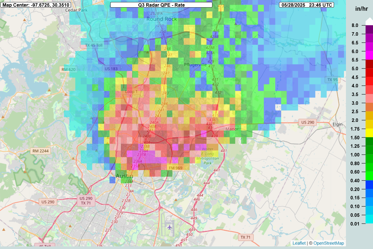
While it was just this one storm, it was moving rather slowly and the MRMS rainfall rate product indicated 5” per hour rainfall rates with the storm.
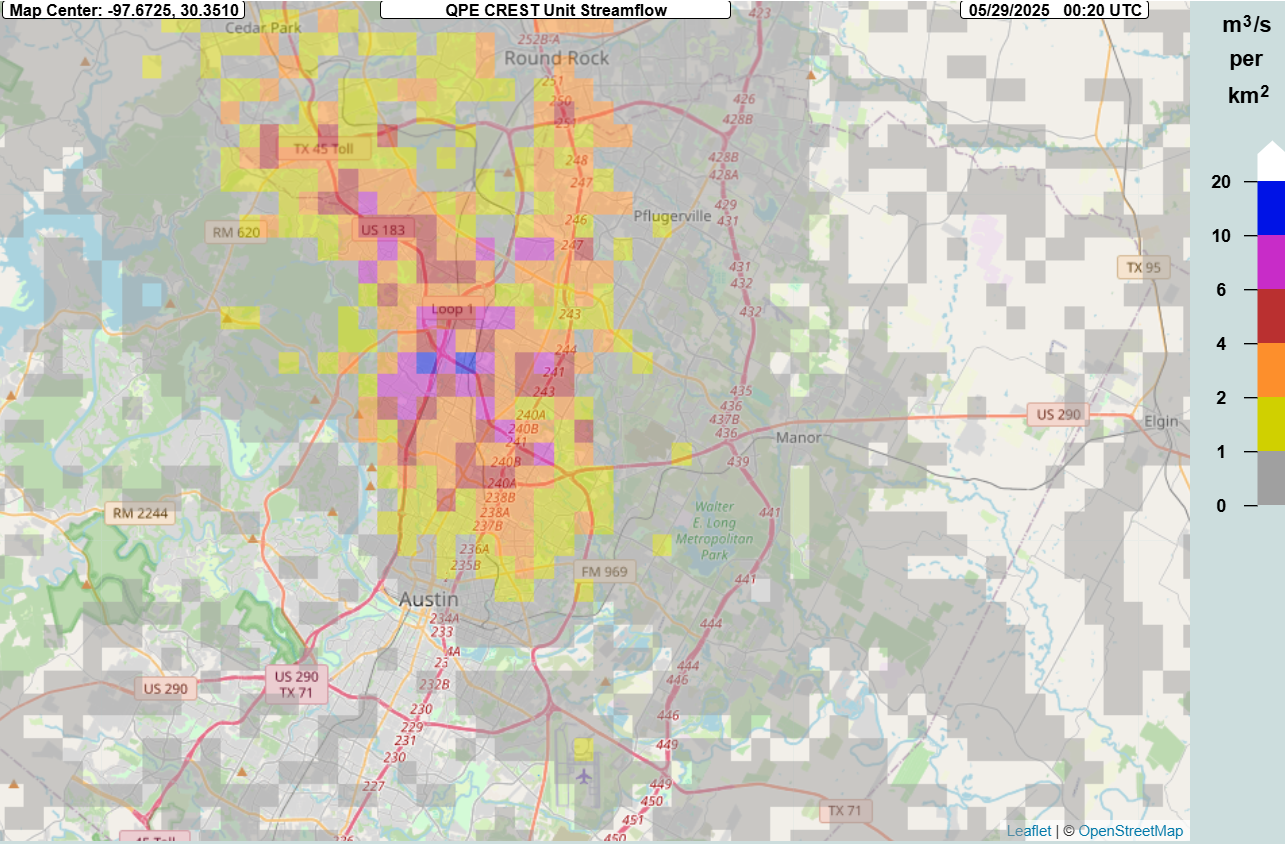
The intense rainfall interacting with the urban environment resulted in significant runoff as shown by the MRMS FLASH unit streamflow product, with values of 10+ indicative of impactful flash flooding. A number of water rescues were reported in the area, and unfortunately one person was killed by flash flooding.
In my opinion, this event is a prime example of how the expanding bullseye effect as discussed by researchers Walker Ashley and Stephen Strader – described here – is dramatically increasing the impact of severe weather regardless of how climate change is impacting the frequency and magnitude of such events. Along with impacting Travis County where Austin is located, this supercell moved through Burnet and Williamson counties just north of Austin. These counties are seeing tremendous growth, with the Texas Demographic Center estimating population increases of 17.1% in Williamson County and 12.6% in Burnet County just in the 2020-4 period. Increasing urban sprawl is placing much more in the way of societal “targets” in the paths of these storms, resulting in increased economic and human tolls.
From an economic perspective, the increasing loss from hail produced by the expanding bullseye effect is of particular concern, given that a 2018 study showed 70% of thunderstorm related damage in the US is caused by large hail. This is a big reason why the scientific community is focusing research efforts on hail such as the ICECHIP project I discussed a couple of days ago. What the economic loss from this storm will end up being is obviously not known yet, but a similar storm in Austin metro area in 2023 resulted in $600M in damage.

Looking at today’s weather, additional supercell thunderstorms will be possible this afternoon and evening across northern and central Texas, with very large hail and a few tornadoes a concern once again. A slight (level 2 of 5) risk of severe storms is in place in this region. An additional slight risk is over coastal South Carolina and Georgia, where severe storms producing damaging downburst winds will be the primary risk.
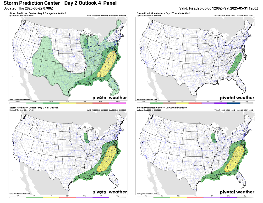
As we go into Friday, the developing upper level weather pattern of a strong trough of low pressure in the East will focus a more organized risk of severe storms from the Mid-Atlantic to the Florida Panhandle. Bands of severe storms moving through this area ahead of a cold front could produce damaging winds, large hail and perhaps a tornado or two.
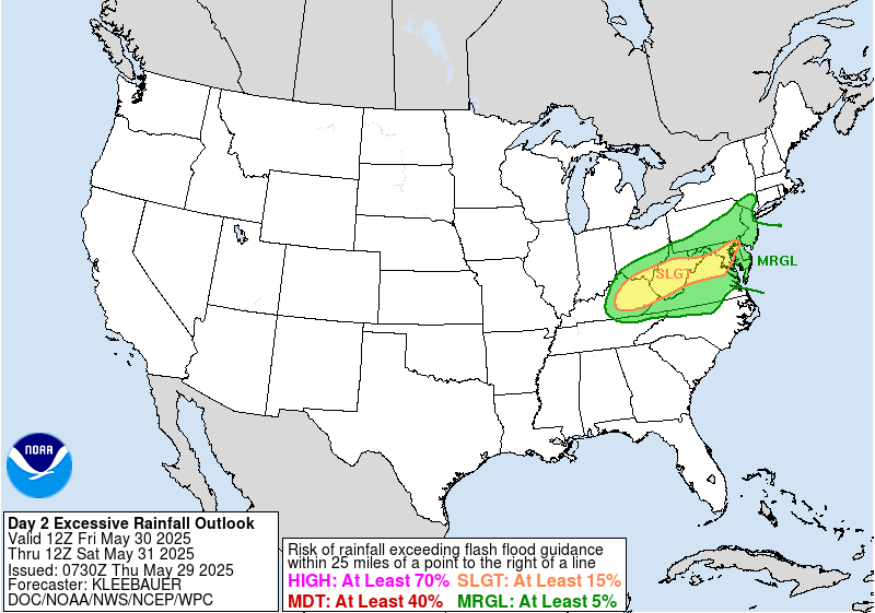
To the north of this area, flash flooding will be of concern from eastern Kentucky across the DC area from repeated rounds of showers and storms producing heavy rainfall.

While the East will be under the cool influence of an upper level trough of low pressure this weekend, the West will see building heat under an upper level ridge of high pressure.


Record warmth is possible through the weekend. A number of record highs expected Saturday including possibly a few monthly records.
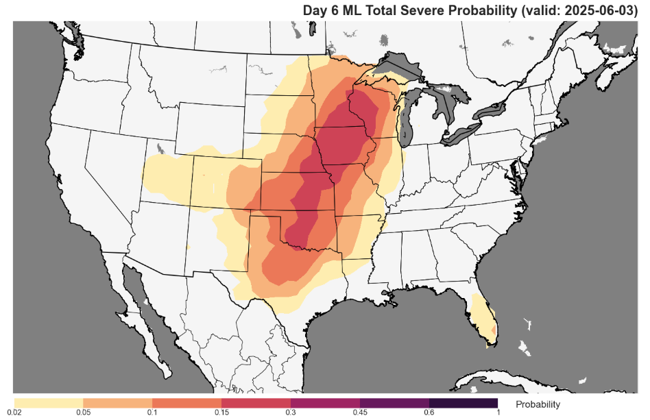
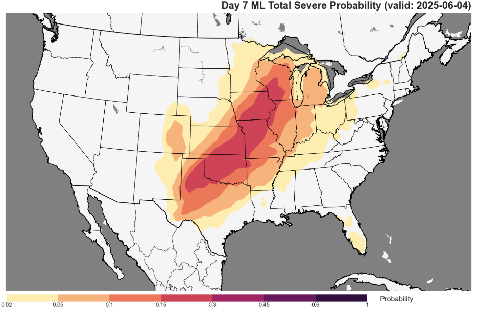
This weather pattern appears as though it will be rather transient, though, as a new upper level trough is expected to develop over the western US by early next week. This should bring the return of severe weather threats to the Plains and Midwest.

Leave a comment