Weekly tropical update June 10
This is my first regular weekly tropical update for Balanced Weather. This will be a bit of a work in progress as I figure out the content and timing that will be optimum. Given that, I would deeply appreciate comments and suggestions – please feel free to provide any input, comments are open to all subscribers below.
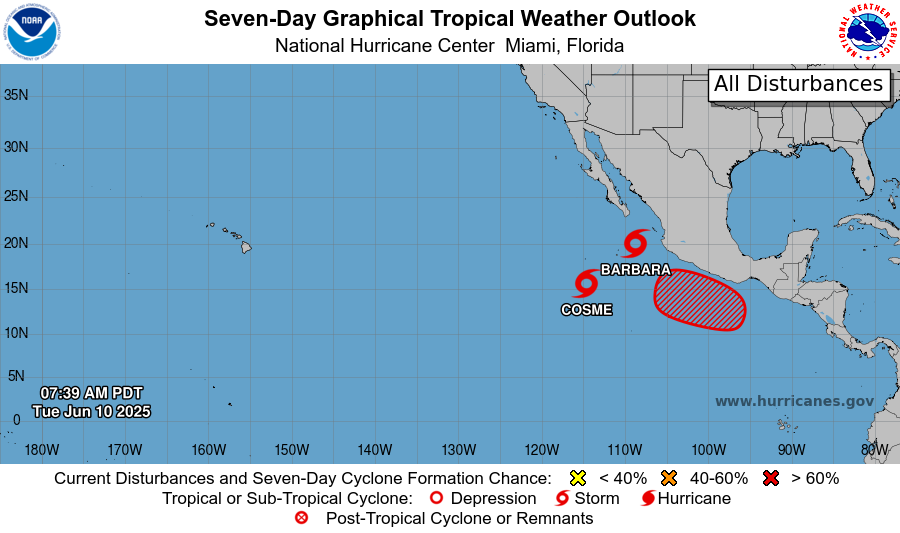
For the first ten days of June, the eastern Pacific has been where the tropical action has been focused, really globally. There have been three eastern Pacific tropical cyclones during this period: Alvin, Barbara, and Cosme. Barbara briefly reached hurricane intensity, but is now weakening along with Cosme, which reached strong tropical storm intensity at its peak. Barbara and Cosme are both anticipated to continue weakening into remnant lows in the next couple of days as they move west.
(A quick aside about the term “tropical cyclone.” Tropical cyclone (TC) is the generic term for any organized low pressure system of tropical origin. Tropical depressions are TCs with sustained winds less than 39 mph; tropical storms are TCs with sustained winds of at least 39 mph, once a storm has sustained winds of 74 mph or greater, it is called a hurricane in the Atlantic or eastern or central Pacific basins.)
Over the next week, the overall favorable conditions for tropical cyclone formation are expected to evolve a bit farther to the east, closer the vicinity of central America. The global models have varied quite a bit over the last week on where and how tropical development might occur with this more favorable environment, with the European model ensemble showing development focused in the eastern Pacific while the American Global Ensemble Forecast System (GEFS) has shown development both in the eastern Pacific and in the western Caribbean or southern Gulf.
In the last day or so, the GEFS has been backing away from showing much development on the Atlantic side, with the consensus now that the eastern Pacific will likely continue to be the focus for development. NHC now has a high (70%) chance of development outlooked in the Gulf of Tehuantepec, with a system likely to form and then move on a track similar to Barbara just offshore of Mexico. The models hint that another system could develop a bit farther southeast in about 7-10 days, closer to the coast of Costa Rica or far southern Mexico.
Looking at the longer term, periods of more active tropical cyclone development are generally modulated by a larger scale tropical disturbance called the Madden-Julian Oscillation (MJO). When it is active, the MJO moves eastward around the global tropics with every 30-60 days, enhancing thunderstorm activity and during the tropical cyclone season, enhancing tropical cyclone development.

Meteorologists monitor the progress of the MJO using a phase diagram like the one above (called a Wheeler and Hendon diagram after the scientists who developed the technique). Each dot shows the position and strength of the MJO on a given date, i.e., “9” means June 9th, the MJO is active in the Western Pacific (region 7), and the farther from the center of the diagram the dot is, the stronger the MJO is. So in summary, a rather modest MJO has been progressing through the western Pacific over the last week or two, but is forecast to weaken by the global models and become a limited influence over the next two weeks.
With the lack of a strong MJO influence, anticipating longer term tropical cyclone activity is difficult. Typically in June, most tropical cyclones in the Atlantic develop over the Gulf, northwest Caribbean and off the Southeast US coast. Often times they develop along old frontal systems or from upper level areas of low pressure that stall out and gradually take on more tropical characteristics. Anticipating these types of development are often difficult even at a few days out. Bottom line is that right now there is nothing in the observations or models that suggest any kind of a significant threat in the Atlantic in the next couple of weeks.
What has actually been a bigger story in the Atlantic tropics over the last week has been Saharan dust outbreaks. The Saharan Air Layer (SAL) is a very normal aspect of the Atlantic tropical weather regime from June through early August, with outbreaks of Saharan air typically moving west off of Africa every 3 to 5 days and moving west across the Atlantic. When the overall weather pattern is favorable, this air can be transported as far west as the parts of the southern United States, causing hazy skies and affecting air quality. SAL outbreaks have significant impacts on the weather, as the dusty air is dry and stable and suppresses thunderstorm (and tropical cyclone) development.
Saharan dust outbreaks have already affected Florida over the last week, and with the redevelopment of a large area of high pressure over the southwest Atlantic over the next 7-10 days, additional surges of the SAL into the southern United States are possible. Typically, SAL outbreaks diminish rapidly after early August, but when outbreaks do occur later in the season they negatively affect tropical cyclone development and atypical SAL outbreaks can be a sign of a less active hurricane season. Particularly active SAL periods in June and July can also reduce solar heating in the tropical Atlantic which can affect sea surface temperatures (SSTs) and thus seasonal hurricane activity.
Speaking of seasonal hurricane activity, Colorado State University will issue their early season update to their seasonal forecast tomorrow (June 11), and I will be very interested to see their update. While I do not want to read too much into it, the fact that we have had so much eastern Pacific activity already – and are anticipating at least one more system in the next week – could be a sign that the anticipated below normal eastern Pacific season may be in danger.

A more active eastern Pacific would be a potential positive sign implying a less active Atlantic season. Conversely, SSTs in the main development region (MDR) of the Atlantic basin west of Africa have overall warmed a bit over the last month, which would be somewhat more favorable for Atlantic tropical activity. Bottom line – I look forward to hearing what the experts at CSU have to say tomorrow, and will report back to Balanced Weather readers.
Again, please provide any feedback or ideas about what you would like to see in these weekly tropical newsletters below.

Leave a comment