Heat starts to build into the Midwest and East
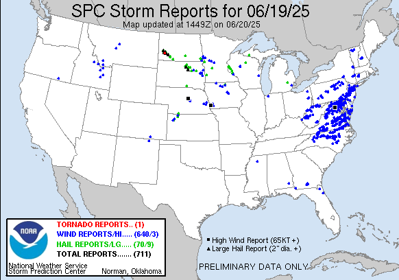
As anticipated, Thursday was a very active day for severe thunderstorms in the East, as a band of severe thunderstorms producing widespread damaging winds swept across the region. Over 500 reports of wind damage and severe winds gusts were received by SPC, with the strongest measured wind gust a 75 mph measured gust at the NWS Field Support Center near Dulles Airport. At the peak last evening, more than 500,000 customers were without power in the region per PowerOutage.US.
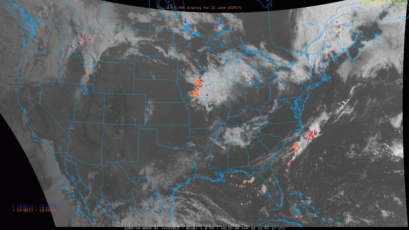
Other scattered severe storms occurred over the upper Midwest on Thursday afternoon and night, and as we head into Friday morning visible satellite imagery with GOES Lightning Mapper data overlaid shows a band of strong storms that organized over this region overnight now dropping south through Iowa. We can also see a rather strong upper level weather disturbance moving through Montana producing scattered thunderstorms. This disturbance will be the focus for intense severe thunderstorm development later today and this evening farther east in a very favorable environment for severe weather.

Strong daytime heating of a very moist airmass south of an east-west warm front across the northern Plains and upper Midwest will result in a very unstable airmass. As the Montana disturbance moves east, several intense supercells should develop and track east with very large hail, damaging wind gusts greater than 75 mph, and strong tornadoes all possible. SPC has an enhanced (level 3 of 5) risk of severe storms in place from extreme eastern Montana eastward across the northern half of Minnesota.

Heading into the weekend, the upper level weather pattern of a trough along the west coast and a downstream building area of strong high pressure will become established. For Saturday, the threat of severe weather looks to be focused over the Great Lakes region.
In the Southwest, monsoon moisture began moving into New Mexico on Thursday, feeding thunderstorms that produced burn scar flash flooding near Ruidoso. The monsoon moisture will increase this weekend and into early next week on the back side of the strong heat dome over the East, with an increasing flash flood and debris flow risk in New Mexico.
Elsewhere across the Southwest and Intermountain West, Thursday was a hot day with a number of record high temperatures set, including Salt Lake City at 104F, breaking an 85 year old record (101F in 1940). Phoenix hit 117F which was a degree shy of the 118F record last set in 2017.
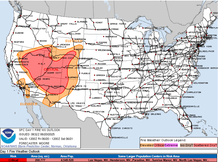
As the upper level trough develops over the west the next couple of days, the heat will begin to subside over this region, but increasing winds and dry conditions will result in increased fire danger over a wide area today and Saturday. Red Flag Warnings are in effect across much of Nevada, Utah, western Colorado, northern Arizona and northwest New Mexico.
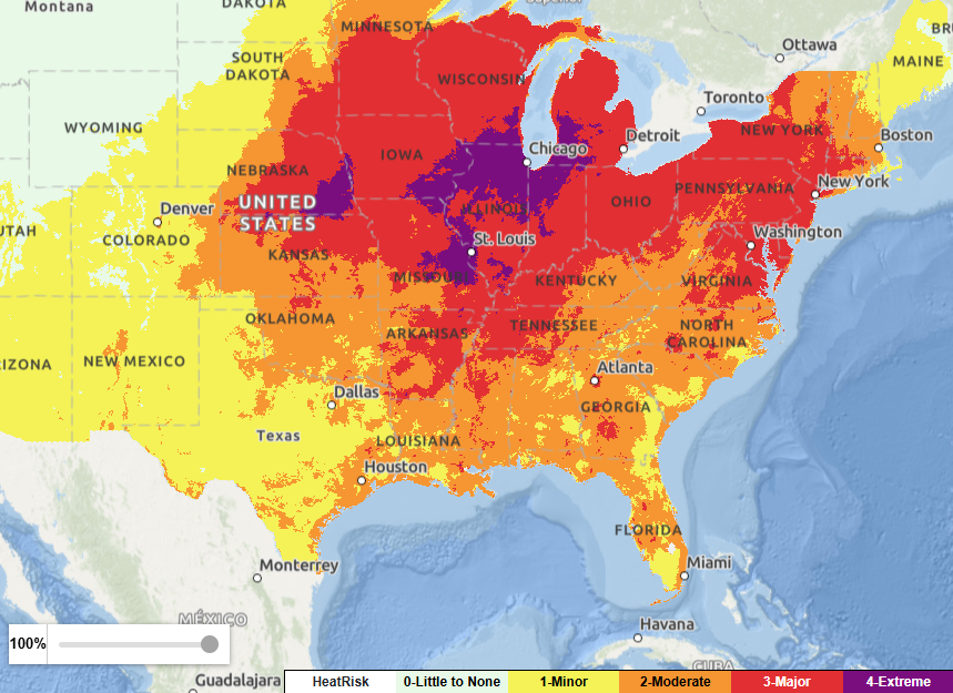
The dominant weather story heading into next week will be the building heatwave across the eastern half of the country. By Sunday, the combination of near record temperatures and oppressive humidity will result in widespread major to extreme heat risk, with extreme heat risk anticipated in major metro areas Chicago and St. Louis.
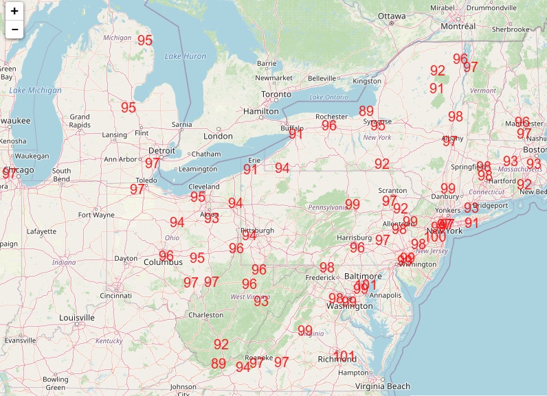
By Monday and Tuesday, the upper level high pressure system over the East will reach peak intensity, and numerous record warm temperatures – both record maximums as shown above for Monday and record warm minimums – are anticipated across the northeast quarter of the country.

When combined with oppressive humidity, widespread extreme heat risk is expected Monday and Tuesday (Tuesday shown above), including much of Ohio and building into the Mid-Atlantic region including the DC metro area.
While the upper level high pressure will start to weaken after Tuesday, it is expected to remain relatively strong and centered over the Mid-Atlantic region into the end of next week. So while there will be some cooler air dropping into the Great Lakes region and some uncertainty on the northward extent of heat, major to extreme heat risk is overall expected to persist over the Mid-Atlantic, Southeast and parts of the Ohio Valley through at least the end of next week.

The magnitude and length of this heatwave looks to be unusual, and people in the region should take it seriously. Remember, heat is the leading cause of weather-related fatalities in the United States.
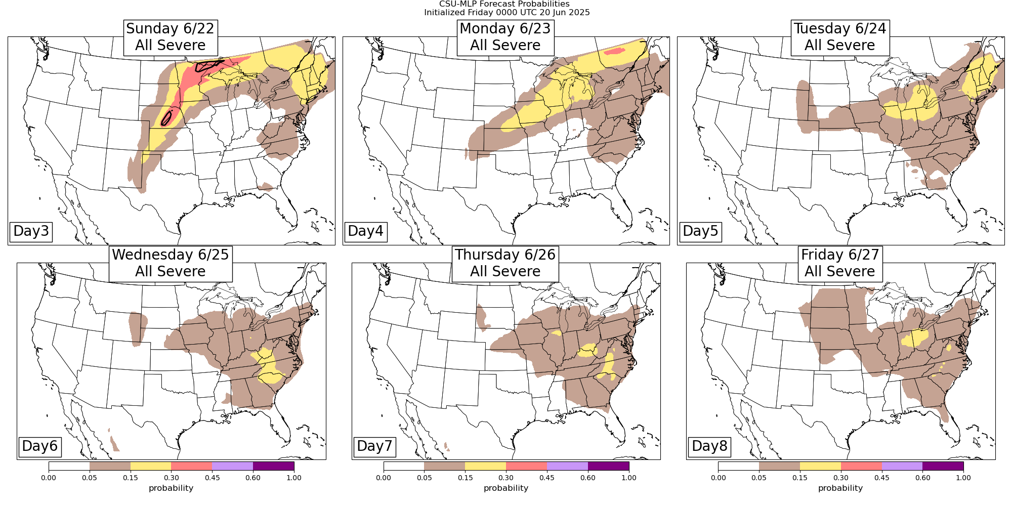
Severe thunderstorm activity will also remain heightened early next week. As disturbances rotate around the northwest and north side of the heat dome, severe thunderstorms will feed off the extreme instability produced by the heat and humidity. While the exact areas of greatest risk will likely evolve a bit, the Colorado State University Machine Learning probabilities show the general areas of greatest risk. By the middle to latter part of the week, the weakening upper level high pressure center will result in the severe weather risk becoming more uncertain.

Leave a comment