Severe weather and flash flood concerns as well this week
The heat wave we have been talking about for several days has now fully arrived. While Saturday saw a handful of record high temperatures across the Midwest, the heat was especially prevalent in record warm minimum temperatures, as dozens of records were set, and in some cases by several degrees. This included Omaha (82F, previous record was 79F in 2013), Chicago (78F, previous record 74F in 1923), Des Moines (80F, previous record 77F in 2013), and Minneapolis/St. Paul, which with an overnight low of 80F not only broke the daily record by 6 degrees, it was also the earliest 80F minimum on record.
We have discussed this in previous posts, but I think it is important to reemphasize that while record high temperatures get a lot of the media coverage, the record warm minimums have a particular fingerprint of climate change because the increased capacity for the atmosphere to hold moisture is likely contributing to increasingly warm overnight low temperatures. Additionally, warm overnight lows are a significant contributor to health impacts of heat waves as the lack of morning cooling precludes relief and contributes to the cumulative effect of prolonged heat waves.

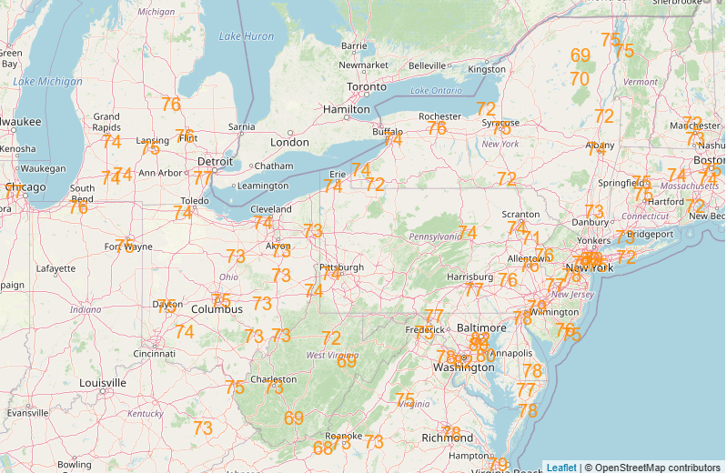
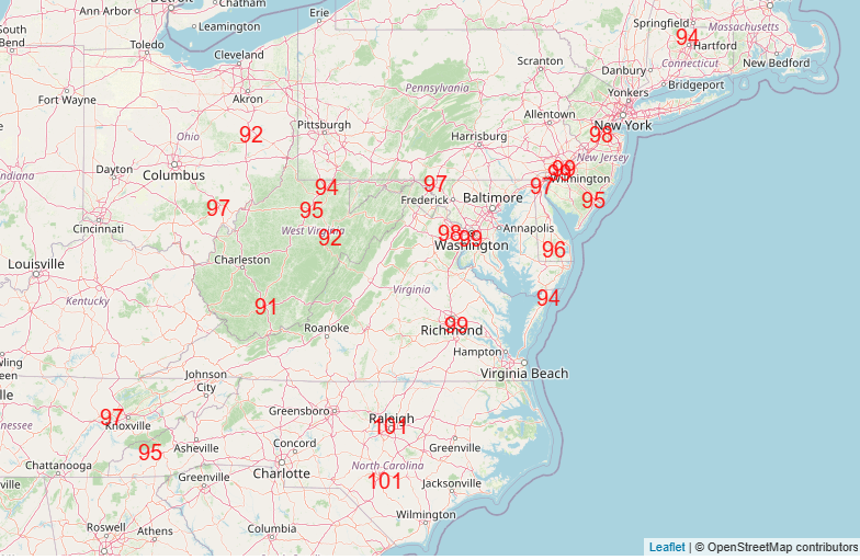
Unfortunately, the next couple of days will see the complete gamut of a heat wave, with increasingly widespread record high maximum and record warm minimum temperatures (Monday forecast record highs and Tuesday forecast record warm minimums shown above), combined with oppressive humidity.

Widespread major to extreme heat risk today will expand and intensify over the Ohio Valley, Mid-Atlantic and Northeast regions Monday and Tuesday, while a cold front will move into the upper Midwest region bringing some relief there.
It still looks like Tuesday will be the peak day for the heat wave, as the upper level area of high pressure will begin to weaken a bit starting Wednesday. However, Wednesday will still see a number of record high temperatures across the Mid-Atlantic region.

The upper level high pressure area is expected to remain in place through the end of the week across the Mid-Atlantic, Southeast and upper Ohio Valley regions, leading to continued major to extreme heat risk. Such a prolonged period of excessive heat is unusual, particularly for areas farther north from the Ohio Valley into the DC region. People should take the heat risk seriously – heat is the number one weather related cause of fatalities in the US.

In the West, a large upper level trough will be in place the next couple of days upstream of the heat dome in the East. The much cooler air here will result in a handful of record cool maximums today and record low temperatures on Monday morning – but as I talked about in my climate post Friday, as is now common the record cool temperatures in this weather pattern will be dwarfed by the record warm temperatures. The strong winds and dry conditions associated with this cooler weather pattern in the West have led to a significant increase in wildfire activity, The Hotshot Wake Up Substack has a good overview of the latest developments.

As far as thunderstorm activity, overnight a complex of severe thunderstorms came south out of Canada and produced quite a bit of wind damage in central New York where over 50,000 customers are without power this morning. This complex of thunderstorms weakened this morning but is still festering around the central New York/Pennsylvania border region at midday.

With daytime heating, there will likely be some increase in the intensity of this activity again this afternoon, and SPC has a slight (level 2 of 5) risk of severe weather in the region with damaging downburst winds the primary risk. How this complex will evolve and move is a challenge as it will primarily be driven by individual thunderstorm development, and while it’s a lower probability, it’s possible this complex could build southwest down toward the DC metro area or into southwest Pennsylvania and West Virginia by this evening.
In the middle part of the country, scattered severe thunderstorms are anticipated along a slow moving cold front. The atmosphere will likely become very unstable in this region and some significant severe storms with very large hail, 75+ mph straight line winds and tornadoes are possible. While we continue to watch for the potential for a damaging bow echo complex of severe storms similar to what occurred in North Dakota Friday night, morning high resolution models suggest that the greatest risk for this later today and tonight should be just across the border in Canada.
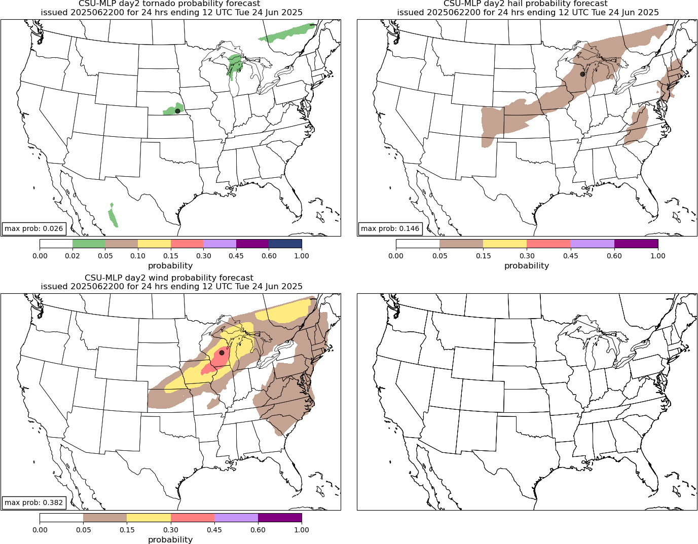
Heading into Monday, the risk of severe storms will extend along the cold front from the Great Lakes into the mid-Missouri valley. Damaging winds look again to be the biggest risk with the severe storms. Beyond Monday, a risk of severe storms will likely continue around the periphery of the eastern US upper level high, but will be driven primarily by lower predictability daily development of thunderstorm complexes.
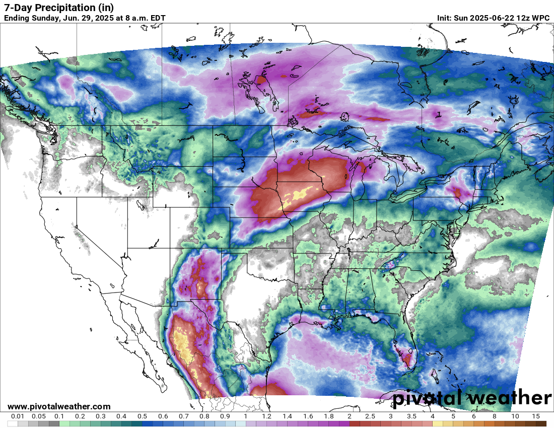
Another concern around the periphery of the upper level high will be the potential for heavy rainfall and flash flooding. The rather stagnant weather pattern for several days will lead to a persistent plume of moisture from New Mexico into the upper Midwest where numerous thunderstorm complexes will move across the same region. Flash flooding will likely become an increasing concern across this general area.
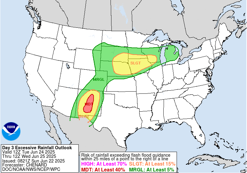
In fact, the Weather Prediction Center has placed a moderate (level 3 of 4) risk of flash flooding across central New Mexico for Tuesday as the flash flood risk should maximize during the early part of the week there. Flash flood risks will continue for parts of the upper Midwest and into the Great Lakes for much of the week.

Leave a comment