Major heat wave in Europe sets all-time June record maxes in Spain and Portugal
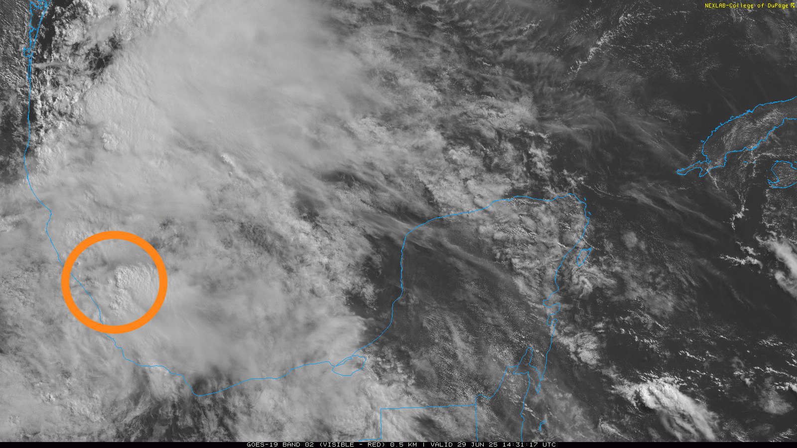
We have our second named tropical storm of the season. Barry (shout out to my long time great friend Barry who was one of the first founding subscribers to this Substack, thanks) was designated in the southwest Bay of Campeche on the most recent advisory from the National Hurricane Center (NHC). If you are familiar with looking at satellite loops of tropical cyclones you might think that Barry doesn’t look like much – and you would be right. It is a rather disheveled looking system, with some upper level shear from a low to its north, and increasing upper level shear to its south from upper level outflow from recently designated Tropical Storm Flossie in the eastern Pacific (more on that later).

However, there looks to be a pretty well defined low level circulation in the area I circled in the satellite loop, and luckily we have a reconnaissance aircraft in the system and it confirms that we do have a well defined low level circulation. In fact, dropsonde (an instrument like a weather balloon instrument only dropped out of the plane to splash in the water) data indicates that the circulation is becoming a bit better developed, with pressure down to 1006 millibars and surface winds in the 35 to 40 knot range. All of that pretty clearly supports a minimal tropical storm, and the hurricane center thus designated Tropical Storm Barry.
![[Image of rainfall potential]](https://balancedweather.com/wp-content/uploads/2025/07/cfc01-3bb8a3c5-e542-4b1e-9e5c-b536ecec68e6_3300x2550.gif)
While the storm may intensify just a bit more, Barry (luckily the storm, not my friend) is not long for this world, as it slowly tracking west-northwest toward the coast of Mexico and will be making landfall later today. Once that happens, it will rapidly dissipate in the mountainous terrain. However, heavy rainfall will continue for a few days, and amounts of up to 10” could cause life-threatening flash floods and mudslides.
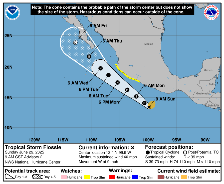
Meanwhile, we also have a new tropical storm in the eastern Pacific, as Flossie was also designated this morning. Flossie is in a more favorable environment and will be over water for several days, paralleling the southern coast of Mexico. Hence, it is expected to become a hurricane in the next day or two. It should stay far enough off the coast for the worst impacts to remain over water, but strong winds and heavy rains are possible along the Mexican coast and tropical storm watches are in effect. As we discussed yesterday, moisture from Flossie may eventually enhance monsoonal thunderstorm activity in the Southwest US later this week.

Before we leave the tropics, I want to mention that NHC has also highlighted an area off the Southeast US coast to monitor for possible development late this week. There have been some occasional signals in the long range models of the potential for a system to develop along an old stalled out frontal boundary in this region in several days. This is a pretty common mechanism for tropical development at this time of year, so it’s something we should keep an eye on. Right now, it does not look to be any more than a low probability setup, but we will continue to monitor.
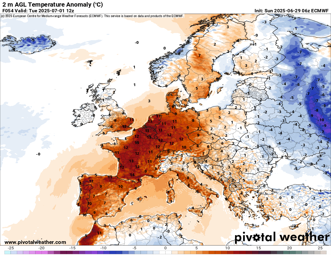
Turning our attention now to another summer hazardous weather threat, heat. A major heatwave has been evolving over southern Europe and northern Africa, and yesterday Spain and Portugal set all-time record maximum temperatures for June, with 45.8C (114F) at El Granado, Spain and 45.4C (114F) at Alvega, Portugal. Similar or even hotter temperatures are expected today, and the heat will intensify and expand through midweek to encompass much of northern and central Europe. Widespread anomalies of 10 to 15C above normal are anticipated, with 40C (104F) possible in Paris and maxes greater than 100F possible into Germany.
Japan also continues to see extraordinary record heat, and the prolonged heat here is causing concerns about energy demand as reported by Bloomberg.

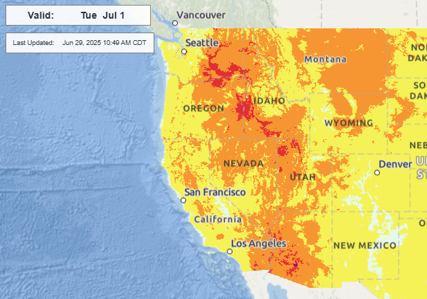
While the eastern US heat dome has weakened, hotter conditions have been redeveloping in the western United States, and heat advisories and extreme heat warnings are in effect for a number of inland areas. Phoenix is expected to approach or exceed 115F the next few days, with the western heat reaching a peak on Tuesday as shown above.
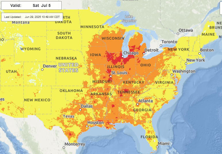
Heat is expected to build and shift east through the week, and by the holiday weekend widespread moderate to major heat risk is expected in the Midwest and South.
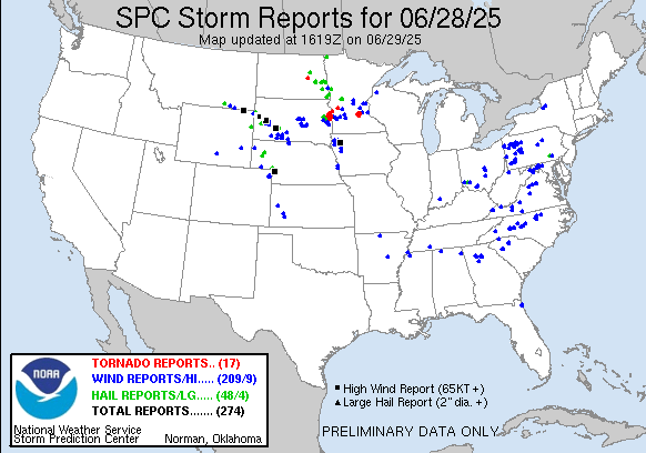
As far as severe thunderstorms are concerned, Saturday was a very active day as expected in the upper Midwest, with a number intense severe storms that produced tornadoes, very large hail and wind gusts greater than 75 mph. Scattered severe storms with damaging downburst winds affected parts of the east.
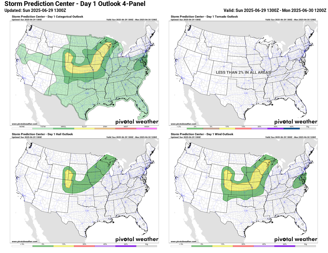
Today, the risk of severe weather should be a bit less than Saturday, with a slight (level 2 of 5) risk across parts of the Midwest and Plains, primarily for damaging winds and some risk of large hail. A marginal (level 1 of 5) risk is in place for the Mid-Atlantic region for the possibility of a few severe storms with damaging downburst winds.
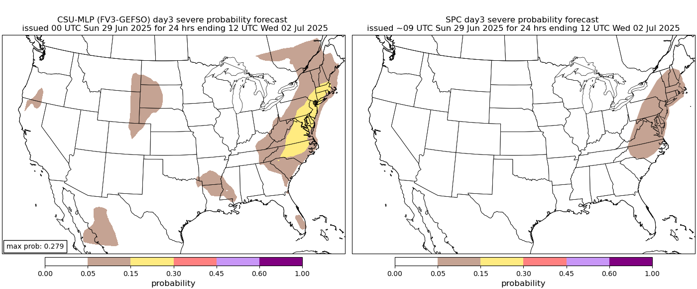
A more organized risk of severe weather is possible along the East Coast on Tuesday as the cold front over the Midwest today reaches the region. Beyond Tuesday, the risk of severe storms looks more nebulous as the weather pattern looks to become increasingly under the influence of building high pressure aloft across the South and Midwest.

Leave a comment