July 1 Tropical Newsletter
The last week surprised with two named systems in the Atlantic basin, Andrea and Barry. Both, however, were very short lived, weak systems. Forming east of Bermuda, Andrea literally didn’t survive 24 hours. Barry was a bit more persistent and impactful, forming in the Bay of Campeche over the weekend and making it to a 45 mph tropical storm before landfall along the east coast of Mexico Sunday evening. However, it was a very small storm that always looked “messy” in satellite data, and as pointed out in this BlueSky post by my meteorological colleague Jimmy Yunge, without aircraft reconnaissance it might not have even been designated a system.

For the upcoming week, we will be keeping an eye out for possible tropical cyclone formation from a process that is very typical for this time of year, namely a low pressure system forming along an old frontal boundary. A weak cold front is expected to stall out from the northeast Gulf into the southwest Atlantic in a couple of days. With a plume of deep tropical moisture in place, thunderstorms will form repeatedly along the front, and with time it is possible that storms could congeal and start to form a low pressure system.
The weather models have been suggesting for several days that development is at least possible in this setup, and over the last 24 hours or so seem to be focusing more on the area east of Florida for something to possible develop in about 6-7 days. Interestingly, the European ensemble models have been more bullish on possible development than the normally excitable US Global Ensemble Forecast System. Regardless, at this point NHC has a 30% probability of development over the next week, and for now it’s just something to be aware of. Right now, there do not seem to be any other areas to keep an eye on in the Atlantic.
![[Key Messages]](https://balancedweather.com/wp-content/uploads/2025/07/6c05e-272765fe-35ca-4862-bcdb-99bc91696f03_897x736.png)
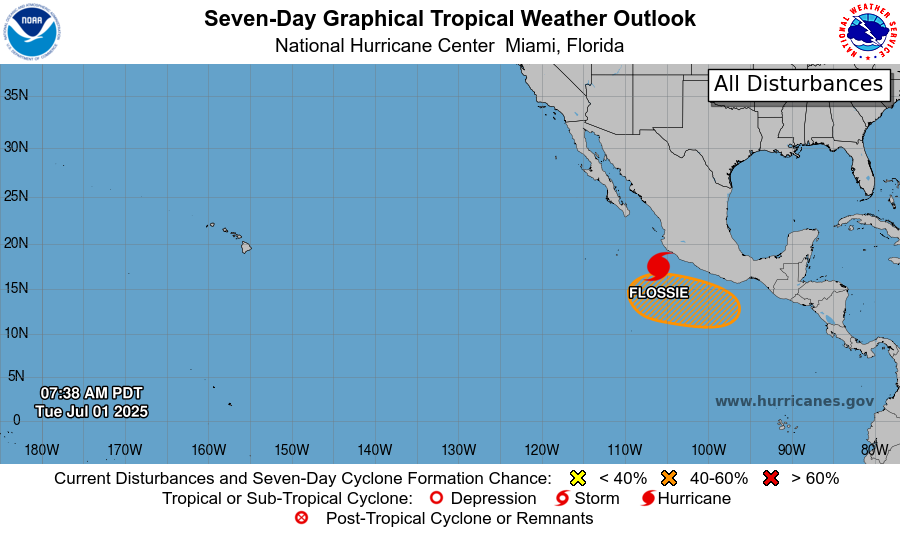
Meanwhile, in the eastern Pacific we have yet another hurricane, with Flossie now a category 2 hurricane with maximum sustained winds of 100 mph. Flossie has been strengthening steadily and still has about another 24 hours in favorable conditions; NHC now forecasts it to become a major hurricane before it starts to weaken over colder waters. It will turn west and dissipate in a few days. Flossie will remain offshore of coastal Mexico, but is currently close enough for the outer bands to impacting parts of the coast where tropical storm warnings are in place. Localized flash flooding is also possible.
Once Flossie moves out of the way, conditions look favorable for yet another tropical system to develop south of coastal Mexico, and NHC has a medium (40%) chance of development of a tropical cyclone this weekend.

As we start July, it’s a good time to take stock of where we are as far as tropical activity. The best way to track the overall activity level of a tropical season is using Accumulated Cyclone Energy (ACE), a parameter that essentially takes the size and strength of each ongoing tropical cyclone and adds it up over time, to give a quantitative estimate of how intense the season was. So far the Northern Hemisphere is well below normal as far as activity, with the usually most active west Pacific well below normal. While the eastern Pacific has seemed active, overall its activity is really only slightly above normal for the end of June. The Atlantic has been a bit below normal – but it is important to emphasize that the level of activity in June and July in the Atlantic does not have a significant correlation with how busy the peak of the season from August to October is.


Sea surface temperatures remain above normal over most of the Atlantic basin. Over the last month, conditions have warmed dramatically in the north Atlantic off the East Coast, with warmer anomalies also noted over the tropical Atlantic. Meanwhile, the Gulf and Caribbean, which were running at near record SSTs, have seen their anomalies decrease a bit. The Madden-Julian Oscillation (MJO) that can provide more favorable conditions for tropical development continues to be weak, and Climate Prediction Center scientists indicated in their MJO discussion this week that other tropical influences suggest that the eastern Pacific and Atlantic will see less favorable than normal conditions for tropical activity in July after the next 7-10 days.

Leave a comment