National wildfire level moves to 2nd highest possible
Starting off this morning with news regarding the NOAA budget. In what is the clearest statement I have seen so far with regard to Congressional pushback on the Trump Administration’s proposed cuts to NOAA, including the elimination of the Office of Oceanic and Atmospheric Research (OAR), House Appropriations Committee Chair Tom Cole, an Oklahoma Republican whose district includes NOAA’s National Severe Storms Laboratory (NSSL), told the Norman Transcript that NSSL would be fully funded. From the article:
He said the proposed NSSL closing is off the table. “You’re going to be fine in our bill. We’re going to protect it, and we’ll be coming out in the next few weeks,” Cole said. “The basic funding structure, the basic employment stuff, is going to be okay. The National Weather Center is in Norman. It’s not going anywhere, and it’s going to be fully staffed and maintained.”
The Congressman went on to say:
“The President proposes, but Congress decides,” Cole said. “The President’s budget is designed by the Office of Management and Budget, and they’re proposing a lot of stuff that they know is not going to happen, and that’s one of them…I’ve never seen a presidential budget that survived contact with reality, it doesn’t matter whose it is. Kind of a standing joke.” Cole said, however, that Trump does control grants, and many of those grants work in other parts of the National Weather Center, such as The Cooperative Institute for Severe and High-Impact Weather Research and Operations, which remain in some jeopardy. CIWRO is a mechanism that links the scientific and technical resources of OU and NOAA and researches weather radar improvements, storm system modeling, forecasting improvements, and seasonal predictions for extreme weather.
At a high level, this is clearly positive from the standpoint that it shows the intent of the House Appropriations Committee to not blindly accept the President’s budget of massive cuts to NOAA including the elimination of OAR, and comes in the wake of the Senate Appropriations Committee debate on the Commerce, Justice and Science bill which seemed to also indicate bipartisan rejection of the proposed cuts to NOAA, NASA and NSF. However, the federal government is a complex machine, and Rep. Cole’s comments about the administration controlling grants is acknowledgment of the power that the president does have to control research work through blocking the release of grant money.
The reality is that at a NOAA federal lab like the National Severe Storms Lab (NSSL), most of the actual day-to-day scientific research work is done by university cooperative institute employees, in this case the University of Oklahoma Cooperative Institute of Severe and High-Impact Weather Research and Operations (CIWRO). To provide some perspective, while I do not have exact figures given recent job losses, NSSL has in the neighborhood of 60 federal employees, and at least 15 of those are administrative and management positions that do not do scientific research work. Much of the scientific effort of the lab is invested in more than 150 CIWRO research scientists and associates who are funded through NOAA grants to the cooperative institute. While obviously maintaining NSSL (and the other federal NOAA labs) in some form would be preferable to complete elimination, NOAA labs without the university cooperative institutes would be a radically different structure that would likely have much less research capacity than they currently do.
Furthermore, as I discussed just yesterday, this administration has exerted its power even more than through the control of grants as Rep. Cole talked about, and has been aggressively pursuing agency reorganizations and reductions unilaterally as with layoffs at the State Department in the last couple of days. So while Cole’s comments are definitely positive, until there is actually an FY26 budget passed by Congress and signed by the President, the administration has most of the control, and we will see what actions they take in the coming weeks. The next step in the FY26 budget process will come on Tuesday when the House Appropriations Commerce, Justice and Science (CJS) subcommittee will hold the markup hearing on its budget bill, which includes the appropriations for NOAA.
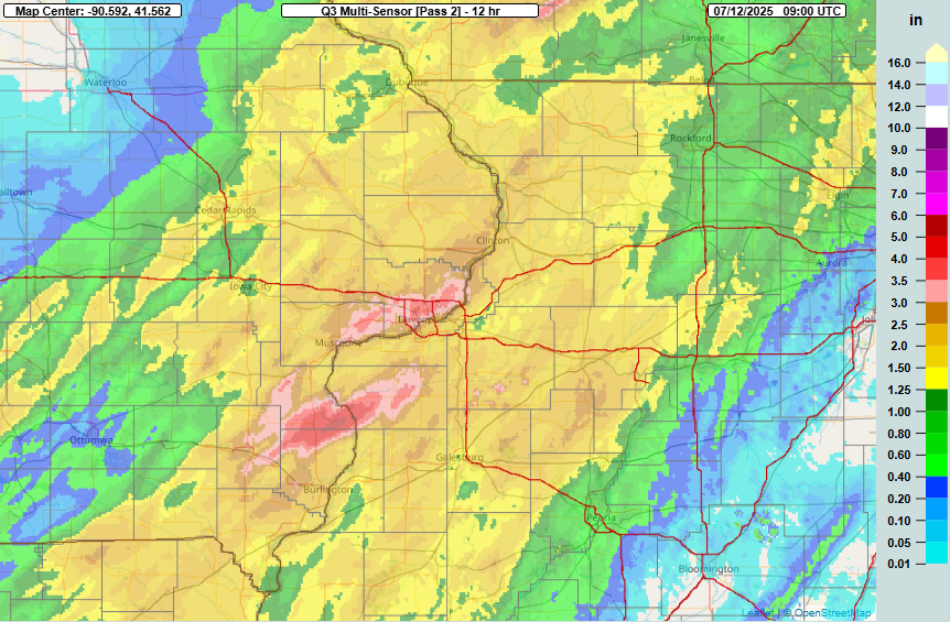
Turning now to the weather, yesterday saw another significant heavy rainfall and flash flooding event, this time across eastern Iowa and northwestern Illinois.

The most impacted area was the Davenport, IA area, and once again intense rainfall rates driven by abnormally high levels of moisture drove the impacts. Much of the Davenport area received 2-3” of rain in just an hour between about 5 and 6 pm.
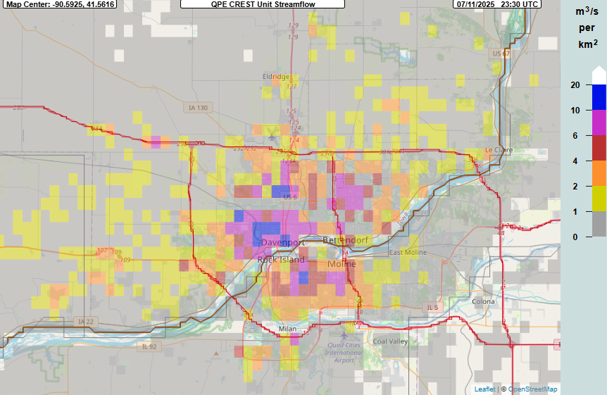
The MRMS FLASH hydrologic product that we have been using so much in recent days once again shows how these intense rainfall rates overwhelmed the more urbanized landscape in the area, with areas of unit streamflow exceeding 10 units, indicative of significant flash flooding. The local NWS office issued a flash flood emergency, and flash flood impacts were major and widespread, with numerous vehicles and buildings flooded and many water rescues taking place.
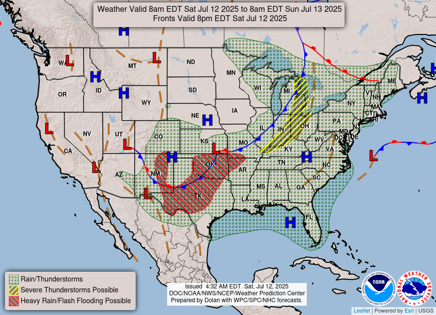
Today the primary flash flood risk will shift to the Southern Plains and parts of New Mexico, where a slow moving front will focus thunderstorm activity in an area again characterized by unusually high levels of atmospheric moisture.
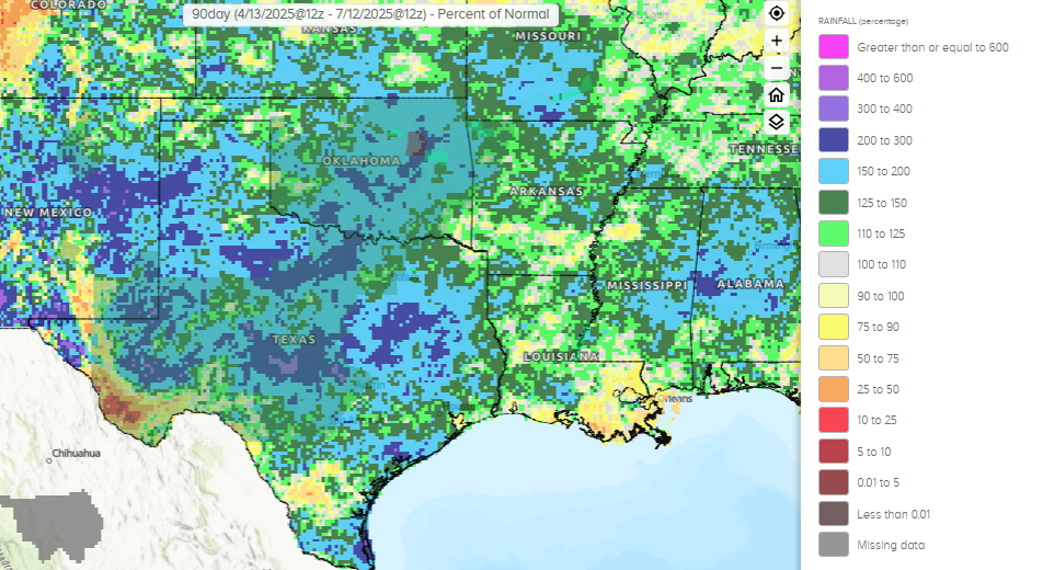
Much of this region has seen unusually large levels of rainfall in the last 3 months, with some spots having seen more than twice their usual levels of rainfall. This has left much of the area vulnerable to flash flooding with heavy rainfall, and the Weather Prediction Center has a large slight (level 2 of 4) risk in place. The risk area does include much of the Texas Hill Country and the Ruidoso, NM area which were all hit by major flash flooding in the last 10 days.

Yesterday was also an active severe weather day, particularly in that eastern Iowa, northwest Illinois and southern Wisconsin area where numerous significant damaging wind gusts and at least a few tornadoes occurred. Some strong to severe thunderstorm activity will be possible again today along the front, with the greatest severe weather risk in the Great Lakes region where a slight (level 2 of 5) risk is in place, with damaging wind gusts the primary severe weather risk.
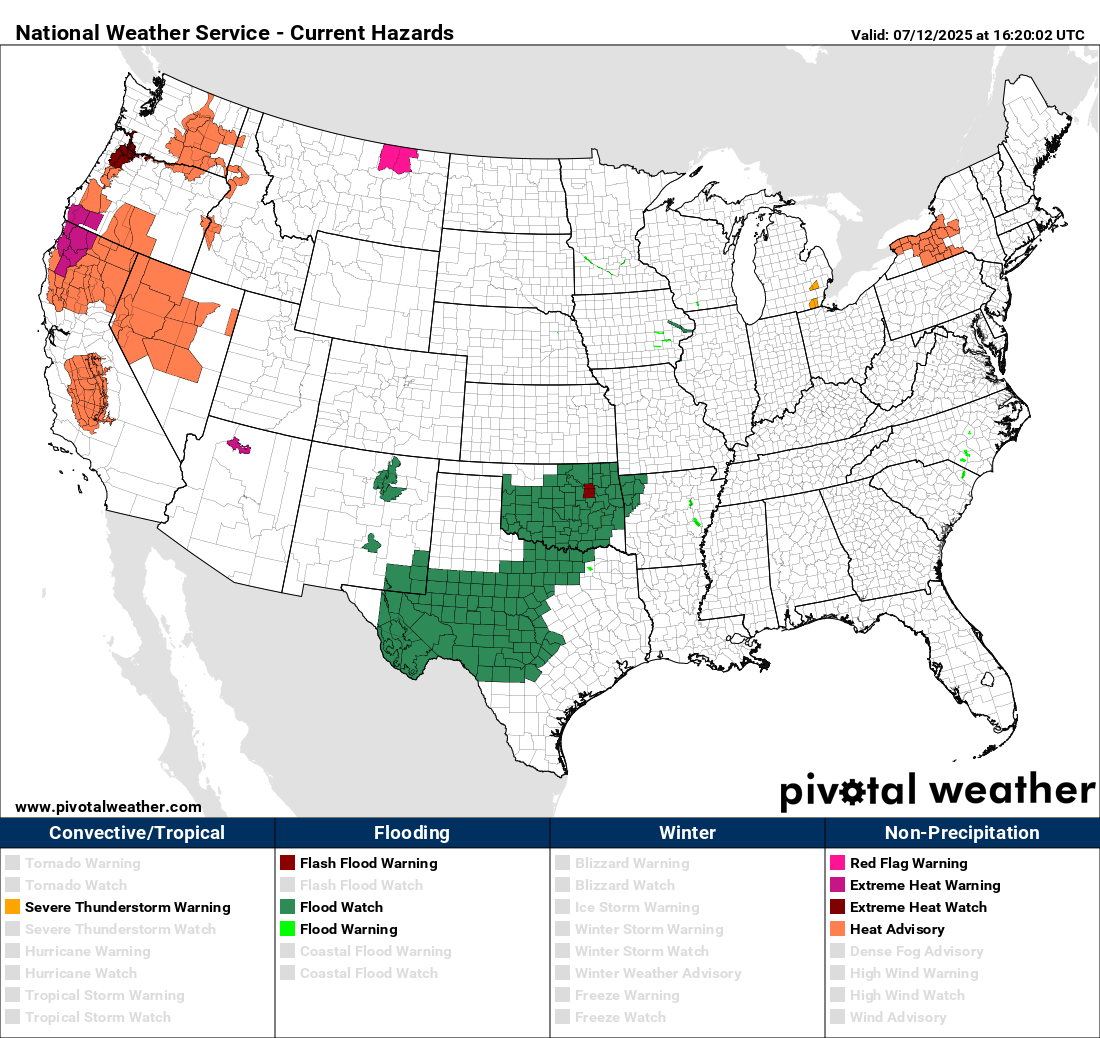
In the West, heat and fire danger continue to be the primary weather hazards, with red flag warnings and heat advisories in effect for a number of areas. Wildfires have been increasing in number and severity in several western states this week. This morning, the National Interagency Fire Center (NIFC) raised the national preparedness level (PL) to 4, which is the second highest level. NIFC reported on their morning report that 7 new large fires were reported on Friday, bringing the total number of uncontained incidents nationally to 34. Alaska has been having a particularly active summer with 60 large fires and a state PL of 5.

We haven’t had to talk about it much in a while, but with northwest atmospheric flow behind the cold front in the middle part of the country, Canadian wildfire smoke has once again become a significant issue in the upper Midwest. The forecast from this morning’s High Resolution Rapid Refresh smoke (HRRR-Smoke) model shows several waves of thicker near surface smoke moving through the upper Midwest and Great Lakes region the next 48 hours. Air quality alerts are in effect this weekend for all of Minnesota, Wisconsin and Michigan. As you can see in the forecast animation above, areas of wildfire smoke are also becoming an increasing issue due to fires in the western United States, and air quality alerts are also in effect for parts of southwest Colorado due to wildfire smoke concerns.

Leave a comment