Moderate risk of flash flooding for the Mid-Atlantic on Thursday
Jul 30, 2025
My rhythm of posts has been off the last few days as I have been traveling. Home now and doing an afternoon post, and starting off for a change with good news from the government weather apparatus. As my colleague Michael Lowry reported yesterday, the Department of Defense made a last minute decision not to terminate access to the SSMIS polar orbiting satellite data that is particularly critical for tropical cyclone forecasting. Michael quotes a Navy spokesperson as stating that feedback received about the DoD’s move to discontinue the data led “officials to (find) a way to meet modernization goals while keeping the data flowing until the sensor fails or the program formally ends in September 2026.”
While this will still leave us in the lurch without SSMIS data late next year as I talked about here, it at least will keep this important data flowing as long as possible. Just this week, Central Pacific Hurricane Center forecasters used SSMIS microwave data to recognize unanticipated rapid intensification of Hurricane Iona and adjust their forecast accordingly. The fact that the Navy acknowledges that feedback is what led them to reevaluate this data termination shows that there is still room for advocacy about these sorts of situations to make a difference.
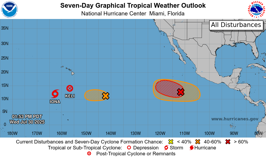
After peaking as a major hurricane yesterday, Iona has weakened rapidly and is now a tropical storm as it moves well southwest of Hawaii. The short-lived tropical storm Keli has degenerated to its east. Another system east of the remnants of Keli could develop into another short-lived system but is not expected to do much. Farther east, the next more significant system to watch is Invest 99P in the eastern Pacific several hundred miles southwest of the southwestern coast of Mexico. 99P is expected to develop into a tropical cyclone in the next couple of days and likely become a hurricane as it moves west northwest. As of now, it appears as though it will not impact any land areas, staying well offshore of Mexico and likely to remain east of Hawaii. The Atlantic remains quiet for now, but signs still indicate a more favorable atmospheric setup for development across the basin starting next week.
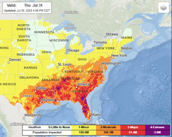
As expected, heat has been the dominant weather story over much of the country the last couple of days, with numerous record warm temperatures – both maxes and mins – set in the eastern United States. A slow moving cold front is slowly bringing relief from the north, but Thursday will be another day with widespread major to extreme heat risk across a broad region from Texas to Virginia and south across Florida.

A weak area of low pressure developing along the front on Thursday is expected to focus thunderstorm activity with very heavy rainfall rates across the Mid-Atlantic region. The Weather Prediction Center recently upgraded the area from the DC metro northeast to the New Jersey suburbs of the NYC metro area to a moderate (level 3 of 4) risk of flash flooding for Thursday.
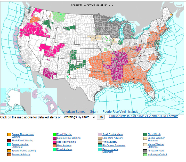
Finally, I want to mention that fire danger concerns persist across parts of the West, with red flag warnings in effect in a number of areas. Canadian wildfire smoke is moving southeast behind the cold front dropping into the eastern US, and air quality alerts are in effect for all of Minnesota, Wisconsin and Michigan. While cooler conditions are infiltrating parts of the eastern United States, heat is building in the Southwest, and extreme heat warnings are in effect starting Friday in southern Arizona where high temperatures of 110F or greater will be possible.
Thanks for your patience with my irregular schedule the last few days – back to normal starting Thursday morning.

Leave a comment