Will bring increasing fire danger as well
Aug 03, 2025

I want to spend much of today’s newsletter doing a bit of a deep dive into the major heatwave expected this week in the Southwest, and the increasingly concerning fire situation for much of the western US.
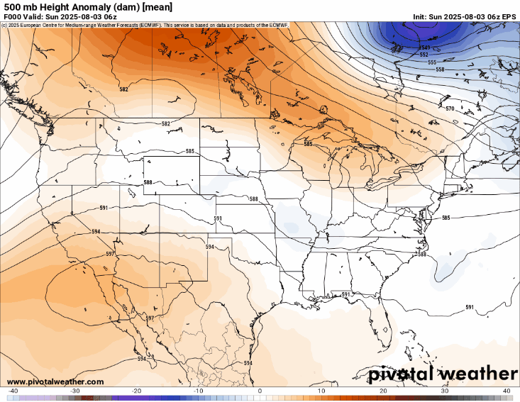
This loop shows contours of geopotential height – similar to pressure lines on a surface weather map – for this week’s forecast from the European Centre (ECMWF) ensemble model at 500 millibars (mb), about 18,000 ft up in the atmosphere. This is the level that meteorologists primarily focus on to look at the weather pattern in the middle and upper levels of the atmosphere. The background image on the loop is the anomaly – the difference in the geopotential height from normal.
You can see an unusually strong area of high pressure develops over the next few days across the Southwest, peaking on Thursday. A strong area of high pressure aloft like this generally produces sinking motion in the atmosphere, which suppresses any clouds/rain and results in warming throughout the atmosphere, including at the surface. This is the “heat dome” feature that you will see meteorologists and the media talking about during heat waves.
My meteorological colleague Eric Webb pointed out on Bluesky that this heat dome is likely being driven by the Madden-Julian Oscillation (MJO) feature that I have been talking about in our tropical updates. Thunderstorm formation associated with the multiple tropical cyclones developing in the Pacific due to the MJO passage releases heat into the atmosphere, which has likely been transported into the Southwest US and is helping to develop this intense area of high pressure.
This heat dome will result in a number of days of record heat across the region, peaking on Thursday with numerous record highs from the the deserts of the Southwest into the central Rockies region. Obviously, with ambient temperatures above 100F, and in many desert locations above 110F, heat stress will be major to extreme as shown on the NWS HeatRisk graphic at the top.
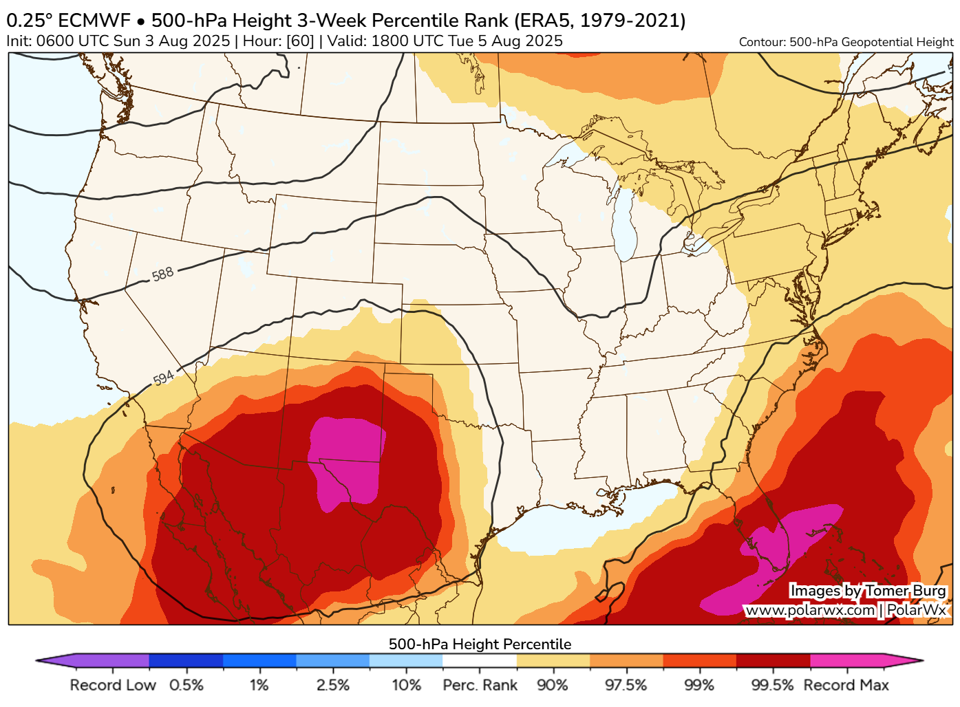
As seems to always be the case now when we have summer heat waves, I am seeing people on social media saying things like “Welcome to August,” implying that this is just typical summer heat. The reality is that this is just not true. This graphic from the incredibly talented meteorologist Tomer Burg’s website shows the 500 millibar geopotential height forecast from the ECMWF model for midday Thursday, and the image is showing the percentile of the height value, i.e. a 99% percentile means that only 1% of the values in the historical database are higher than what is being forecast for Thursday. In this case, you can see that the forecast geopotential height over southern New Mexico would be an all-time record for this time of year.
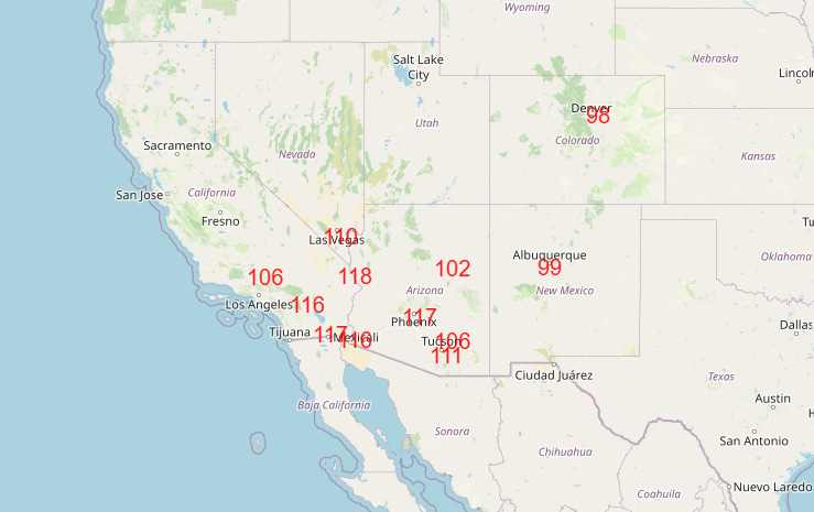
Correspondingly, the forecast maximum surface temperatures on Thursday are not only expected to be daily records, but in some cases will be near all-time monthly records. 117F at Phoenix would break the daily record by 5 degrees and tie an all-time record for the month; 111F at Tucson would be within a degree of their all-time August record, and 102F at Winslow would be within 2 degrees.
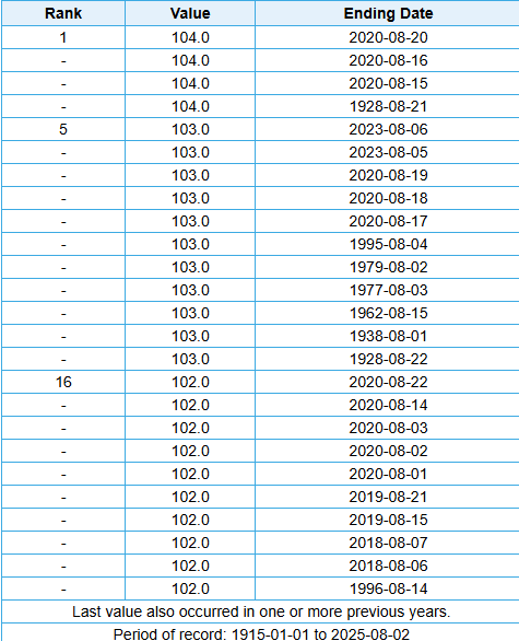
It is also important to recognize that this late summer heatwave typifies a trend toward hotter conditions later into the summer in this region. Just picking Winslow as an example, of their 25 hottest August afternoons in history, 17 of them have occurred since 2018 (Winslow has 110 years of data). A similar sort of trend can be seen at most long term climate sites in the Southwest; of the top 25 hottest August afternoons in Phoenix, only 2 occurred prior to 2000, and the latest was in 1972.
Phoenix has also now had 6 consecutive years with a week stretch of high temperatures 110F or higher, after having never had more than 2 consecutive years of such a weekly stretch.
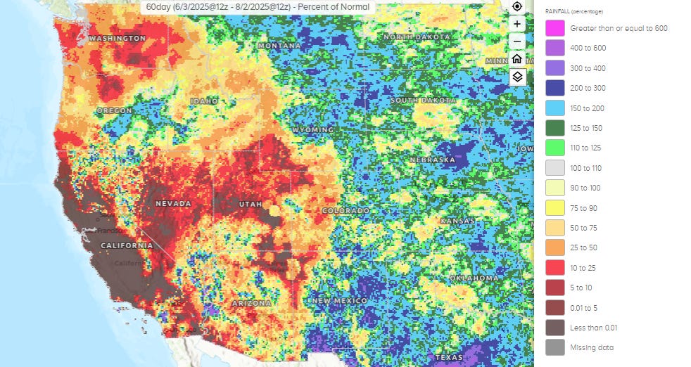
Heat is not the only concern in the West this week. Much of the West has had an unusually dry summer. While most of California normally sees little if any rain this time of year, other parts of the West do typically see wetting rainfall, and as you can see, for much of the region it has been pretty sparse.
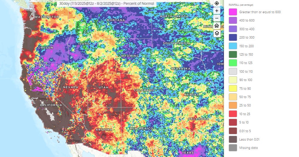
The last month has been particularly dry for the Southwest and Intermountain West, as the Southwest monsoon has been very unproductive west of the Continental Divide. It has also been unusually dry for coastal Washington and Oregon.
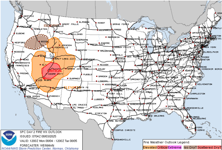
Multiple large wildfires are already burning across the West, especially in Utah where as I mentioned yesterday the Governor has declared a 30-day state of emergency due to the wildfires and drought. Unfortunately, the hot, dry and at times breezy conditions will only result in a worsening fire weather situation this week, with critical fire conditions outlooked for much of Utah Monday and Tuesday. High based thunderstorms could lead to new fire starts the next couple of days, especially across parts of Oregon and Idaho.
If you go back up to the 500 mb loop, you will see a rather strong upper level trough of low pressure moving into the northern Rockies late this week. That will push a cold front into the Intermountain West which seems likely to bring stronger winds, and with dry conditions continuing could further increase wildfire spread. This front will bring a few days of relief from the worst of the heat this weekend, but hot and dry conditions are expected again much of the following week.

I will finish off today with a quick look at the weather for the rest of the country. The wavy stationary front that has become established from the Gulf Coast to the Rockies will continue to be the main focus for thunderstorm activity today. A slight (level 2 of 4) risk of flash flooding exists across parts of the Southeast and the Southern Plains. Severe thunderstorms (level 2 of 5 risk) are also possible in the Southern High Plains; scattered supercell storms could produce some very large hail, along with some incidences of damaging winds and a tornado or two
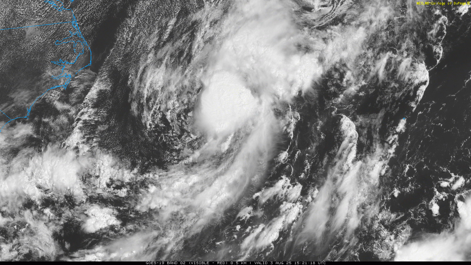
.The tropics continue to be active, but now the Atlantic basin is starting to get involved. This area of low pressure – designated Invest 95L – looks to be getting better organized over the last several hours. The National Hurricane Center has increased the probability of development to 50%, and it seems increasingly probable that we will see another short-lived tropical cyclone east of the Carolinas. There is already some wind shear affecting the system, and that will only increase over the next few days, so this system is unlikely to be anything more than a tropical storm. It should also move very quickly northeast away from land.
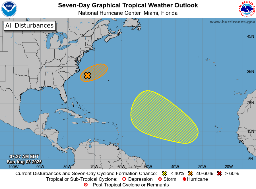
NHC has also outlooked a broad area of concern across the central Atlantic for late this week as the models indicate some potential for development here. Any system would likely be slow to develop and obviously we would have many days to monitor it for any sort of threat, although right now the weather pattern would generally favor any system remaining out over the Atlantic.

Leave a comment