Japan sets new record high temperatures; July 3rd warmest on record globally
Aug 06, 2025
As we approach the peak of another US heatwave over the next couple of days, it is worth taking a step back and looking at the bigger global picture. While we do not yet have the “official” data from groups such as NOAA and EUMETSAT Copernicus, climatologist Brian Brettschneider (link above, Brian is an incredible follow for awesome visualization of climate data) has posted his analysis which shows that July 2025 was the third warmest July on record, behind only 2023 and 2024. This continues a (to me) somewhat alarming and persistent trend of 2025 lagging just behind those two hottest years on record, despite the fact that 2025 is coming out of a La Nina year while 2023 and 2024 had strong El Nino conditions for much of the time. Typically, global temperatures set records during El Nino when the overall global warmth is higher; staying near the 2023 and 2024 levels of global temperature in neutral to weak La Nina conditions is rather remarkable.
Within this global warmth, eastern Asia has been dealing with an intense and prolonged heat wave. Japan has set a new national high temperature record twice in the last week, and has been dealing with serious heat impacts including tens of thousands of people having to be treated in hospitals for heatstroke, with dozens of reported fatalities.
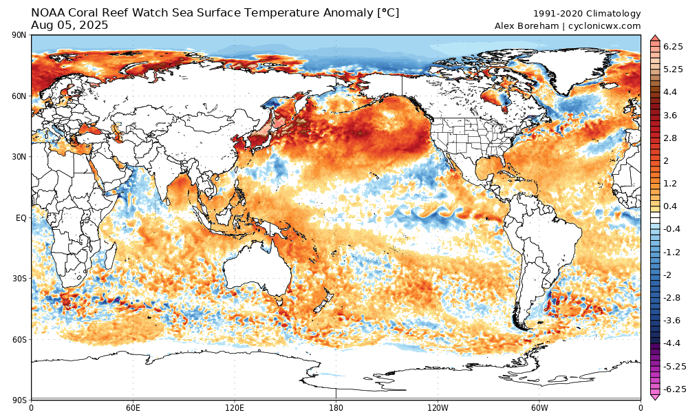
As Jeff Berardelli noted in this BlueSky post about the Japan national temperature record, the ocean waters around Japan are the most anomalously warm on the planet right now with sea surface temperature (SST) anomalies as much as +5C. This is part of an expansive area of anomalously warm SSTs that extends across much of the north Pacific. Obviously, there is a strong relationship and feedback between sea surface temperatures and air temperatures; you can also see anomalously warm water temperatures in the Black Sea, around Scandinavia, and in Indonesia, all areas that have also been experiencing record heat in recent weeks.
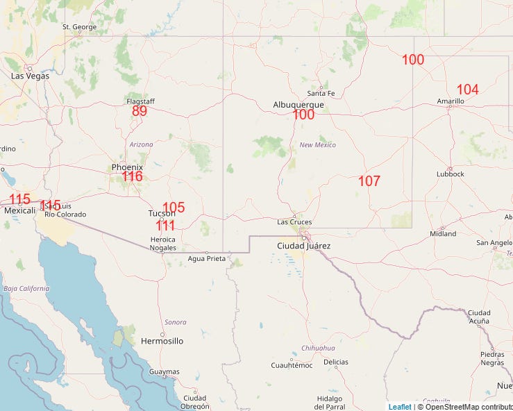
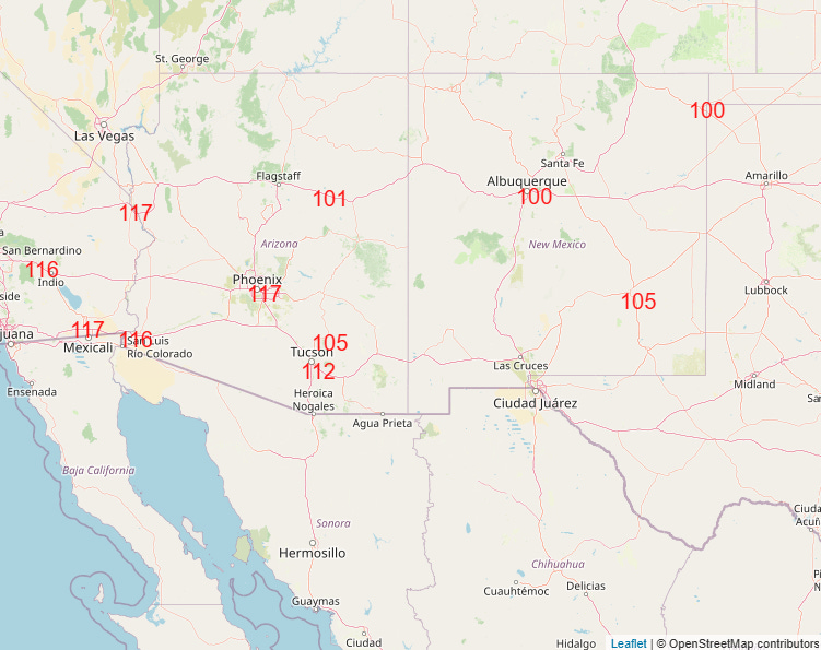
Coming back to the US, the record strong upper level area of high pressure is expected to peak in strength over the next 24-48 hours, with the heat at the surface peaking accordingly. A number of record high temperatures are anticipated today and Thursday (both shown above), with a few monthly record highs possible. The 117F forecast for Phoenix and 112F forecast for Tucson tomorrow would tie their all-time record highs for August.
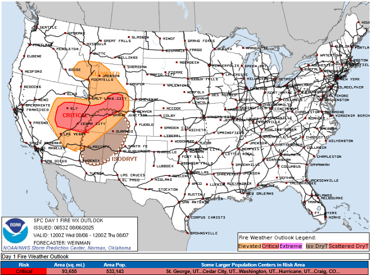
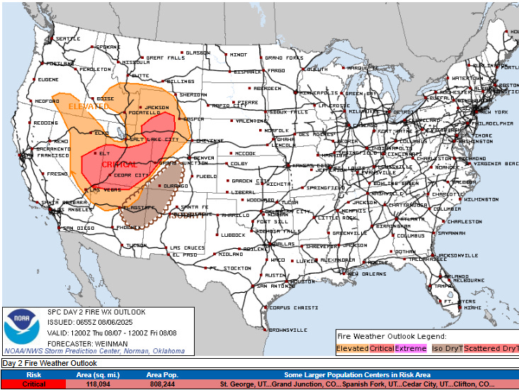
Fire danger will continue to be major concern in the west the next several days. The National Interagency Fire Center reported 8 new large wildfires in the last 24 hours, and as we have been discussing, fire weather conditions are expected to worsen for much of the Intermountain West over the next few days as an upper level trough and associated cold front will result in increasing winds.

Meanwhile, the East will continue to be generally cool and wet north of a stationary front along the Gulf Coast. A few record low maximum temperatures have been set in the Southeast due to the cooler weather and particularly widespread clouds and rainfall, a big change after last week’s intense heat. Persistent showers and storms with heavy rainfall in the Southeast may result in some flash flooding as well. South of the front, heat and humidity continue across Florida, and heat advisories are in effect for southern Florida as heat index values will max out near 110F.
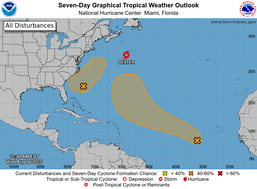
Turning to the tropics, not much has changed as far as expectations for the next several days in the Atlantic. Dexter is a tropical storm with maximum sustained winds of 50 mph and continues to move east into the open north Atlantic. The tropical wave in the eastern Atlantic is now producing some disorganized shower and thunderstorm activity, and overall conditions and model forecasts suggest the potential for development over the next several days. NHC has increased the probability of development to 60%, but the models have now come into pretty strong agreement that whatever develops from this system should remain east of any land except possibly Bermuda.
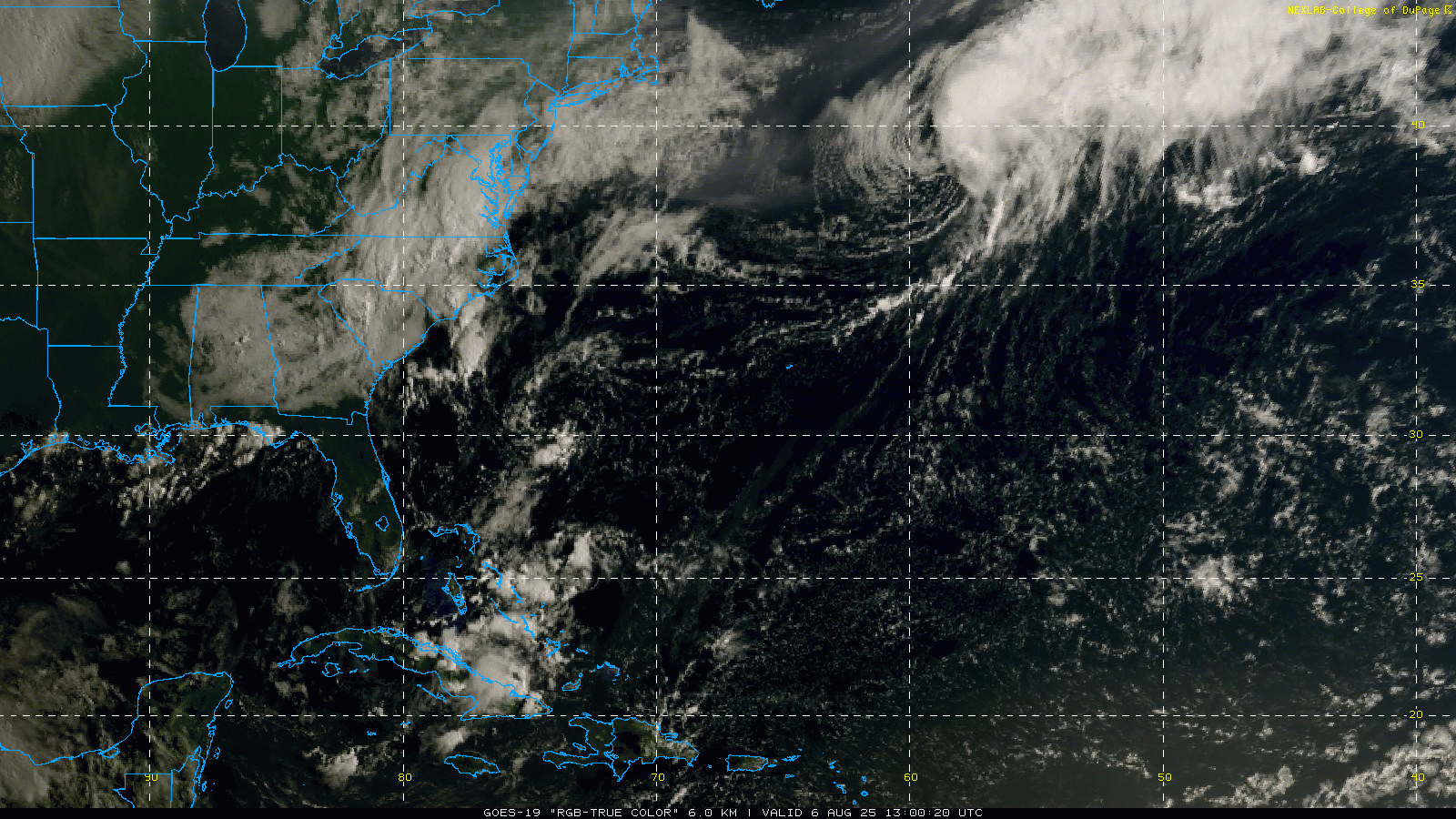
Of most interest to the US continues to be the broad area of disturbed weather of the Southeast coast. The visible satellite loop now shows two weak but discernible areas of sprin, one east of Savannah and the other approaching the eastern Bahamas from the east.
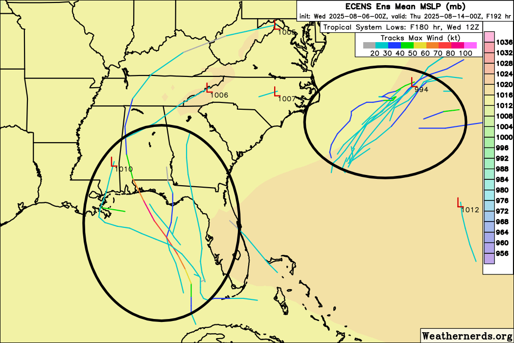
The area that NHC has highlighted off the East Coast is for the northern area of rotation, which the models generally show some weak development of. About a dozen (out of 50) of the European ensemble model members as shown here develop a tropical depression or storm out of that system over the next several days. However, the models have come into better agreement that anything that develops out of this should move northeast away from the coast.
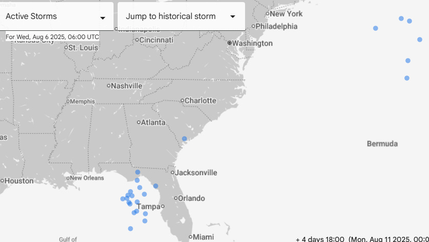
While not highlighted by NHC as of now, the more southern system continues to have a handful of European ensemble members showing development of it once it reaches the southeastern Gulf of Mexico region. This is still the system that the Google DeepMind AI system is more bullish on, with a number of its ensemble members showing a system in the eastern Gulf by early next week, along with a handful of members having a weak system north of Bermuda from the area NHC is currently monitoring east of Savannah. Right now we are in a monitoring stage, which we will continue to do and update accordingly.

Finally, I want to mention Tropical Storm Henriette in the eastern Pacific. It is currently a 50 mph tropical storm moving west-northwest over the east-central Pacific. If you scroll back up to the global SST anomaly map, you can see that water temperatures around and especially north of Hawaii are unusually warm. Given that, the current NHC forecast (and forecast models) actually show Henriette strengthening as it encounters that warmer water and somewhat favorable atmospheric conditions north of Hawaii in several days. Luckily, the system should remain far enough north of Hawaii to limit any direct impacts to the state.

Leave a comment