Heat and some significant severe weather threats dominate today’s weather
Aug 07, 2025
Starting off this morning sharing some perspective on comments by Department of Energy (DOE) Secretary Chris Wright Tuesday night during an interview with CNN’s Kaitlan Collins. As outlined in this CNN article, Wright said that the widely reported removal from federal websites of past National Climate Assessments was done so that the administration can “update” them.
“We’re reviewing them, and we will come out with updated reports on those and with comments on those reports,” Wright told CNN’s Kaitlan Collins in an interview on “The Source.” Wright dismissed the past reports, saying “they weren’t fair in broad-based assessments of climate change.”
To be clear, National Climate Assessments are not led by DOE, they are led by NOAA and the US Global Change Research Program, an entity which was established by Congress and whose website has been taken offline by the current administration. DOE and Sec. Wright did, however, play a key role in the development of a recent new federal report that downplayed the severity of climate change, and was used by the Environmental Protection Agency (EPA) to propose repealing their “endangerment finding” that anthropogenic climate change is a danger to human health and safety.
Wright told CNN that he hand-picked the four researchers and one economist who authored the Trump administration report: John Christy and Roy Spencer, both research scientists at the University of Alabama at Huntsville, Steven E. Koonin of Stanford University’s Hoover Institution, Georgia Tech professor emeritus Judith Curry and Canadian economist Ross McKitrick. “I just made a list of who do I think are the true, honest scientists,” Wright said. “I made a list of about a dozen of them that I thought were very senior and very well respected. I called the top five, and everyone said yes.”
Compared to the National Climate Assessments and international climate science reports that take years to compile and review, the recent DOE report took just two months to produce. It is now undergoing a public comment process.
I try to stay in my lane with this Substack, and I am not a climatologist and I am not an expert in climate change. However, I am a scientist, and I can categorically state that what the administration, led by Secretary Wright, is executing here is not how science is supposed to work. If you want a summary of the state of the science on a crucial, complex topic like climate change, the process is not to have the Energy Secretary — who is an electrical engineer with no background in climate or atmospheric science — hand pick 5 scientists and give them 8 weeks to write a document to go through public comment. You follow a process like the National Climate Assessment, where you assemble dozens of expert scientists who have detailed knowledge of all of the science and various perspectives on the topic, and then go through an exhaustive process to develop findings that are reviewed by other experts in the field (i.e., peer review).
Furthermore, the idea that the administration is going to “update” the previous National Climate Assessments that went through an established scientific process is a whole new level of alarming. Much of the attention — including my own — in recent weeks with regard to the administration and science has been focused on staffing and proposed budget cuts. What is being outlined here by Secretary Wright is an actual attack on science and the scientific process itself. I certainly hope that Congressional science committees that have been pushing back on the administration’s proposed budget cuts will be vocal about this anti-science push by the administration that circumvents its legislation regarding the National Climate Assessment. Science organizations such as the American Geophysical Union and American Meteorological Society also need take strong positions about these concerning developments as well.
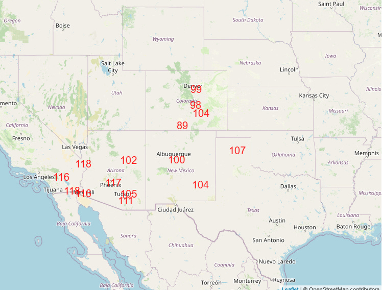
Turning now to the weather, today will see our most recent heat wave peak. Yesterday saw several record highs set in Arizona, with Flagstaff, Tucson, Phoenix and Prescott all setting new records. The heat will intensify and expand today, with record highs possible from southern California through Colorado. A few August monthly records could be set.
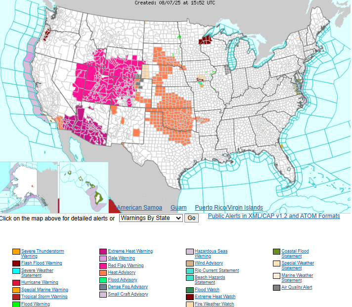
Extreme heat warnings are in effect for much of Arizona and the deserts of southern California for today, with heat advisories for much of the central Plains where the combination of above normal temperatures and humidity will push heat risk into the major category. Red flag warnings also remain in place for much of the Intermountain West and Great Basin for the next couple of days as an upper level disturbance and cold front will cause increasing winds and fire danger given hot and dry conditions.
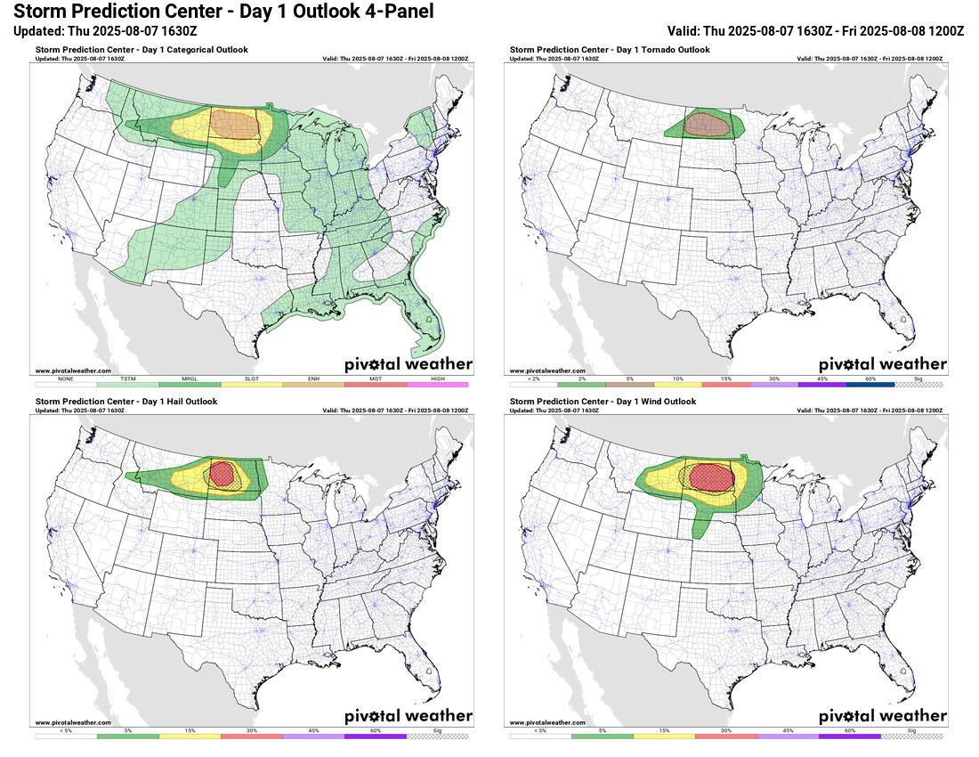
That upper level weather disturbance will also be responsible for a significant severe weather risk later today in the northern Plains and focused over much of North Dakota. Scattered supercell thunderstorms are expected to develop over the region with very large hail, wind gusts greater than 70 mph, and tornadoes possible with the most intense storms.
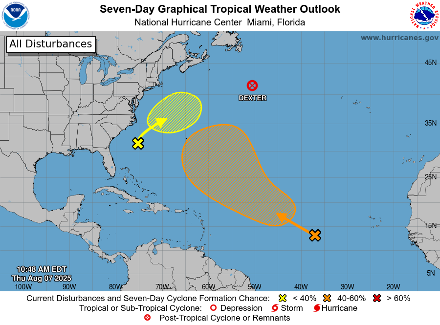
Updating the tropics, Dexter has now transitioned to an (intense) post-tropical low pressure system in the north Atlantic. The system in the central Atlantic has now been given a formal invest designation — 96L — which means that specific tropical cyclone models will now be run for the system. The National Hurricane Center continues to show a 60% probability of development for the system.
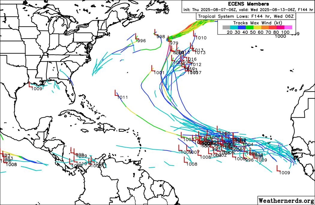
I will say that overall the models appear to me to have become less bullish on this system in the last 24 hours, with only a couple of the 50 European ensemble members showing it becoming more than than a tropical depression. The Google DeepMind AI system does not really have any of its ensemble members showing development at this point. Regardless, it seems almost certain that any system that comes from this will recurve over the Atlantic and remain east even of Bermuda.
With regard to our potential areas of interest closer to the US, NHC has lowered the probability of development of the system off the Carolinas to just 30 percent, and it appears as though any development that would happen would be more subtropical in nature as it starts to move out into northern Atlantic.
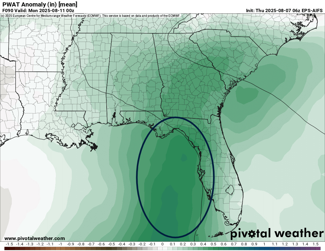
While still not designated as an area of concern by NHC, several members of the European ensemble and the Google AI system continue to show a weak system developing in the eastern Gulf of Mexico this week or early next week from the weak area of low pressure is now near Andros Island in the Bahamas. If nothing else, this system should bring a surge of increased moisture and rainfall into Florida this weekend and Gulf Coast region early next week as shown by the European ensemble precipitable water anomaly above (forecast for Sunday evening).
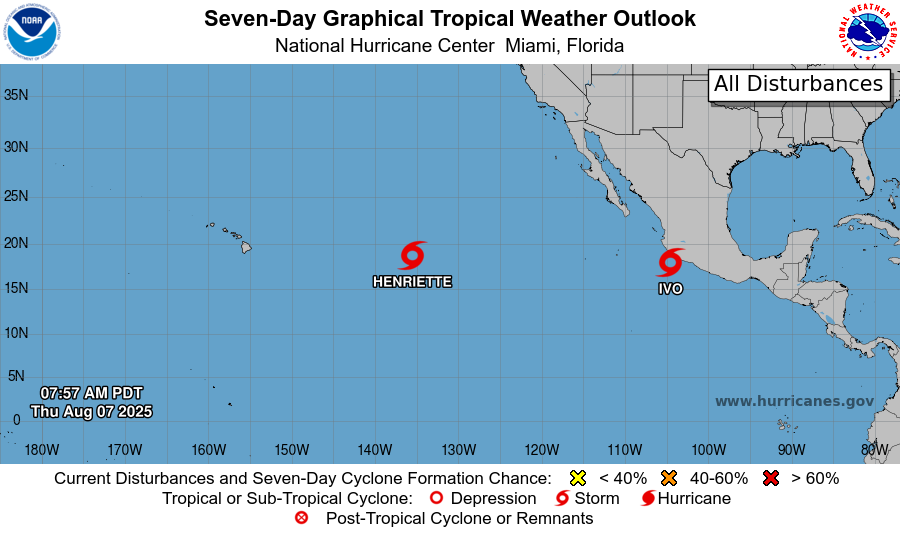
Meanwhile, in the Pacific, Tropical Storm Ivo has formed near the southwest coast of Mexico, where it is producing some heavy rainfall. Ivo is expected to gradually intensify but will be moving west-northwest away from the coast. Henriette continues to churn west-northwest in the east-central Pacific and is forecast to turn more northwest and pass well north of Hawaii. As we discussed yesterday, Henriette looks as if it will actually become better organized once it gets to the longitude of Hawaii, and is now forecast by NHC to become a hurricane well north of the state early next week.

Leave a comment